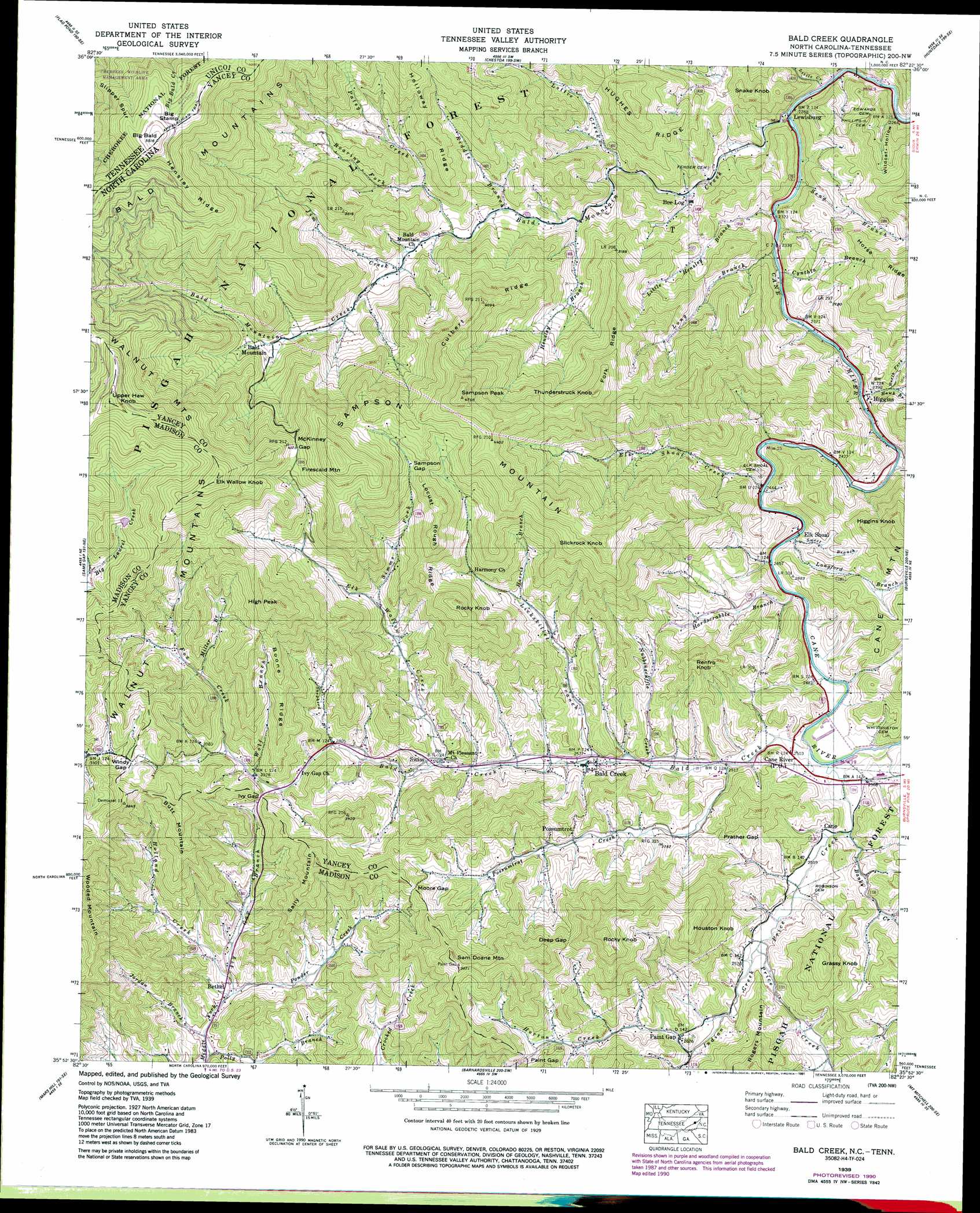
Bald Creek Topo Map North Carolina
To zoom in, hover over the map of Bald Creek
USGS Topo Quad 35082h4 - 1:24,000 scale
| Topo Map Name: | Bald Creek |
| USGS Topo Quad ID: | 35082h4 |
| Print Size: | ca. 21 1/4" wide x 27" high |
| Southeast Coordinates: | 35.875° N latitude / 82.375° W longitude |
| Map Center Coordinates: | 35.9375° N latitude / 82.4375° W longitude |
| U.S. States: | NC, TN |
| Filename: | o35082h4.jpg |
| Download Map JPG Image: | Bald Creek topo map 1:24,000 scale |
| Map Type: | Topographic |
| Topo Series: | 7.5´ |
| Map Scale: | 1:24,000 |
| Source of Map Images: | United States Geological Survey (USGS) |
| Alternate Map Versions: |
Bald Creek NC 1935 Download PDF Buy paper map Bald Creek NC 1939 Download PDF Buy paper map Bald Creek NC 1939 Download PDF Buy paper map Bald Creek NC 1939, updated 1957 Download PDF Buy paper map Bald Creek NC 1939, updated 1966 Download PDF Buy paper map Bald Creek NC 1939, updated 1973 Download PDF Buy paper map Bald Creek NC 1939, updated 1979 Download PDF Buy paper map Bald Creek NC 1939, updated 1991 Download PDF Buy paper map Bald Creek NC 2011 Download PDF Buy paper map Bald Creek NC 2013 Download PDF Buy paper map Bald Creek NC 2016 Download PDF Buy paper map |
| FStopo: | US Forest Service topo Bald Creek is available: Download FStopo PDF Download FStopo TIF |
1:24,000 Topo Quads surrounding Bald Creek
Chuckey |
Telford |
Erwin |
Unicoi |
Iron Mountain Gap |
Greystone |
Flag Pond |
Chestoa |
Huntdale |
Bakersville |
White Rock |
Sams Gap |
Bald Creek |
Burnsville |
Micaville |
Marshall |
Mars Hill |
Barnardsville |
Mount Mitchell |
Celo |
Leicester |
Weaverville |
Craggy Pinnacle |
Montreat |
Old Fort |
> Back to 35082e1 at 1:100,000 scale
> Back to 35082a1 at 1:250,000 scale
> Back to U.S. Topo Maps home
Bald Creek topo map: Gazetteer
Bald Creek: Dams
Mars Hill Reservoir Dam elevation 1216m 3989′Bald Creek: Gaps
Deep Gap elevation 1003m 3290′Ivy Gap elevation 892m 2926′
McKinney Gap elevation 1245m 4084′
Moore Gap elevation 928m 3044′
Paint Gap elevation 893m 2929′
Prather Gap elevation 822m 2696′
Sampson Gap elevation 1205m 3953′
Windy Gap elevation 1054m 3458′
Bald Creek: Populated Places
Bald Creek elevation 798m 2618′Bald Mountain elevation 981m 3218′
Bee Log elevation 738m 2421′
Bethel elevation 722m 2368′
Cane elevation 767m 2516′
Cane River elevation 761m 2496′
Elk Shoal elevation 745m 2444′
Hensley (historical) elevation 871m 2857′
Higgins elevation 735m 2411′
Lewisburg elevation 711m 2332′
Paint Gap elevation 816m 2677′
Possumtrot elevation 830m 2723′
Swiss elevation 842m 2762′
Bald Creek: Reservoirs
Mars Hill Reservoir elevation 1216m 3989′Bald Creek: Ridges
Boone Ridge elevation 1048m 3438′Culbert Ridge elevation 1238m 4061′
Fork Ridge elevation 1200m 3937′
Hensley Ridge elevation 1557m 5108′
Holloway Ridge elevation 1100m 3608′
Locust Rough Ridge elevation 1215m 3986′
Bald Creek: Streams
Bald Creek elevation 755m 2477′Bald Mountain Creek elevation 691m 2267′
Banks Creek elevation 761m 2496′
Cynthia Branch elevation 720m 2362′
Elk Shoal Creek elevation 748m 2454′
Elk Wallow Creek elevation 813m 2667′
Feds Branch elevation 686m 2250′
Fox Creek elevation 915m 3001′
Hardscrabble Branch elevation 746m 2447′
Harris Branch elevation 886m 2906′
Hawk Branch elevation 726m 2381′
Hensley Branch elevation 794m 2604′
Higgins Creek elevation 727m 2385′
Holland Creek elevation 732m 2401′
Horton Creek elevation 796m 2611′
Indian Creek elevation 777m 2549′
Ivy Gap Branch elevation 729m 2391′
Jim Creek elevation 883m 2896′
Jordan Branch elevation 714m 2342′
Langford Branch elevation 743m 2437′
Lickskillet Branch elevation 784m 2572′
Little Creek elevation 688m 2257′
Little Hensley Branch elevation 720m 2362′
Long Branch elevation 708m 2322′
Lottie Creek elevation 762m 2500′
Medrith Branch elevation 686m 2250′
Middle Fork Hawk Branch elevation 776m 2545′
Miller Branch elevation 974m 3195′
North Fork Hawk Branch elevation 757m 2483′
Nubbinscuffle Creek elevation 774m 2539′
Patsy Creek elevation 855m 2805′
Polly Branch elevation 709m 2326′
Ponder Creek elevation 724m 2375′
Possumtrot Creek elevation 766m 2513′
Price Creek elevation 757m 2483′
Riddle Branch elevation 826m 2709′
Roaring Fork elevation 913m 2995′
Seng Branch elevation 704m 2309′
Shepherd Branch elevation 855m 2805′
Simms Fork elevation 921m 3021′
South Fork Hawk Branch elevation 776m 2545′
Sweet Branch elevation 748m 2454′
Wolf Branch elevation 891m 2923′
Bald Creek: Summits
Big Bald elevation 1674m 5492′Big Bald elevation 1674m 5492′
Big Stamp elevation 1639m 5377′
Butt Mountain elevation 1128m 3700′
Elk Wallow Knob elevation 1444m 4737′
Firescald Mountain elevation 1437m 4714′
Grassy Knob elevation 1029m 3375′
Higgins Knob elevation 1037m 3402′
High Peak elevation 1333m 4373′
Houston Knob elevation 1075m 3526′
Renfro Knob elevation 991m 3251′
Rocky Knob elevation 1155m 3789′
Rocky Knob elevation 1202m 3943′
Sally Mountain elevation 1118m 3667′
Sam Doane Mountain elevation 1103m 3618′
Sampson Mountain elevation 1459m 4786′
Sampson Peak elevation 1440m 4724′
Slickrock Knob elevation 1303m 4274′
Snake Knob elevation 886m 2906′
Thunderstruck Knob elevation 1287m 4222′
Upper Haw Knob elevation 1487m 4878′
Bald Creek: Valleys
Wildcat Hollow elevation 684m 2244′Bald Creek digital topo map on disk
Buy this Bald Creek topo map showing relief, roads, GPS coordinates and other geographical features, as a high-resolution digital map file on DVD:
South Carolina, Western North Carolina & Northeastern Georgia
Buy digital topo maps: South Carolina, Western North Carolina & Northeastern Georgia