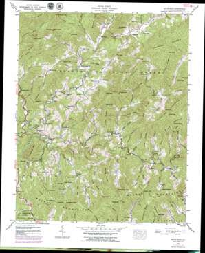
White Rock Topo Map North Carolina
To zoom in, hover over the map of White Rock
USGS Topo Quad 35082h6 - 1:24,000 scale
| Topo Map Name: | White Rock |
| USGS Topo Quad ID: | 35082h6 |
| Print Size: | ca. 21 1/4" wide x 27" high |
| Southeast Coordinates: | 35.875° N latitude / 82.625° W longitude |
| Map Center Coordinates: | 35.9375° N latitude / 82.6875° W longitude |
| U.S. State: | NC |
| Filename: | o35082h6.jpg |
| Download Map JPG Image: | White Rock topo map 1:24,000 scale |
| Map Type: | Topographic |
| Topo Series: | 7.5´ |
| Map Scale: | 1:24,000 |
| Source of Map Images: | United States Geological Survey (USGS) |
| Alternate Map Versions: |
White Rock NC 1936 Download PDF Buy paper map White Rock NC 1939, updated 1957 Download PDF Buy paper map White Rock NC 1939, updated 1972 Download PDF Buy paper map White Rock NC 1939, updated 1976 Download PDF Buy paper map White Rock NC 1939, updated 1979 Download PDF Buy paper map White Rock NC 1939, updated 1988 Download PDF Buy paper map White Rock NC 1940 Download PDF Buy paper map White Rock NC 1940 Download PDF Buy paper map White Rock NC 2011 Download PDF Buy paper map White Rock NC 2013 Download PDF Buy paper map White Rock NC 2016 Download PDF Buy paper map |
| FStopo: | US Forest Service topo White Rock is available: Download FStopo PDF Download FStopo TIF |
1:24,000 Topo Quads surrounding White Rock
> Back to 35082e1 at 1:100,000 scale
> Back to 35082a1 at 1:250,000 scale
> Back to U.S. Topo Maps home
White Rock topo map: Gazetteer
White Rock: Gaps
Andy Gap elevation 908m 2979′Billy Gap elevation 742m 2434′
Cargle Gap elevation 886m 2906′
Graveyard Gap elevation 600m 1968′
Hopewell Gap elevation 714m 2342′
Locust Gap elevation 953m 3126′
Lovada Gap elevation 1115m 3658′
Low Gap elevation 739m 2424′
Mile Gap elevation 745m 2444′
Potato Gap elevation 1004m 3293′
Potato Gap elevation 1016m 3333′
Pounding Mill Gap elevation 993m 3257′
Walnut Gap elevation 931m 3054′
White Rock: Populated Places
Allegheny elevation 641m 2103′Andy Cove elevation 678m 2224′
Belva elevation 517m 1696′
Big Laurel elevation 630m 2066′
Chapel Hill elevation 658m 2158′
Cutshalltown elevation 659m 2162′
Guntertown elevation 609m 1998′
Jarrett Cove elevation 764m 2506′
Lumptown elevation 888m 2913′
Revere elevation 665m 2181′
Rice Mill elevation 603m 1978′
Spillcorn elevation 856m 2808′
White Rock elevation 573m 1879′
White Rock: Ridges
Allen Ridge elevation 771m 2529′Alum Ridge elevation 822m 2696′
Appletree Ridge elevation 1043m 3421′
Big Ridge elevation 815m 2673′
Deading Ridge elevation 847m 2778′
Grassy Ridge elevation 948m 3110′
Highrock Ridge elevation 786m 2578′
Middle Ridge elevation 1179m 3868′
Odell Ridge elevation 814m 2670′
Pilot Ridge elevation 746m 2447′
Rod Ridge elevation 1037m 3402′
Shinbone Ridge elevation 1008m 3307′
Turkeypen Ridge elevation 764m 2506′
White Rock: Streams
Amos Creek elevation 869m 2851′Baker Creek elevation 869m 2851′
Barnes Branch elevation 560m 1837′
Bearpen Branch elevation 597m 1958′
Billy King Branch elevation 532m 1745′
Buckner Branch elevation 611m 2004′
Calvin Creek elevation 872m 2860′
Crane Branch elevation 564m 1850′
Cutshall Branch elevation 597m 1958′
Duckmill Creek elevation 598m 1961′
East Prong Hickey Fork elevation 660m 2165′
Gunter Branch elevation 545m 1788′
Hensley Branch elevation 669m 2194′
Hickey Fork elevation 624m 2047′
Hickorylog Branch elevation 649m 2129′
Highshoal Branch elevation 526m 1725′
Johnson Branch elevation 584m 1916′
Lewis Branch elevation 638m 2093′
Lisenbee Branch elevation 808m 2650′
Little Laurel Creek elevation 511m 1676′
Palmer Camp Branch elevation 608m 1994′
Pine Branch elevation 645m 2116′
Rock Branch elevation 628m 2060′
Roddy Branch elevation 544m 1784′
Shade Branch elevation 575m 1886′
Shelton Branch elevation 550m 1804′
Sodom Branch elevation 543m 1781′
Spillcorn Creek elevation 579m 1899′
Tarlton Branch elevation 592m 1942′
Wallin Branch elevation 618m 2027′
Watermelon Branch elevation 646m 2119′
West Prong Hickey Fork elevation 661m 2168′
Wild Branch elevation 633m 2076′
Wolf Branch elevation 688m 2257′
White Rock: Summits
Alum Knob elevation 1016m 3333′Angelico Knob elevation 1042m 3418′
Big Knob elevation 1282m 4206′
Buck Knob elevation 796m 2611′
Devils Den Mountain elevation 1098m 3602′
Franklin Mountain elevation 831m 2726′
Gosnell Knob elevation 1004m 3293′
Hack Knob elevation 1249m 4097′
Hicks Mountain elevation 1078m 3536′
High Knob elevation 1099m 3605′
Highrock elevation 774m 2539′
Huckleberry Knob elevation 881m 2890′
Licklog Knob elevation 989m 3244′
Locust Knob elevation 1071m 3513′
Lone Knob elevation 946m 3103′
Lonesome Mountain elevation 849m 2785′
Mill Knob elevation 800m 2624′
Mitchell Knob elevation 1075m 3526′
Mollie Mountain elevation 919m 3015′
No Business Knob elevation 741m 2431′
Redoak Mountain elevation 733m 2404′
Richland Mountain elevation 1189m 3900′
Rock Knob elevation 1021m 3349′
Roddy Mountain elevation 847m 2778′
Sapling Mountain elevation 848m 2782′
Sheepstamp Knob elevation 1082m 3549′
Sodom Mountain elevation 1047m 3435′
Turkeypen Knob elevation 1052m 3451′
Wolf Mountain elevation 870m 2854′
White Rock: Trails
Pounding Mill Trail elevation 974m 3195′White Rock: Valleys
Brigman Hollow elevation 543m 1781′Burton Cove elevation 669m 2194′
Capps Hollow elevation 690m 2263′
Hog Cove elevation 688m 2257′
Rice Cove elevation 587m 1925′
Tett Cove elevation 563m 1847′
White Rock digital topo map on disk
Buy this White Rock topo map showing relief, roads, GPS coordinates and other geographical features, as a high-resolution digital map file on DVD:
South Carolina, Western North Carolina & Northeastern Georgia
Buy digital topo maps: South Carolina, Western North Carolina & Northeastern Georgia


