Paint Rock Topo Map Tennessee
To zoom in, hover over the map of Paint Rock
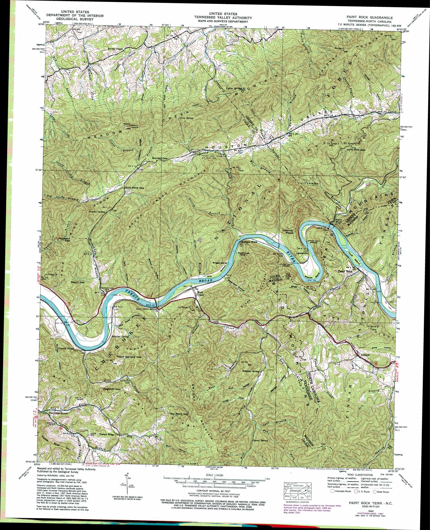
USGS Topo Quad 35082h8 - 1:24,000 scale
| Topo Map Name: | Paint Rock |
| USGS Topo Quad ID: | 35082h8 |
| Print Size: | ca. 21 1/4" wide x 27" high |
| Southeast Coordinates: | 35.875° N latitude / 82.875° W longitude |
| Map Center Coordinates: | 35.9375° N latitude / 82.9375° W longitude |
| U.S. States: | TN, NC |
| Filename: | o35082h8.jpg |
| Download Map JPG Image: | Paint Rock topo map 1:24,000 scale |
| Map Type: | Topographic |
| Topo Series: | 7.5´ |
| Map Scale: | 1:24,000 |
| Source of Map Images: | United States Geological Survey (USGS) |
| Alternate Map Versions: |
Paint Rock NC 1935 Download PDF Buy paper map Paint Rock NC 1940 Download PDF Buy paper map Paint Rock NC 1940, updated 1954 Download PDF Buy paper map Paint Rock NC 1940, updated 1974 Download PDF Buy paper map Paint Rock NC 1940, updated 1992 Download PDF Buy paper map Paint Rock NC 2003, updated 2004 Download PDF Buy paper map Paint Rock NC 2011 Download PDF Buy paper map Paint Rock NC 2013 Download PDF Buy paper map Paint Rock NC 2016 Download PDF Buy paper map |
| FStopo: | US Forest Service topo Paint Rock is available: Download FStopo PDF Download FStopo TIF |
1:24,000 Topo Quads surrounding Paint Rock
Springvale |
Mohawk |
Mosheim |
Greeneville |
Chuckey |
Rankin |
Parrotsville |
Cedar Creek |
Davy Crockett Lake |
Greystone |
Newport |
Neddy Mountain |
Paint Rock |
Hot Springs |
White Rock |
Hartford |
Waterville |
Lemon Gap |
Spring Creek |
Marshall |
Luftee Knob |
Cove Creek Gap |
Fines Creek |
Sandymush |
Leicester |
> Back to 35082e1 at 1:100,000 scale
> Back to 35082a1 at 1:250,000 scale
> Back to U.S. Topo Maps home
Paint Rock topo map: Gazetteer
Paint Rock: Bends
Mile Bottom elevation 361m 1184′Mile Bottom elevation 361m 1184′
Weaver Bend elevation 380m 1246′
Weaver Bend elevation 374m 1227′
Paint Rock: Bridges
Grooms Bridge elevation 349m 1145′Lower Twin Bridge elevation 367m 1204′
Lower Twin Bridge elevation 367m 1204′
Upper Twin Bridge elevation 373m 1223′
Upper Twin Bridge elevation 373m 1223′
Wolf Creek Bridge elevation 354m 1161′
Paint Rock: Cliffs
Chimney Rocks elevation 451m 1479′Paint Rock: Dams
Allen Branch Fish Pond Dam elevation 494m 1620′Paint Rock: Gaps
Beech Gap elevation 454m 1489′Beech Gap elevation 474m 1555′
Burnett Gap elevation 627m 2057′
Burnett Gap elevation 618m 2027′
Dogwood Gap elevation 493m 1617′
Dogwood Gap elevation 498m 1633′
Dry Pond Gap elevation 602m 1975′
Dry Pond Gap elevation 607m 1991′
Gold Mine Gap elevation 541m 1774′
Gold Mine Gap elevation 543m 1781′
Lone Pine Gap elevation 679m 2227′
Lone Pine Gap elevation 675m 2214′
Mocassin Gap elevation 538m 1765′
Mocassin Gap elevation 513m 1683′
Peach Orchard Gap elevation 512m 1679′
Paint Rock: Islands
Briggs Island elevation 361m 1184′Briggs Island elevation 361m 1184′
Huff Island elevation 380m 1246′
Paint Rock: Mines
Brushy Mountain Prospect elevation 726m 2381′Bry Fork Prospect elevation 722m 2368′
Cross Mountain Prospect elevation 587m 1925′
Krebs Mine elevation 662m 2171′
Moccasin Gap Mine elevation 539m 1768′
Mooneyham Mine elevation 492m 1614′
Williams Mine elevation 795m 2608′
Wood Mine elevation 664m 2178′
Paint Rock: Parks
French Broad Recreation Site elevation 355m 1164′Houston Valley Recreation Area elevation 536m 1758′
Paint Rock: Pillars
Buffalo Rock elevation 371m 1217′Paint Rock elevation 399m 1309′
Paint Rock: Populated Places
Antioch elevation 483m 1584′French Broad elevation 353m 1158′
Harmony Grove elevation 392m 1286′
Houston Valley elevation 537m 1761′
Jonestown (historical) elevation 495m 1624′
Lanceville elevation 399m 1309′
Paint Rock elevation 386m 1266′
Unaka Station (historical) elevation 382m 1253′
Wolf Creek elevation 369m 1210′
Paint Rock: Reservoirs
Allen Branch Fish Pond elevation 494m 1620′Paint Rock: Ridges
Big Hill elevation 441m 1446′Chuckey Mountain elevation 670m 2198′
Gold Mine Ridge elevation 602m 1975′
Gold Mine Ridge elevation 575m 1886′
Mine Ridge elevation 554m 1817′
Orebank Ridge elevation 700m 2296′
Paint Mountain elevation 626m 2053′
Timber Ridge elevation 615m 2017′
Timber Ridge elevation 620m 2034′
Paint Rock: Springs
Gum Spring elevation 714m 2342′Gum Spring elevation 721m 2365′
Powder Spring elevation 483m 1584′
Powder Spring elevation 465m 1525′
Spout Spring elevation 543m 1781′
Spout Spring elevation 530m 1738′
Sulpher Spring elevation 471m 1545′
Sulphur Spring elevation 391m 1282′
Sulphur Spring elevation 479m 1571′
Sulphur Spring elevation 391m 1282′
Yellow Spring elevation 736m 2414′
Yellow Springs elevation 736m 2414′
Paint Rock: Streams
Allen Branch elevation 360m 1181′Austin Branch elevation 395m 1295′
Austin Branch elevation 413m 1354′
Bailey Branch elevation 405m 1328′
Bailey Branch elevation 407m 1335′
Bear Branch elevation 429m 1407′
Bear Branch elevation 428m 1404′
Bee Branch elevation 379m 1243′
Beech Branch elevation 534m 1751′
Beech Branch elevation 533m 1748′
Big Cliffy Branch elevation 465m 1525′
Big Clifty Branch elevation 475m 1558′
Brush Creek elevation 363m 1190′
Brush Creek elevation 363m 1190′
Burgen Branch elevation 555m 1820′
Capps Branch elevation 546m 1791′
Capps Branch elevation 543m 1781′
Clear Branch elevation 510m 1673′
Clover Branch elevation 381m 1250′
Coon Branch elevation 506m 1660′
Coon Branch elevation 537m 1761′
Coulter Branch elevation 542m 1778′
Coulter Branch elevation 541m 1774′
Cummins Branch elevation 393m 1289′
Cummins Branch elevation 394m 1292′
Davis Branch elevation 384m 1259′
Doe Branch elevation 486m 1594′
Doe Branch elevation 486m 1594′
Dry Branch elevation 452m 1482′
Dry Branch elevation 413m 1354′
East Fork Shut-In Creek elevation 555m 1820′
Fed Fork elevation 512m 1679′
Fed Fork elevation 511m 1676′
Granny Branch elevation 390m 1279′
Granny Branch elevation 397m 1302′
Grass Creek elevation 381m 1250′
Gum Spring Branch elevation 506m 1660′
Kill Dee Branch elevation 386m 1266′
Little Cliffy Branch elevation 479m 1571′
Little Clifty Branch elevation 475m 1558′
Mooneyham Branch elevation 350m 1148′
Mooneyham Branch elevation 605m 1984′
Paint Creek elevation 379m 1243′
Paint Creek elevation 382m 1253′
Rock Creek elevation 350m 1148′
Rock Creek elevation 350m 1148′
West Branch Brush Creek elevation 522m 1712′
West Branch Cove Creek elevation 521m 1709′
Wolf Creek elevation 357m 1171′
Paint Rock: Summits
Big Hill elevation 526m 1725′Brush Creek Mountain elevation 842m 2762′
Buffalo Rock elevation 513m 1683′
Chimney Rocks elevation 512m 1679′
Chuckey Mountain elevation 940m 3083′
Cross Mountain elevation 729m 2391′
Cross Mountain elevation 723m 2372′
Paint Mountain elevation 800m 2624′
Paint Rock elevation 540m 1771′
Punch Bowl Mountain elevation 593m 1945′
Punch Bowl Mountain elevation 569m 1866′
Sawyer Mountain elevation 655m 2148′
Sawyer Mountain elevation 650m 2132′
Paint Rock: Trails
Chimney Rocks Trail elevation 639m 2096′Gum Springs Trail elevation 608m 1994′
Meadow Creek Mountain Trail elevation 832m 2729′
Paint Mountain Trail elevation 742m 2434′
Tweed Trail elevation 573m 1879′
Tweed Trail elevation 576m 1889′
Paint Rock: Valleys
Barnett Hollow elevation 355m 1164′Beetree Hollow elevation 364m 1194′
Betree Hollow elevation 360m 1181′
Brady Hollow elevation 417m 1368′
Bryant Hollow elevation 376m 1233′
Bryant Hollow elevation 360m 1181′
Bull Hollow elevation 602m 1975′
Bull Hollow elevation 598m 1961′
Burnett Hollow elevation 352m 1154′
Carilse Hollow elevation 524m 1719′
Carlisle Hollow elevation 530m 1738′
Cindy Cove elevation 489m 1604′
Cindy Cove elevation 489m 1604′
George Hollow elevation 462m 1515′
George Hollow elevation 467m 1532′
Gunter Hollow elevation 465m 1525′
Gunter Hollow elevation 453m 1486′
Horseshoe Hollow elevation 426m 1397′
Houston Valley elevation 527m 1729′
Mill Rock Hollow elevation 462m 1515′
Mill Rock Hollow elevation 508m 1666′
Mud Hollow elevation 462m 1515′
Mud Hollow elevation 463m 1519′
Pole Road Hollow elevation 370m 1213′
Pole Road Hollow elevation 358m 1174′
Polecat Hollow elevation 385m 1263′
Teno Hollow elevation 362m 1187′
Watertank Hollow elevation 389m 1276′
Watertank Hollow elevation 378m 1240′
Paint Rock digital topo map on disk
Buy this Paint Rock topo map showing relief, roads, GPS coordinates and other geographical features, as a high-resolution digital map file on DVD:
South Carolina, Western North Carolina & Northeastern Georgia
Buy digital topo maps: South Carolina, Western North Carolina & Northeastern Georgia