Peachtree Topo Map North Carolina
To zoom in, hover over the map of Peachtree
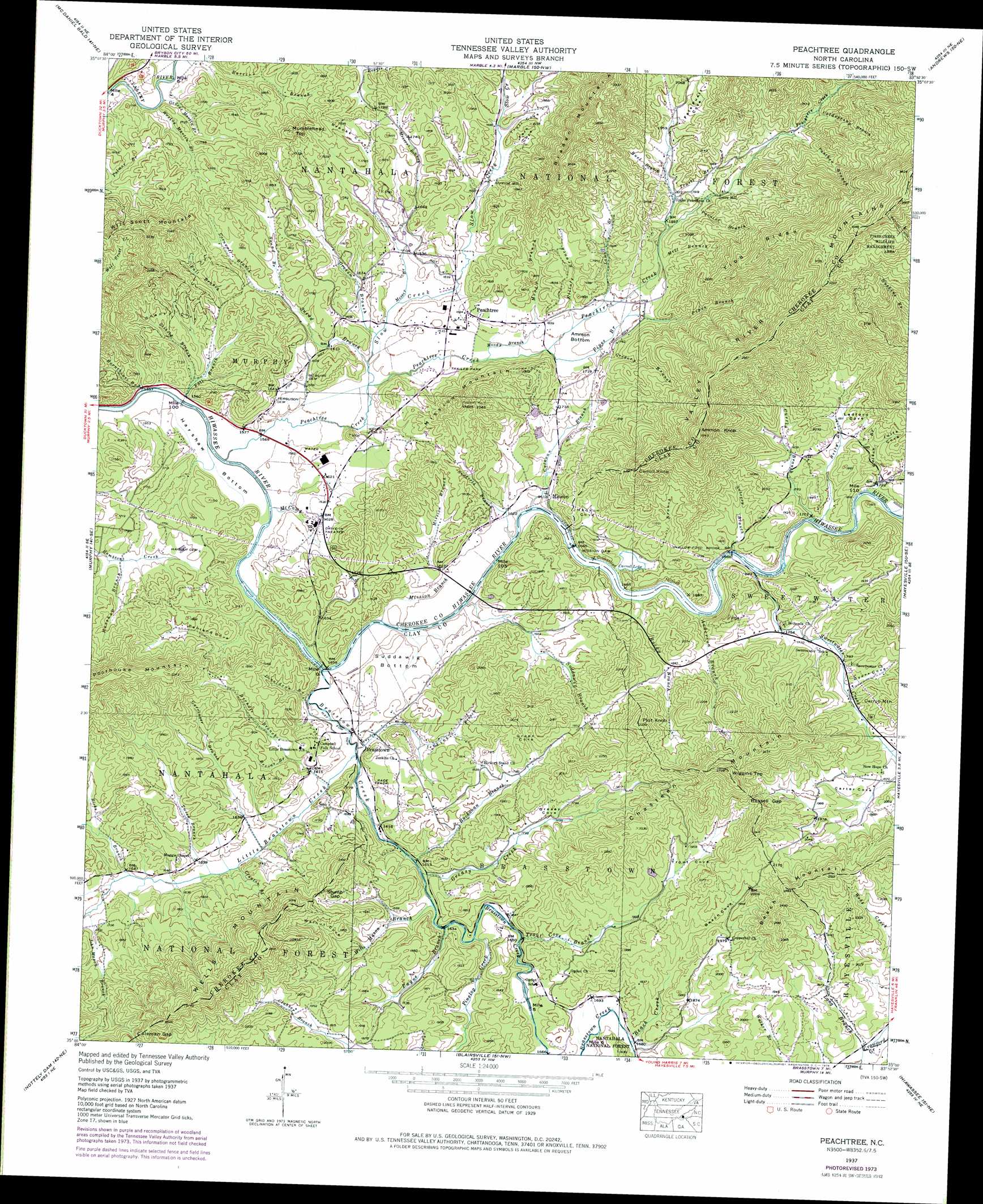
USGS Topo Quad 35083a8 - 1:24,000 scale
| Topo Map Name: | Peachtree |
| USGS Topo Quad ID: | 35083a8 |
| Print Size: | ca. 21 1/4" wide x 27" high |
| Southeast Coordinates: | 35° N latitude / 83.875° W longitude |
| Map Center Coordinates: | 35.0625° N latitude / 83.9375° W longitude |
| U.S. State: | NC |
| Filename: | o35083a8.jpg |
| Download Map JPG Image: | Peachtree topo map 1:24,000 scale |
| Map Type: | Topographic |
| Topo Series: | 7.5´ |
| Map Scale: | 1:24,000 |
| Source of Map Images: | United States Geological Survey (USGS) |
| Alternate Map Versions: |
Peachtree NC 1935 Download PDF Buy paper map Peachtree NC 1937, updated 1957 Download PDF Buy paper map Peachtree NC 1937, updated 1963 Download PDF Buy paper map Peachtree NC 1937, updated 1969 Download PDF Buy paper map Peachtree NC 1937, updated 1975 Download PDF Buy paper map Peachtree NC 1938 Download PDF Buy paper map Peachtree NC 2011 Download PDF Buy paper map Peachtree NC 2013 Download PDF Buy paper map Peachtree NC 2016 Download PDF Buy paper map |
| FStopo: | US Forest Service topo Peachtree is available: Download FStopo PDF Download FStopo TIF |
1:24,000 Topo Quads surrounding Peachtree
Bald River Falls |
Big Junction |
Santeetlah Creek |
Robbinsville |
Hewitt |
Unaka |
Mcdaniel Bald |
Marble |
Andrews |
Topton |
Persimmon Creek |
Murphy |
Peachtree |
Hayesville |
Shooting Creek |
Culberson |
Nottely Dam |
Blairsville |
Hiawassee |
Macedonia |
Wilscot |
Mulky Gap |
Coosa Bald |
Jacks Gap |
Tray Mountain |
> Back to 35083a1 at 1:100,000 scale
> Back to 35082a1 at 1:250,000 scale
> Back to U.S. Topo Maps home
Peachtree topo map: Gazetteer
Peachtree: Bends
Harshaw Bottom elevation 476m 1561′Suddawig Bottom elevation 498m 1633′
Peachtree: Bridges
Shallow Ford Bridge elevation 514m 1686′Peachtree: Dams
Carrol Lake Dam elevation 513m 1683′Mission Dam elevation 499m 1637′
Mission Dam elevation 560m 1837′
Peachtree: Flats
Ammon Bottom elevation 516m 1692′Peachtree: Gaps
Coleman Gap elevation 682m 2237′Russell Gap elevation 697m 2286′
Stump Gap elevation 595m 1952′
Peachtree: Lakes
Carroll Lake elevation 513m 1683′Peachtree: Populated Places
Arrwood Mill elevation 503m 1650′Brasstown elevation 489m 1604′
Jones Mill elevation 590m 1935′
Mission elevation 499m 1637′
Peachtree elevation 518m 1699′
Peachtree: Reservoirs
Mission Lake elevation 560m 1837′Peachtree: Ridges
Tibb Ridge elevation 788m 2585′Peachtree: Streams
Anderson Branch elevation 508m 1666′Auberry Branch elevation 511m 1676′
Beach Creek elevation 511m 1676′
Betty Branch elevation 514m 1686′
Bevins Branch elevation 501m 1643′
Brasstown Creek elevation 481m 1578′
Brendle Branch elevation 486m 1594′
Buchanan Branch elevation 490m 1607′
Burl Branch elevation 562m 1843′
Burnthouse Branch elevation 471m 1545′
Calhoun Branch elevation 490m 1607′
Carroll Branch elevation 513m 1683′
Carver Branch elevation 516m 1692′
Clayton Branch elevation 503m 1650′
Coldspring Branch elevation 672m 2204′
Cornwell Branch elevation 502m 1646′
Curtis Branch elevation 518m 1699′
Donaldson Branch elevation 483m 1584′
Elliott Branch elevation 516m 1692′
Fall Branch elevation 473m 1551′
Frankum Branch elevation 514m 1686′
Garringer Branch elevation 490m 1607′
George Martin Branch elevation 473m 1551′
Graham Branch elevation 487m 1597′
Greasy Creek elevation 490m 1607′
Gregory Branch elevation 519m 1702′
Gumlog Creek elevation 506m 1660′
Harshaw Branch elevation 494m 1620′
Jenkins Branch elevation 485m 1591′
John Mason Branch elevation 507m 1663′
Lamb Branch elevation 520m 1706′
Little Brasstown Creek elevation 484m 1587′
Long Branch elevation 536m 1758′
Mc Comb Branch elevation 477m 1564′
Messer Branch elevation 488m 1601′
Mill Branch elevation 529m 1735′
Mission Branch elevation 486m 1594′
Moody Branch elevation 500m 1640′
Painter Branch elevation 575m 1886′
Panther Branch elevation 645m 2116′
Payne Branch elevation 492m 1614′
Peachtree Creek elevation 474m 1555′
Peachtree Creek elevation 744m 2440′
Pinelog Creek elevation 499m 1637′
Pinhook Branch elevation 501m 1643′
Pipes Branch elevation 509m 1669′
Ricks Branch elevation 504m 1653′
Rocky Branch elevation 507m 1663′
Seibold Branch elevation 487m 1597′
Slow Creek elevation 484m 1587′
Snead Branch elevation 485m 1591′
Stamey Branch elevation 509m 1669′
Suddawig Branch elevation 489m 1604′
Sudderth Branch elevation 488m 1601′
Sweetwater Creek elevation 512m 1679′
Trout Cove Branch elevation 500m 1640′
Truett Branch elevation 572m 1876′
Tweed Branch elevation 492m 1614′
Watson Branch elevation 520m 1706′
Wesley Martin Branch elevation 473m 1551′
Will Mason Branch elevation 493m 1617′
Peachtree: Summits
Ammon Knob elevation 879m 2883′Beach Mountain elevation 725m 2378′
Braden Mountain elevation 866m 2841′
Carroll Knob elevation 774m 2539′
Chasteen Mountain elevation 816m 2677′
Mission Mountain elevation 638m 2093′
Mumblehead Top elevation 642m 2106′
Plot Knob elevation 725m 2378′
Wells Mountain elevation 790m 2591′
Wiggins Top elevation 784m 2572′
Will Scott Mountain elevation 660m 2165′
Peachtree: Valleys
Beach Cove elevation 514m 1686′Brooks Cove elevation 494m 1620′
Dyer Cove elevation 550m 1804′
Fain Cove elevation 510m 1673′
Fate Puett Cove elevation 569m 1866′
Greasy Cove elevation 499m 1637′
Green Cove elevation 549m 1801′
Henson Cove elevation 499m 1637′
Julie Cove elevation 548m 1797′
Ledford Cove elevation 541m 1774′
Penland Cove elevation 479m 1571′
Shanty Cove elevation 485m 1591′
Trout Cove elevation 569m 1866′
Trull Cove elevation 512m 1679′
Walnut Cove elevation 524m 1719′
Peachtree digital topo map on disk
Buy this Peachtree topo map showing relief, roads, GPS coordinates and other geographical features, as a high-resolution digital map file on DVD:
South Carolina, Western North Carolina & Northeastern Georgia
Buy digital topo maps: South Carolina, Western North Carolina & Northeastern Georgia