Topton Topo Map North Carolina
To zoom in, hover over the map of Topton
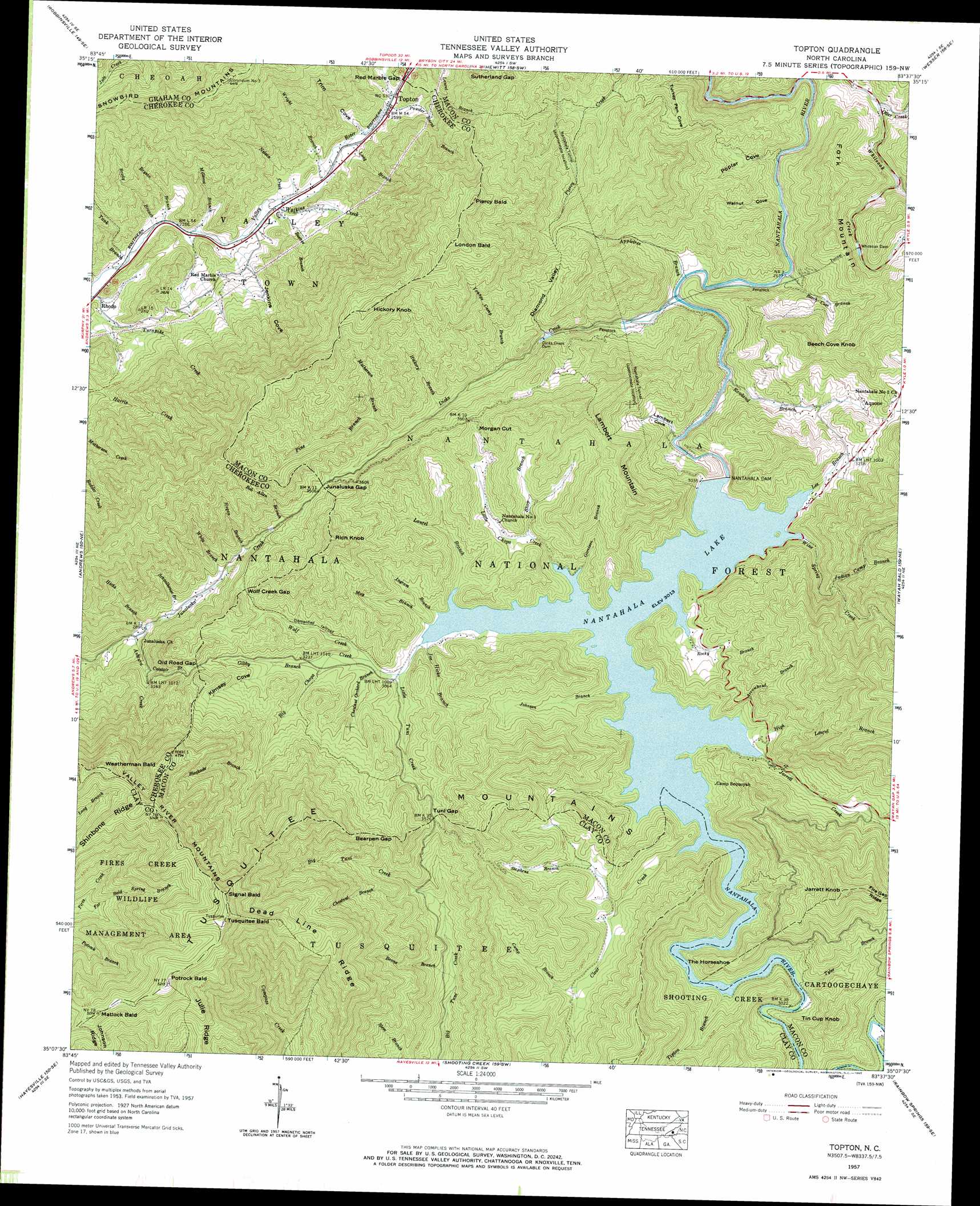
USGS Topo Quad 35083b6 - 1:24,000 scale
| Topo Map Name: | Topton |
| USGS Topo Quad ID: | 35083b6 |
| Print Size: | ca. 21 1/4" wide x 27" high |
| Southeast Coordinates: | 35.125° N latitude / 83.625° W longitude |
| Map Center Coordinates: | 35.1875° N latitude / 83.6875° W longitude |
| U.S. State: | NC |
| Filename: | o35083b6.jpg |
| Download Map JPG Image: | Topton topo map 1:24,000 scale |
| Map Type: | Topographic |
| Topo Series: | 7.5´ |
| Map Scale: | 1:24,000 |
| Source of Map Images: | United States Geological Survey (USGS) |
| Alternate Map Versions: |
Topton NC 1935 Download PDF Buy paper map Topton NC 1957, updated 1959 Download PDF Buy paper map Topton NC 1957, updated 1965 Download PDF Buy paper map Topton NC 1957, updated 1984 Download PDF Buy paper map Topton NC 2011 Download PDF Buy paper map Topton NC 2013 Download PDF Buy paper map Topton NC 2016 Download PDF Buy paper map |
| FStopo: | US Forest Service topo Topton is available: Download FStopo PDF Download FStopo TIF |
1:24,000 Topo Quads surrounding Topton
Tapoco |
Fontana Dam |
Tuskeegee |
Noland Creek |
Bryson City |
Santeetlah Creek |
Robbinsville |
Hewitt |
Wesser |
Alarka |
Marble |
Andrews |
Topton |
Wayah Bald |
Franklin |
Peachtree |
Hayesville |
Shooting Creek |
Rainbow Springs |
Prentiss |
Blairsville |
Hiawassee |
Macedonia |
Hightower Bald |
Dillard |
> Back to 35083a1 at 1:100,000 scale
> Back to 35082a1 at 1:250,000 scale
> Back to U.S. Topo Maps home
Topton topo map: Gazetteer
Topton: Bends
The Horseshoe elevation 1001m 3284′Topton: Canals
Penstock elevation 864m 2834′Topton: Dams
Dicks Creek Dam elevation 921m 3021′Nantahala Dam elevation 924m 3031′
Whiteoak Dam elevation 925m 3034′
Topton: Gaps
Bearpen Gap elevation 1122m 3681′Junaluska Gap elevation 1077m 3533′
Morgan Cut elevation 1060m 3477′
Old Road Gap elevation 1080m 3543′
Red Marble Gap elevation 821m 2693′
Sutherland Gap elevation 1067m 3500′
Tuni Gap elevation 1083m 3553′
Wolf Creek Gap elevation 1046m 3431′
Topton: Populated Places
Aquone elevation 1014m 3326′Topton elevation 809m 2654′
Topton: Reservoirs
Nantahala Lake elevation 925m 3034′Topton: Streams
Appletree Branch elevation 827m 2713′Arrowhead Branch elevation 917m 3008′
Ashturn Creek elevation 866m 2841′
Beech Cove Branch elevation 819m 2687′
Beetree Branch elevation 725m 2378′
Blockade Branch elevation 1103m 3618′
Bob Allen Branch elevation 1033m 3389′
Boone Branch elevation 864m 2834′
Brady Branch elevation 675m 2214′
Bryson Branch elevation 678m 2224′
Camp Branch elevation 1003m 3290′
Catstair Branch elevation 932m 3057′
Chestnut Branch elevation 958m 3143′
Chestnut Orchard Branch elevation 939m 3080′
Choga Creek elevation 917m 3008′
Clear Creek elevation 917m 3008′
Dicks Creek elevation 829m 2719′
Far Bald Spring Branch elevation 1106m 3628′
Garrison Branch elevation 919m 3015′
Gibby Branch elevation 964m 3162′
Hickory Branch elevation 992m 3254′
Hicks Branch elevation 861m 2824′
High Laurel Branch elevation 932m 3057′
Hogan Branch elevation 995m 3264′
Hurricane Creek elevation 995m 3264′
Indian Camp Branch elevation 1025m 3362′
Ingram Branch elevation 919m 3015′
Jarrett Creek elevation 918m 3011′
Joe Hicks Branch elevation 917m 3008′
Johnson Branch elevation 937m 3074′
Laurel Branch elevation 917m 3008′
Lee Branch elevation 917m 3008′
Little Choga Creek elevation 917m 3008′
Little Tuni Creek elevation 933m 3061′
Long Branch elevation 871m 2857′
Long Branch elevation 765m 2509′
Matherson Branch elevation 1037m 3402′
May Branch elevation 917m 3008′
Mill Branch elevation 653m 2142′
Millseat Branch elevation 688m 2257′
Nelson Creek elevation 733m 2404′
Otter Creek elevation 809m 2654′
Pine Branch elevation 1017m 3336′
Powder Burnt Branch elevation 810m 2657′
Rocky Branch elevation 917m 3008′
Rowland Branch elevation 839m 2752′
Schoolhouse Branch elevation 909m 2982′
Shop Branch elevation 957m 3139′
Silvermine Branch elevation 719m 2358′
Stephens Branch elevation 985m 3231′
Tank Branch elevation 663m 2175′
Tipton Branch elevation 917m 3008′
Tyler Branch elevation 920m 3018′
Watkins Creek elevation 714m 2342′
White Branch elevation 953m 3126′
Wine Spring Creek elevation 917m 3008′
Wolf Creek elevation 946m 3103′
Wright Branch elevation 755m 2477′
Youngs Camp Branch elevation 959m 3146′
Topton: Summits
Beech Cove Knob elevation 1124m 3687′Clay Knob elevation 1486m 4875′
Fork Mountain elevation 1073m 3520′
Hickory Knob elevation 1367m 4484′
Jarrett Knob elevation 1323m 4340′
Lambert Mountain elevation 1234m 4048′
London Bald elevation 1401m 4596′
Matlock Bald elevation 1518m 4980′
Piercy Bald elevation 1339m 4393′
Potrock Bald elevation 1575m 5167′
Rich Knob elevation 1283m 4209′
Signal Bald elevation 1573m 5160′
Tin Cup Knob elevation 1130m 3707′
Tusquitee Bald elevation 1572m 5157′
Weatherman Bald elevation 1490m 4888′
Topton: Trails
CHoga Trail elevation 1123m 3684′Topton: Tunnels
Nantahala Tunnel elevation 935m 3067′Topton: Valleys
Diamond Valley elevation 924m 3031′Jenkins Cove elevation 713m 2339′
Kimsey Cove elevation 992m 3254′
Lambert Cove elevation 844m 2769′
Poplar Cove elevation 800m 2624′
Trim Cove elevation 782m 2565′
Turkey Pen Cove elevation 703m 2306′
Walnut Cove elevation 802m 2631′
Topton digital topo map on disk
Buy this Topton topo map showing relief, roads, GPS coordinates and other geographical features, as a high-resolution digital map file on DVD:
South Carolina, Western North Carolina & Northeastern Georgia
Buy digital topo maps: South Carolina, Western North Carolina & Northeastern Georgia