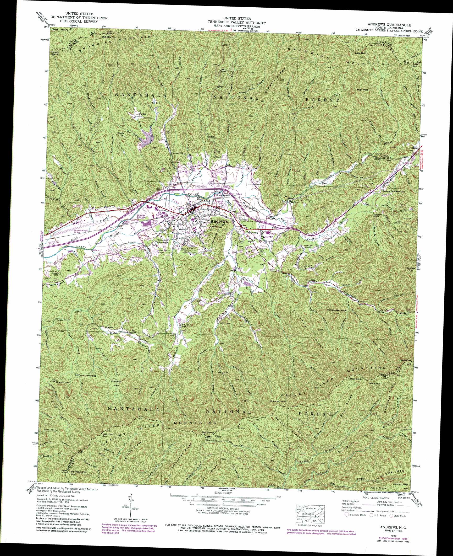
Andrews Topo Map North Carolina
To zoom in, hover over the map of Andrews
USGS Topo Quad 35083b7 - 1:24,000 scale
| Topo Map Name: | Andrews |
| USGS Topo Quad ID: | 35083b7 |
| Print Size: | ca. 21 1/4" wide x 27" high |
| Southeast Coordinates: | 35.125° N latitude / 83.75° W longitude |
| Map Center Coordinates: | 35.1875° N latitude / 83.8125° W longitude |
| U.S. State: | NC |
| Filename: | o35083b7.jpg |
| Download Map JPG Image: | Andrews topo map 1:24,000 scale |
| Map Type: | Topographic |
| Topo Series: | 7.5´ |
| Map Scale: | 1:24,000 |
| Source of Map Images: | United States Geological Survey (USGS) |
| Alternate Map Versions: |
Andrews NC 1935 Download PDF Buy paper map Andrews NC 1938 Download PDF Buy paper map Andrews NC 1938, updated 1957 Download PDF Buy paper map Andrews NC 1938, updated 1963 Download PDF Buy paper map Andrews NC 1938, updated 1969 Download PDF Buy paper map Andrews NC 1938, updated 1975 Download PDF Buy paper map Andrews NC 1938, updated 1991 Download PDF Buy paper map Andrews NC 1938, updated 1991 Download PDF Buy paper map Andrews NC 2011 Download PDF Buy paper map Andrews NC 2013 Download PDF Buy paper map Andrews NC 2016 Download PDF Buy paper map |
| FStopo: | US Forest Service topo Andrews is available: Download FStopo PDF Download FStopo TIF |
1:24,000 Topo Quads surrounding Andrews
Whiteoak Flats |
Tapoco |
Fontana Dam |
Tuskeegee |
Noland Creek |
Big Junction |
Santeetlah Creek |
Robbinsville |
Hewitt |
Wesser |
Mcdaniel Bald |
Marble |
Andrews |
Topton |
Wayah Bald |
Murphy |
Peachtree |
Hayesville |
Shooting Creek |
Rainbow Springs |
Nottely Dam |
Blairsville |
Hiawassee |
Macedonia |
Hightower Bald |
> Back to 35083a1 at 1:100,000 scale
> Back to 35082a1 at 1:250,000 scale
> Back to U.S. Topo Maps home
Andrews topo map: Gazetteer
Andrews: Airports
Andrews-Murphy Airport elevation 514m 1686′Andrews: Falls
Kennedy Falls elevation 728m 2388′Andrews: Flats
Chestnut Flats elevation 716m 2349′Andrews: Gaps
Granny Squirrel Gap elevation 685m 2247′Hogpen Gap elevation 742m 2434′
Jutts Gap elevation 1071m 3513′
Moody Stamp elevation 1091m 3579′
Nancy Gap elevation 649m 2129′
Sandy Gap elevation 701m 2299′
Will King Gap elevation 1138m 3733′
Andrews: Parks
Fires Creek Wildlife Management Area elevation 1185m 3887′Andrews: Populated Places
Andrews elevation 542m 1778′Buffalo elevation 568m 1863′
Hardin elevation 685m 2247′
Rhodo elevation 653m 2142′
Valleytown elevation 571m 1873′
Andrews: Ridges
Beal Ridge elevation 1248m 4094′Brushy Ridge elevation 1278m 4192′
Collett Ridge elevation 883m 2896′
Phillips Ridge elevation 1152m 3779′
Rockhouse Ridge elevation 1241m 4071′
Sassafras Ridge elevation 1318m 4324′
Shinbone Ridge elevation 1189m 3900′
Snowbird Mountains elevation 1142m 3746′
Stewart Ridge elevation 977m 3205′
Tusquitee Mountains elevation 1423m 4668′
Valley River Mountains elevation 1170m 3838′
Andrews: Streams
Aaron Creek elevation 551m 1807′Alfred Creek elevation 578m 1896′
Allmon Branch elevation 558m 1830′
Ash Cove Creek elevation 663m 2175′
Bald Springs Branch elevation 806m 2644′
Beach Branch elevation 658m 2158′
Bear Branch elevation 666m 2185′
Beaver Creek elevation 529m 1735′
Big Cove Branch elevation 646m 2119′
Bob Branch elevation 533m 1748′
Bolden Branch elevation 616m 2020′
Britton Creek elevation 528m 1732′
Brokeleg Branch elevation 711m 2332′
Brown Creek elevation 514m 1686′
Bryson Branch elevation 511m 1676′
Burnt Shanty Branch elevation 565m 1853′
Coefield Branch elevation 666m 2185′
Coefield Creek elevation 729m 2391′
Coldspring Branch elevation 864m 2834′
Collett Camp Branch elevation 927m 3041′
Collett Creek elevation 576m 1889′
Colvard Creek elevation 662m 2171′
Crawford Branch elevation 578m 1896′
Culbert Branch elevation 727m 2385′
Dan Holland Creek elevation 526m 1725′
Doctor Branch elevation 595m 1952′
Fine Comb Branch elevation 616m 2020′
Flat Branch elevation 740m 2427′
Flat Branch elevation 576m 1889′
Freeman Branch elevation 642m 2106′
Gipp Creek elevation 562m 1843′
Granny Squirrel Branch elevation 637m 2089′
Gumflats Creek elevation 611m 2004′
Harris Creek elevation 643m 2109′
Hogpen Branch elevation 534m 1751′
Ingram Branch elevation 568m 1863′
Jones Branch elevation 516m 1692′
Junaluska Creek elevation 543m 1781′
Kennedy Creek elevation 611m 2004′
Left Fork Webb Creek elevation 644m 2112′
Long Branch elevation 818m 2683′
Mary Branch elevation 545m 1788′
Matherson Creek elevation 690m 2263′
Mc Clellan Creek elevation 562m 1843′
Melton Creek elevation 606m 1988′
Messer Branch elevation 906m 2972′
Mike Branch elevation 591m 1938′
Mill Branch elevation 573m 1879′
Moody Branch elevation 582m 1909′
Nick Branch elevation 776m 2545′
Patterson Branch elevation 771m 2529′
Phillips Creek elevation 563m 1847′
Pile Creek elevation 539m 1768′
Polecat Branch elevation 677m 2221′
Polecat Branch elevation 722m 2368′
Potrock Branch elevation 1065m 3494′
Puncheon Branch elevation 588m 1929′
Radder Creek elevation 686m 2250′
Rail Cove Branch elevation 572m 1876′
Ricket Branch elevation 509m 1669′
Right Fork Bear Branch elevation 696m 2283′
Right Fork Webb Creek elevation 663m 2175′
Rogues Branch elevation 934m 3064′
Shop Branch elevation 574m 1883′
Short Branch elevation 1043m 3421′
Snyder Creek elevation 602m 1975′
Spread Eagle Branch elevation 649m 2129′
Stewart Branch elevation 541m 1774′
Stillhouse Branch elevation 584m 1916′
Strange Branch elevation 646m 2119′
Sunk Branch elevation 763m 2503′
Tatham Cabin Branch elevation 879m 2883′
Tatham Creek elevation 537m 1761′
Tom Thumb Creek elevation 593m 1945′
Town Branch elevation 524m 1719′
Trail Branch elevation 652m 2139′
Truett Branch elevation 575m 1886′
Turkeypen Branch elevation 645m 2116′
Turnpike Creek elevation 648m 2125′
Underwood Branch elevation 526m 1725′
Weaver Branch elevation 650m 2132′
Webb Creek elevation 523m 1715′
Whitaker Branch elevation 516m 1692′
Worm Creek elevation 554m 1817′
Andrews: Summits
Beal Knob elevation 1368m 4488′Big Peachtree Bald elevation 1256m 4120′
Big Stamp elevation 1348m 4422′
Defeat Knob elevation 1294m 4245′
High Peak elevation 1163m 3815′
Johnson Bald elevation 1496m 4908′
Kennedy Top elevation 1279m 4196′
Leatherwood Mountain elevation 693m 2273′
Little Bald elevation 1356m 4448′
Little Peak elevation 938m 3077′
Old Billy Top elevation 1246m 4087′
Rattlesnake Knob elevation 976m 3202′
Sassafras Knob elevation 1420m 4658′
Whiteoak Knob elevation 1288m 4225′
Andrews: Valleys
Ash Cove elevation 810m 2657′Big Cove elevation 661m 2168′
John West Cove elevation 594m 1948′
Rail Cove elevation 581m 1906′
Andrews digital topo map on disk
Buy this Andrews topo map showing relief, roads, GPS coordinates and other geographical features, as a high-resolution digital map file on DVD:
South Carolina, Western North Carolina & Northeastern Georgia
Buy digital topo maps: South Carolina, Western North Carolina & Northeastern Georgia