Sylva South Topo Map North Carolina
To zoom in, hover over the map of Sylva South
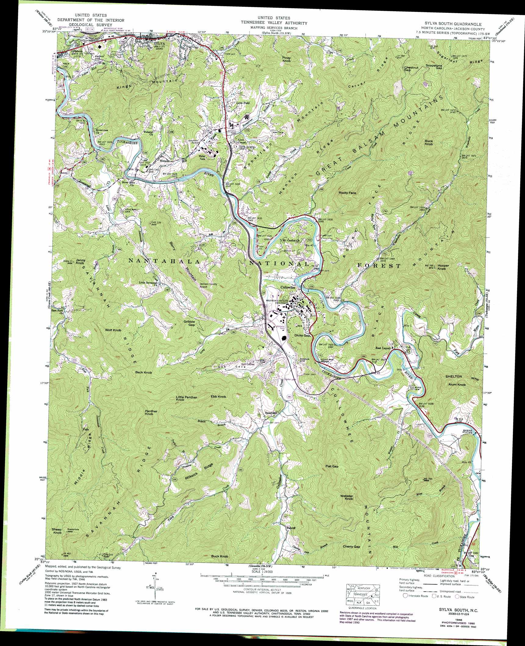
USGS Topo Quad 35083c2 - 1:24,000 scale
| Topo Map Name: | Sylva South |
| USGS Topo Quad ID: | 35083c2 |
| Print Size: | ca. 21 1/4" wide x 27" high |
| Southeast Coordinates: | 35.25° N latitude / 83.125° W longitude |
| Map Center Coordinates: | 35.3125° N latitude / 83.1875° W longitude |
| U.S. State: | NC |
| Filename: | o35083c2.jpg |
| Download Map JPG Image: | Sylva South topo map 1:24,000 scale |
| Map Type: | Topographic |
| Topo Series: | 7.5´ |
| Map Scale: | 1:24,000 |
| Source of Map Images: | United States Geological Survey (USGS) |
| Alternate Map Versions: |
Cullowhee NC 1935 Download PDF Buy paper map Cullowhee NC 1946, updated 1947 Download PDF Buy paper map Cullowhee NC 1946, updated 1947 Download PDF Buy paper map Cullowhee NC 1946, updated 1958 Download PDF Buy paper map Cullowhee NC 1946, updated 1966 Download PDF Buy paper map Sylva South NC 1946, updated 1972 Download PDF Buy paper map Sylva South NC 1946, updated 1978 Download PDF Buy paper map Sylva South NC 1946, updated 1988 Download PDF Buy paper map Sylva South NC 1946, updated 1990 Download PDF Buy paper map Sylva South NC 2000, updated 2001 Download PDF Buy paper map Sylva South NC 2011 Download PDF Buy paper map Sylva South NC 2013 Download PDF Buy paper map Sylva South NC 2016 Download PDF Buy paper map |
| FStopo: | US Forest Service topo Sylva South is available: Download FStopo PDF Download FStopo TIF |
1:24,000 Topo Quads surrounding Sylva South
Clingmans Dome |
Smokemont |
Bunches Bald |
Dellwood |
Clyde |
Bryson City |
Whittier |
Sylva North |
Hazelwood |
Waynesville |
Alarka |
Greens Creek |
Sylva South |
Tuckasegee |
Sam Knob |
Franklin |
Corbin Knob |
Glenville |
Big Ridge |
Lake Toxaway |
Prentiss |
Scaly Mountain |
Highlands |
Cashiers |
Reid |
> Back to 35083a1 at 1:100,000 scale
> Back to 35082a1 at 1:250,000 scale
> Back to U.S. Topo Maps home
Sylva South topo map: Gazetteer
Sylva South: Airports
Jackson County Airport elevation 862m 2828′Sylva South: Bridges
Dicks Gap Bridge elevation 634m 2080′Sylva South: Dams
Dillsboro Dam elevation 599m 1965′Frady Cove Dam elevation 717m 2352′
Hodge Dam elevation 969m 3179′
McGuire Lake Dam elevation 954m 3129′
Sylva South: Gaps
Cherry Gap elevation 1220m 4002′Chestnut Gap elevation 969m 3179′
Dicks Gap elevation 681m 2234′
Flat Gap elevation 1087m 3566′
Gribble Gap elevation 778m 2552′
Soapstone Gap elevation 1083m 3553′
Sylva South: Populated Places
Cullowhee elevation 645m 2116′East Laport elevation 650m 2132′
Fallcliff elevation 689m 2260′
Forest Hills elevation 701m 2299′
Love Field elevation 653m 2142′
Speedwell elevation 663m 2175′
Sylva elevation 623m 2043′
Webster elevation 656m 2152′
Sylva South: Reservoirs
Frady Cove Lake elevation 717m 2352′Hodge Lake elevation 969m 3179′
Lake Dillsboro elevation 599m 1965′
McGuire Lake elevation 954m 3129′
Sylva South: Ridges
Carver Ridge elevation 1047m 3435′Cullowhee Mountain elevation 1281m 4202′
Henson Ridge elevation 877m 2877′
Middle Ridge elevation 1162m 3812′
Milksick Ridge elevation 881m 2890′
Rocky Face Ridge elevation 1026m 3366′
Savannah Ridge elevation 1214m 3982′
Sylva South: Streams
Ash Branch elevation 620m 2034′Blake Branch elevation 623m 2043′
Bryson Branch elevation 662m 2171′
Bumgarner Branch elevation 643m 2109′
Cagle Branch elevation 629m 2063′
Cane Creek elevation 625m 2050′
Caney Fork elevation 643m 2109′
Cherry Gap Branch elevation 684m 2244′
Cope Creek elevation 623m 2043′
Cox Branch elevation 640m 2099′
Cullowhee Creek elevation 628m 2060′
John Brown Branch elevation 652m 2139′
Little Savannah Creek elevation 616m 2020′
Locust Creek elevation 621m 2037′
Long Branch elevation 639m 2096′
Mill Creek elevation 655m 2148′
Mill Creek elevation 612m 2007′
Mine Branch elevation 649m 2129′
Moses Creek elevation 670m 2198′
Parker Branch elevation 740m 2427′
Pressley Creek elevation 666m 2185′
Rocky Face Branch elevation 680m 2230′
Savannah Creek elevation 608m 1994′
Tilley Creek elevation 655m 2148′
Wayehutta Creek elevation 631m 2070′
Webster Creek elevation 645m 2116′
Yellow Bird Branch elevation 604m 1981′
Sylva South: Summits
Alum Knob elevation 945m 3100′Beck Knob elevation 1044m 3425′
Berry Mountain elevation 868m 2847′
Buck Knob elevation 1239m 4064′
Buck Knob elevation 1217m 3992′
Ebb Knob elevation 1022m 3353′
Hooper Knob elevation 1130m 3707′
Jenny Knob elevation 893m 2929′
Kings Mountain elevation 959m 3146′
Little Panther Knob elevation 1108m 3635′
Panther Knob elevation 1258m 4127′
Piney Knob elevation 932m 3057′
Robertson Mountain elevation 1024m 3359′
Rocky Face elevation 1088m 3569′
Sheep Knob elevation 1420m 4658′
Webster Knob elevation 1239m 4064′
Wolf Knob elevation 1027m 3369′
Sylva South: Valleys
Bart Cove elevation 606m 1988′Cox Cove elevation 644m 2112′
Dills Cove elevation 614m 2014′
Monteith Cove elevation 612m 2007′
Sylva South digital topo map on disk
Buy this Sylva South topo map showing relief, roads, GPS coordinates and other geographical features, as a high-resolution digital map file on DVD:
South Carolina, Western North Carolina & Northeastern Georgia
Buy digital topo maps: South Carolina, Western North Carolina & Northeastern Georgia