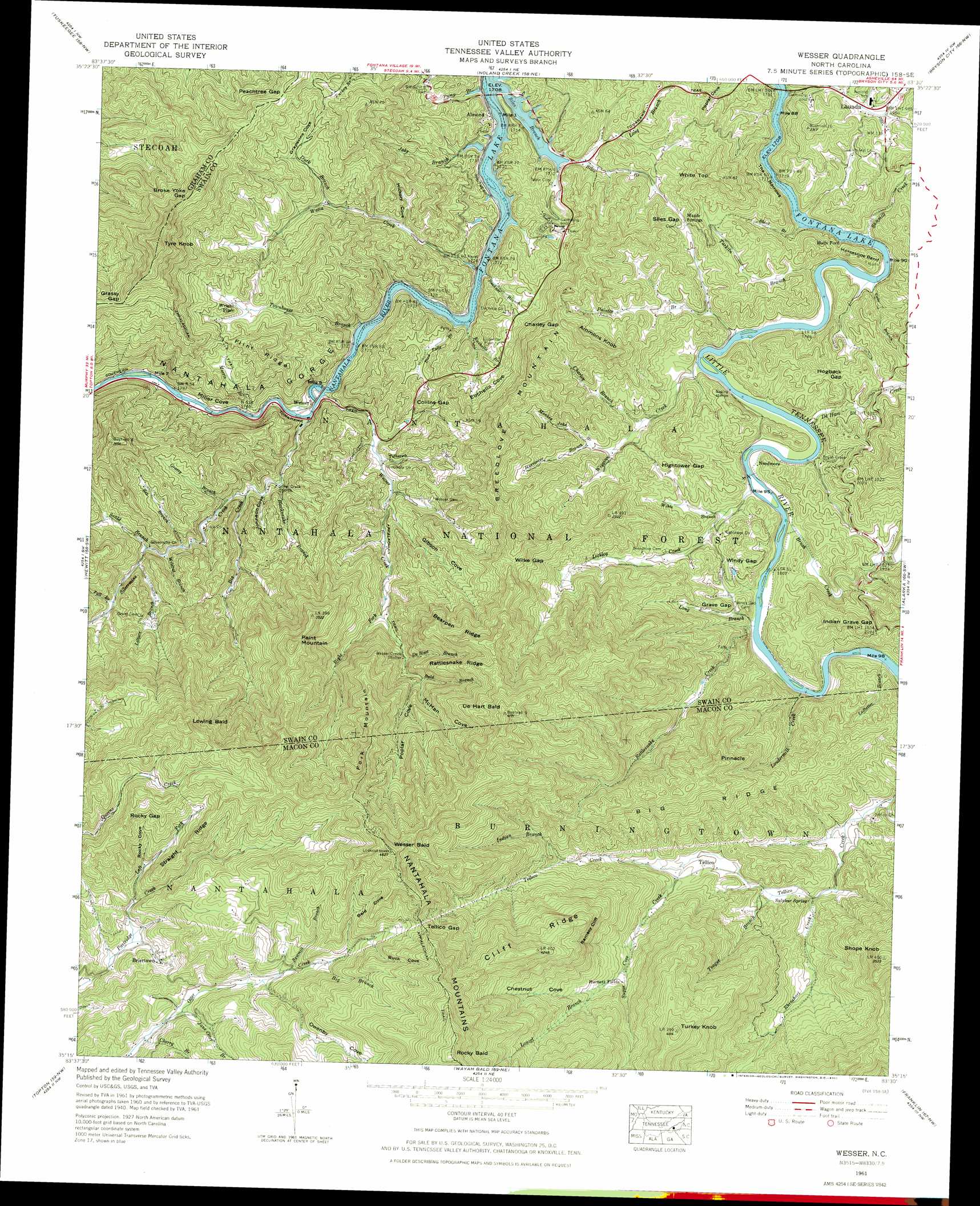
Wesser Topo Map North Carolina
To zoom in, hover over the map of Wesser
USGS Topo Quad 35083c5 - 1:24,000 scale
| Topo Map Name: | Wesser |
| USGS Topo Quad ID: | 35083c5 |
| Print Size: | ca. 21 1/4" wide x 27" high |
| Southeast Coordinates: | 35.25° N latitude / 83.5° W longitude |
| Map Center Coordinates: | 35.3125° N latitude / 83.5625° W longitude |
| U.S. State: | NC |
| Filename: | o35083c5.jpg |
| Download Map JPG Image: | Wesser topo map 1:24,000 scale |
| Map Type: | Topographic |
| Topo Series: | 7.5´ |
| Map Scale: | 1:24,000 |
| Source of Map Images: | United States Geological Survey (USGS) |
| Alternate Map Versions: |
Wesser NC 1936 Download PDF Buy paper map Wesser NC 1940 Download PDF Buy paper map Wesser NC 1940, updated 1957 Download PDF Buy paper map Wesser NC 1961, updated 1965 Download PDF Buy paper map Wesser NC 1961, updated 1972 Download PDF Buy paper map Wesser NC 1961, updated 1991 Download PDF Buy paper map Wesser NC 1961, updated 1991 Download PDF Buy paper map Wesser NC 1976, updated 1976 Download PDF Buy paper map Wesser NC 2011 Download PDF Buy paper map Wesser NC 2013 Download PDF Buy paper map Wesser NC 2016 Download PDF Buy paper map |
| FStopo: | US Forest Service topo Wesser is available: Download FStopo PDF Download FStopo TIF |
1:24,000 Topo Quads surrounding Wesser
Cades Cove |
Thunderhead Mountain |
Silers Bald |
Clingmans Dome |
Smokemont |
Fontana Dam |
Tuskeegee |
Noland Creek |
Bryson City |
Whittier |
Robbinsville |
Hewitt |
Wesser |
Alarka |
Greens Creek |
Andrews |
Topton |
Wayah Bald |
Franklin |
Corbin Knob |
Hayesville |
Shooting Creek |
Rainbow Springs |
Prentiss |
Scaly Mountain |
> Back to 35083a1 at 1:100,000 scale
> Back to 35082a1 at 1:250,000 scale
> Back to U.S. Topo Maps home
Wesser topo map: Gazetteer
Wesser: Bends
Horseshoe Bend elevation 588m 1929′Wesser: Cliffs
Ramsey Cliff elevation 1084m 3556′Wesser: Gaps
Broke Yoke Gap elevation 1008m 3307′Charley Gap elevation 780m 2559′
Collins Gap elevation 639m 2096′
Grassy Gap elevation 925m 3034′
Grave Gap elevation 589m 1932′
Hightower Gap elevation 643m 2109′
Hogback Gap elevation 644m 2112′
Indian Grave Gap elevation 667m 2188′
Peachtree Gap elevation 825m 2706′
Rocky Gap elevation 1117m 3664′
Siles Gap elevation 633m 2076′
Tellico Gap elevation 1177m 3861′
Wilke Gap elevation 962m 3156′
Windy Gap elevation 616m 2020′
Wesser: Populated Places
Almond elevation 525m 1722′Briertown elevation 911m 2988′
Burnett Fields elevation 847m 2778′
Halls Ford elevation 519m 1702′
Lauada elevation 597m 1958′
Maple Springs elevation 651m 2135′
Needmore elevation 545m 1788′
Tellico elevation 674m 2211′
Wesser elevation 525m 1722′
Wright Place elevation 690m 2263′
Wesser: Ridges
Bearpen Ridge elevation 1064m 3490′Big Ridge elevation 978m 3208′
Cliff Ridge elevation 1307m 4288′
Flint Ridge elevation 838m 2749′
Rattlesnake Ridge elevation 1017m 3336′
Straight Ridge elevation 1082m 3549′
Wesser: Springs
Sulphur Spring elevation 640m 2099′Wesser: Streams
Bald Branch elevation 789m 2588′Bee Branch elevation 623m 2043′
Big Branch elevation 1003m 3290′
Big Creek elevation 576m 1889′
Bird Falls Branch elevation 513m 1683′
Blacksnake Branch elevation 552m 1811′
Brush Creek elevation 546m 1791′
Buckner Branch elevation 513m 1683′
Cabe Branch elevation 524m 1719′
Charley Branch elevation 571m 1873′
Cherry Branch elevation 867m 2844′
DeHart Branch elevation 743m 2437′
DeHart Creek elevation 540m 1771′
Duck Branch elevation 610m 2001′
Euchella Branch elevation 518m 1699′
Fall Branch elevation 684m 2244′
Grassy Branch elevation 590m 1935′
Hurricane Branch elevation 614m 2014′
Indian Branch elevation 800m 2624′
Jake Branch elevation 512m 1679′
Jane Otter Branch elevation 882m 2893′
Laurel Branch elevation 828m 2716′
Ledbetter Branch elevation 562m 1843′
Left Fork Partridge Creek elevation 901m 2956′
Lettuce Branch elevation 667m 2188′
Licklog Creek elevation 546m 1791′
Long Branch elevation 525m 1722′
Long Branch elevation 554m 1817′
Loudermilk Creek elevation 557m 1827′
Monkey John Branch elevation 592m 1942′
Morris Branch elevation 532m 1745′
Painter Branch elevation 533m 1748′
Pump Branch elevation 519m 1702′
Rattlesnake Creek elevation 551m 1807′
Rhinehart Creek elevation 624m 2047′
Right Fork Wesser Creek elevation 672m 2204′
Sawmill Branch elevation 955m 3133′
Sawmill Creek elevation 523m 1715′
Scald Branch elevation 643m 2109′
Short Branch elevation 520m 1706′
Silvermine Creek elevation 526m 1725′
Stiles Branch elevation 511m 1676′
Sugar Cove Creek elevation 688m 2257′
Tarkiln Branch elevation 530m 1738′
Teague Branch elevation 639m 2096′
Totherow Branch elevation 571m 1873′
Townhouse Branch elevation 520m 1706′
Watia Creek elevation 519m 1702′
Wesser Creek elevation 518m 1699′
Wiggins Creek elevation 538m 1765′
Wikle Branch elevation 563m 1847′
Wildcat Branch elevation 632m 2073′
Wesser: Summits
Ammons Knob elevation 833m 2732′Breedlove Mountain elevation 1006m 3300′
DeHart Bald elevation 1258m 4127′
Fork Mountain elevation 1261m 4137′
Lowing Bald elevation 1321m 4333′
Paint Mountain elevation 1132m 3713′
Pinnacle elevation 955m 3133′
Rocky Bald elevation 1543m 5062′
Shope Knob elevation 1068m 3503′
Turkey Knob elevation 1236m 4055′
Tyre Knob elevation 1142m 3746′
Wesser Bald elevation 1409m 4622′
White Top elevation 812m 2664′
Wesser: Trails
Wesser Creek Trail elevation 891m 2923′Wesser: Valleys
Bald Cove elevation 1030m 3379′Buck Cove elevation 1068m 3503′
Chestnut Cove elevation 877m 2877′
Euchella Cove elevation 560m 1837′
Gibson Cove elevation 595m 1952′
Grapevine Cove elevation 610m 2001′
Hickory Cove elevation 560m 1837′
Johnson Cove elevation 561m 1840′
McHan Cove elevation 804m 2637′
Miller Cove elevation 531m 1742′
Nantahala Gorge elevation 511m 1676′
Owenby Cove elevation 928m 3044′
Poplar Cove elevation 804m 2637′
Rocky Cove elevation 956m 3136′
The Narrows elevation 511m 1676′
Wesser digital topo map on disk
Buy this Wesser topo map showing relief, roads, GPS coordinates and other geographical features, as a high-resolution digital map file on DVD:
South Carolina, Western North Carolina & Northeastern Georgia
Buy digital topo maps: South Carolina, Western North Carolina & Northeastern Georgia