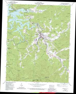
Robbinsville Topo Map North Carolina
To zoom in, hover over the map of Robbinsville
USGS Topo Quad 35083c7 - 1:24,000 scale
| Topo Map Name: | Robbinsville |
| USGS Topo Quad ID: | 35083c7 |
| Print Size: | ca. 21 1/4" wide x 27" high |
| Southeast Coordinates: | 35.25° N latitude / 83.75° W longitude |
| Map Center Coordinates: | 35.3125° N latitude / 83.8125° W longitude |
| U.S. State: | NC |
| Filename: | o35083c7.jpg |
| Download Map JPG Image: | Robbinsville topo map 1:24,000 scale |
| Map Type: | Topographic |
| Topo Series: | 7.5´ |
| Map Scale: | 1:24,000 |
| Source of Map Images: | United States Geological Survey (USGS) |
| Alternate Map Versions: |
Robbinsville NC 1935 Download PDF Buy paper map Robbinsville NC 1940 Download PDF Buy paper map Robbinsville NC 1940, updated 1957 Download PDF Buy paper map Robbinsville NC 1940, updated 1963 Download PDF Buy paper map Robbinsville NC 1940, updated 1968 Download PDF Buy paper map Robbinsville NC 1940, updated 1975 Download PDF Buy paper map Robbinsville NC 1940, updated 1984 Download PDF Buy paper map Robbinsville NC 1940, updated 1991 Download PDF Buy paper map Robbinsville NC 1940, updated 1991 Download PDF Buy paper map Robbinsville NC 1976, updated 1978 Download PDF Buy paper map Robbinsville NC 2000, updated 2001 Download PDF Buy paper map Robbinsville NC 2011 Download PDF Buy paper map Robbinsville NC 2013 Download PDF Buy paper map Robbinsville NC 2016 Download PDF Buy paper map |
| FStopo: | US Forest Service topo Robbinsville is available: Download FStopo PDF Download FStopo TIF |
1:24,000 Topo Quads surrounding Robbinsville
> Back to 35083a1 at 1:100,000 scale
> Back to 35082a1 at 1:250,000 scale
> Back to U.S. Topo Maps home
Robbinsville topo map: Gazetteer
Robbinsville: Airports
Phillips Airport elevation 629m 2063′Robbinsville: Areas
17 Land Tract elevation 724m 2375′373 Land Tract elevation 634m 2080′
477 Land Tract elevation 635m 2083′
588 Land Tract elevation 830m 2723′
589 Land Tract elevation 899m 2949′
91 Land Tract elevation 658m 2158′
93 Land Tract elevation 605m 1984′
John Teeseteska 367,404,405 Land Tract elevation 717m 2352′
Upper Cornsilk 374 Land Tract elevation 683m 2240′
Robbinsville: Basins
Sammy Basin elevation 805m 2641′Seb Basin elevation 937m 3074′
Robbinsville: Dams
Leonard Phillips Dam elevation 632m 2073′Robbinsville: Gaps
Atoah Gap elevation 942m 3090′Barker Road Gap elevation 1194m 3917′
Brooks Gap elevation 624m 2047′
Deep Gap elevation 1043m 3421′
Green Gap elevation 1015m 3330′
Henry Gap elevation 860m 2821′
Hickory Gap elevation 798m 2618′
Highland Gap elevation 668m 2191′
I U Gap elevation 734m 2408′
Mauney Gap elevation 719m 2358′
Shanty Gap elevation 805m 2641′
Snowbird Gap elevation 661m 2168′
Tatham Gap elevation 1112m 3648′
Tucker Gap elevation 675m 2214′
Water Gap elevation 1020m 3346′
Robbinsville: Populated Places
Lake Santeetlah elevation 605m 1984′Milltown elevation 645m 2116′
Robbinsville elevation 624m 2047′
Sweetgum elevation 658m 2158′
Tulula elevation 718m 2355′
Robbinsville: Post Offices
Robbinsville Post Office elevation 607m 1991′Robbinsville: Reservoirs
Leonard Phillips Lake elevation 632m 2073′Robbinsville: Ridges
Horse Range Ridge elevation 1089m 3572′Teeseteska Ridge elevation 992m 3254′
The Hog Back elevation 812m 2664′
Robbinsville: Streams
Anderson Creek elevation 689m 2260′Atoah Creek elevation 623m 2043′
Auntney Branch elevation 709m 2326′
Barker Branch elevation 589m 1932′
Beech Creek elevation 665m 2181′
Bert Creek elevation 665m 2181′
Burgan Creek elevation 755m 2477′
Campbell Creek elevation 707m 2319′
Carpenter Branch elevation 702m 2303′
Cooloska Branch elevation 597m 1958′
Cornsilk Branch elevation 630m 2066′
Davis Branch elevation 659m 2162′
East Buffalo Creek elevation 590m 1935′
Eller Mill Creek elevation 711m 2332′
Fox Squirrel Branch elevation 687m 2253′
Franks Creek elevation 646m 2119′
Green Creek elevation 734m 2408′
Ground Squirrel Branch elevation 591m 1938′
Hares Creek elevation 695m 2280′
Harwood Branch elevation 643m 2109′
Holloway Branch elevation 639m 2096′
Holly Cove Branch elevation 660m 2165′
Hooper Branch elevation 593m 1945′
Hunting Boy Branch elevation 667m 2188′
Jake Branch elevation 672m 2204′
Long Branch elevation 618m 2027′
Long Branch elevation 646m 2119′
Long Creek elevation 600m 1968′
Long Hungry Branch elevation 590m 1935′
Massey Branch elevation 589m 1932′
Mauney Branch elevation 603m 1978′
Mill Creek elevation 635m 2083′
Millpon Creek elevation 674m 2211′
Moose Branch elevation 612m 2007′
Mountain Creek elevation 591m 1938′
Ollie Creek elevation 590m 1935′
Panther Creek elevation 798m 2618′
Pigpen Branch elevation 648m 2125′
Pinhook Branch elevation 604m 1981′
Pinhook Branch elevation 668m 2191′
Poison Branch elevation 647m 2122′
Riley Branch elevation 631m 2070′
Rock Creek elevation 727m 2385′
Ryefield Branch elevation 591m 1938′
Shepherd Creek elevation 645m 2116′
Slay Bacon Branch elevation 632m 2073′
Snowbird Creek elevation 589m 1932′
Stillhouse Branch elevation 661m 2168′
Sweetwater Creek elevation 604m 1981′
Tahquette Branch elevation 632m 2073′
Tulula Creek elevation 604m 1981′
West Buffalo Creek elevation 589m 1932′
Wiggins Mill Branch elevation 623m 2043′
Robbinsville: Summits
Cooper Knob elevation 930m 3051′Dobson Hill elevation 693m 2273′
Eagle Knob elevation 923m 3028′
Pinnacle Knob elevation 803m 2634′
Teyahalee Bald elevation 1435m 4708′
Robbinsville: Valleys
Eller Cove elevation 778m 2552′Shope Cove elevation 748m 2454′
Stillhouse Hollow elevation 596m 1955′
Robbinsville digital topo map on disk
Buy this Robbinsville topo map showing relief, roads, GPS coordinates and other geographical features, as a high-resolution digital map file on DVD:
South Carolina, Western North Carolina & Northeastern Georgia
Buy digital topo maps: South Carolina, Western North Carolina & Northeastern Georgia


