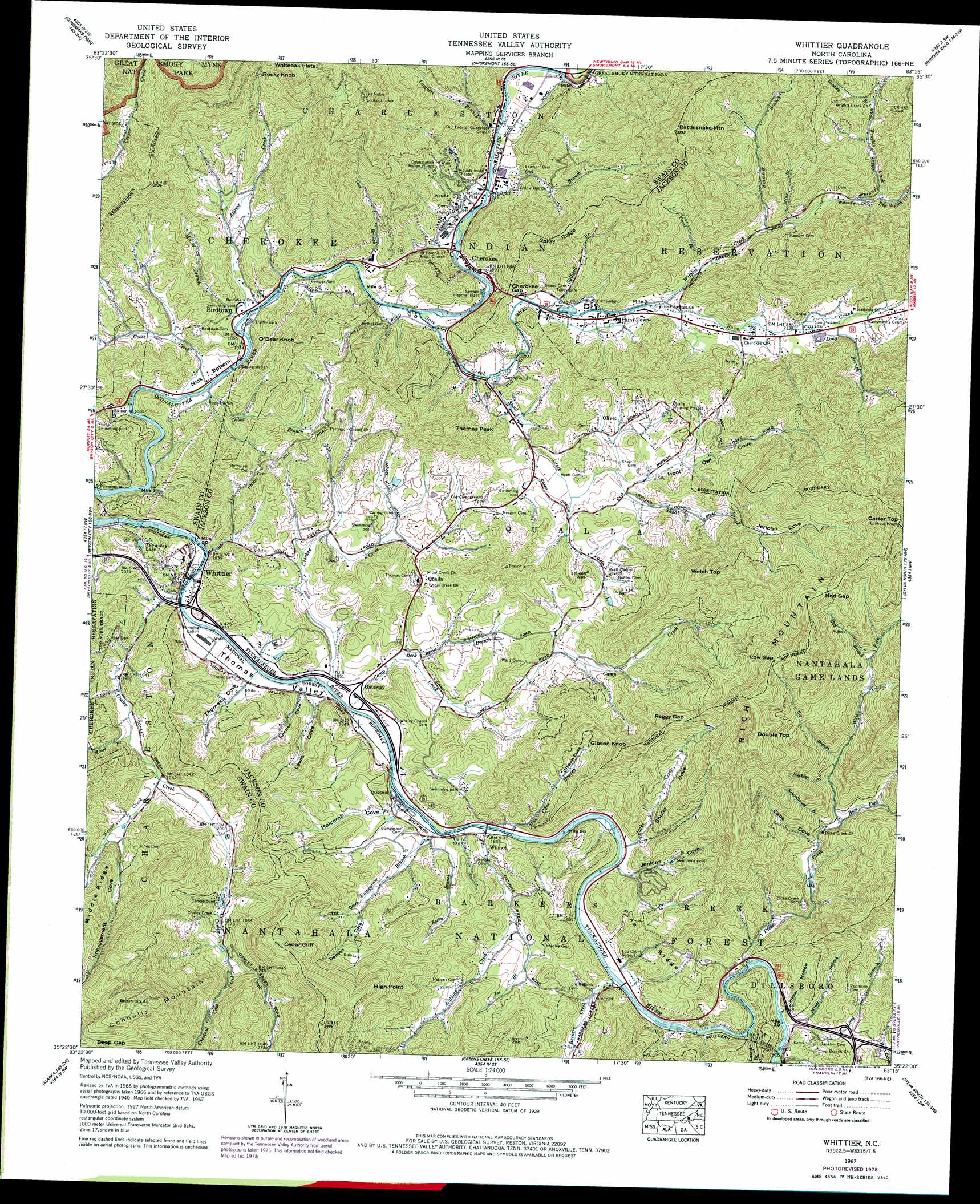
Whittier Topo Map North Carolina
To zoom in, hover over the map of Whittier
USGS Topo Quad 35083d3 - 1:24,000 scale
| Topo Map Name: | Whittier |
| USGS Topo Quad ID: | 35083d3 |
| Print Size: | ca. 21 1/4" wide x 27" high |
| Southeast Coordinates: | 35.375° N latitude / 83.25° W longitude |
| Map Center Coordinates: | 35.4375° N latitude / 83.3125° W longitude |
| U.S. State: | NC |
| Filename: | o35083d3.jpg |
| Download Map JPG Image: | Whittier topo map 1:24,000 scale |
| Map Type: | Topographic |
| Topo Series: | 7.5´ |
| Map Scale: | 1:24,000 |
| Source of Map Images: | United States Geological Survey (USGS) |
| Alternate Map Versions: |
Whittier NC 1936 Download PDF Buy paper map Whittier NC 1940 Download PDF Buy paper map Whittier NC 1940, updated 1957 Download PDF Buy paper map Whittier NC 1941 Download PDF Buy paper map Whittier NC 1941 Download PDF Buy paper map Whittier NC 1967, updated 1970 Download PDF Buy paper map Whittier NC 1967, updated 1974 Download PDF Buy paper map Whittier NC 1967, updated 1979 Download PDF Buy paper map Whittier NC 1967, updated 1990 Download PDF Buy paper map Whittier NC 1967, updated 1990 Download PDF Buy paper map Whittier NC 2011 Download PDF Buy paper map Whittier NC 2013 Download PDF Buy paper map Whittier NC 2016 Download PDF Buy paper map |
| FStopo: | US Forest Service topo Whittier is available: Download FStopo PDF Download FStopo TIF |
1:24,000 Topo Quads surrounding Whittier
Gatlinburg |
Mount Le Conte |
Mount Guyot |
Luftee Knob |
Cove Creek Gap |
Silers Bald |
Clingmans Dome |
Smokemont |
Bunches Bald |
Dellwood |
Noland Creek |
Bryson City |
Whittier |
Sylva North |
Hazelwood |
Wesser |
Alarka |
Greens Creek |
Sylva South |
Tuckasegee |
Wayah Bald |
Franklin |
Corbin Knob |
Glenville |
Big Ridge |
> Back to 35083a1 at 1:100,000 scale
> Back to 35082a1 at 1:250,000 scale
> Back to U.S. Topo Maps home
Whittier topo map: Gazetteer
Whittier: Bends
Nick Bottom elevation 564m 1850′Whittier: Dams
Homer Burgess Dam elevation 603m 1978′Whittier: Gaps
Cherokee Gap elevation 629m 2063′Deep Gap elevation 1065m 3494′
Low Gap elevation 1141m 3743′
Ned Gap elevation 1152m 3779′
Peggy Gap elevation 902m 2959′
Whiteoak Flats elevation 1066m 3497′
Whittier: Parks
Frontierland elevation 617m 2024′Santa's Land elevation 656m 2152′
Whittier: Populated Places
Birdtown elevation 568m 1863′Cherokee elevation 605m 1984′
Indian Hills elevation 609m 1998′
Oconaluftee Indian Village elevation 657m 2155′
Olivet elevation 641m 2103′
Paint Town elevation 621m 2037′
Qualla elevation 618m 2027′
Whittier elevation 561m 1840′
Wilmot elevation 584m 1916′
Whittier: Reservoirs
Homer Burgess Lake elevation 603m 1978′Oconaluftee Lake elevation 554m 1817′
Tuc-a-way Lake elevation 600m 1968′
Whittier: Ridges
Middle Ridge elevation 908m 2979′Pine Ridge elevation 668m 2191′
Spray Ridge elevation 801m 2627′
Whittier: Streams
Adams Creek elevation 566m 1856′Barkers Creek elevation 574m 1883′
Beck Branch elevation 572m 1876′
Big Branch elevation 761m 2496′
Big Witch Creek elevation 749m 2457′
Bradley Branch elevation 827m 2713′
Buckeye Branch elevation 728m 2388′
Bumgarner Branch elevation 563m 1847′
Camp Creek elevation 566m 1856′
Cane Branch elevation 565m 1853′
Chestnut Cove Creek elevation 686m 2250′
Connelly Creek elevation 559m 1833′
Crooked Creek elevation 563m 1847′
Deep Gap Branch elevation 860m 2821′
Dicks Creek elevation 585m 1919′
East Fork Dicks Creek elevation 677m 2221′
Gibbs Branch elevation 565m 1853′
Goose Creek elevation 560m 1837′
Improvement Creek elevation 625m 2050′
Jacks Creek elevation 573m 1879′
Joe Branch elevation 616m 2020′
Lambert Branch elevation 599m 1965′
Laurel Branch elevation 580m 1902′
Long Branch elevation 650m 2132′
Long Branch elevation 592m 1942′
Mainey Branch elevation 845m 2772′
McCoy Branch elevation 566m 1856′
Mince Branch elevation 626m 2053′
Mink Branch elevation 698m 2290′
Moore Branch elevation 591m 1938′
Nations Creek elevation 564m 1850′
Ned Branch elevation 908m 2979′
Owl Branch elevation 594m 1948′
Owl Branch elevation 610m 2001′
Rocky Branch elevation 574m 1883′
Schoolhouse Branch elevation 671m 2201′
Shoal Creek elevation 592m 1942′
Soco Creek elevation 583m 1912′
Stillwell Branch elevation 609m 1998′
Swimmer Branch elevation 682m 2237′
Tooni Branch elevation 646m 2119′
Wesser Creek elevation 604m 1981′
West Fork Dicks Creek elevation 676m 2217′
Williams Branch elevation 653m 2142′
Wrights Creek elevation 624m 2047′
Whittier: Summits
Carter Top elevation 1294m 4245′Cedar Cliff elevation 1000m 3280′
Connelly Mountain elevation 1212m 3976′
Double Top elevation 1199m 3933′
Gibson Knob elevation 905m 2969′
High Point elevation 1008m 3307′
O'Dear Knob elevation 765m 2509′
Rattlesnake Mountain elevation 1130m 3707′
Rich Mountain elevation 1274m 4179′
Rocky Knob elevation 1059m 3474′
Thomas Peak elevation 818m 2683′
Welch Top elevation 981m 3218′
Whittier: Tunnels
Cowee Tunnel elevation 683m 2240′Whittier: Valleys
Cabe Cove elevation 657m 2155′Denton Cove elevation 613m 2011′
Gibson Cove elevation 626m 2053′
Hazel Hollow elevation 592m 1942′
Holcomb Cove elevation 562m 1843′
Hoot Owl Cove elevation 625m 2050′
Improvement Cove elevation 625m 2050′
Jenkins Cove elevation 572m 1876′
Jericho Cove elevation 678m 2224′
Kitchen Cove elevation 562m 1843′
Lewis Cove elevation 561m 1840′
Shuler Cove elevation 575m 1886′
Thomas Cove elevation 559m 1833′
Thomas Valley elevation 558m 1830′
Till Cove elevation 641m 2103′
Whittier digital topo map on disk
Buy this Whittier topo map showing relief, roads, GPS coordinates and other geographical features, as a high-resolution digital map file on DVD:
South Carolina, Western North Carolina & Northeastern Georgia
Buy digital topo maps: South Carolina, Western North Carolina & Northeastern Georgia