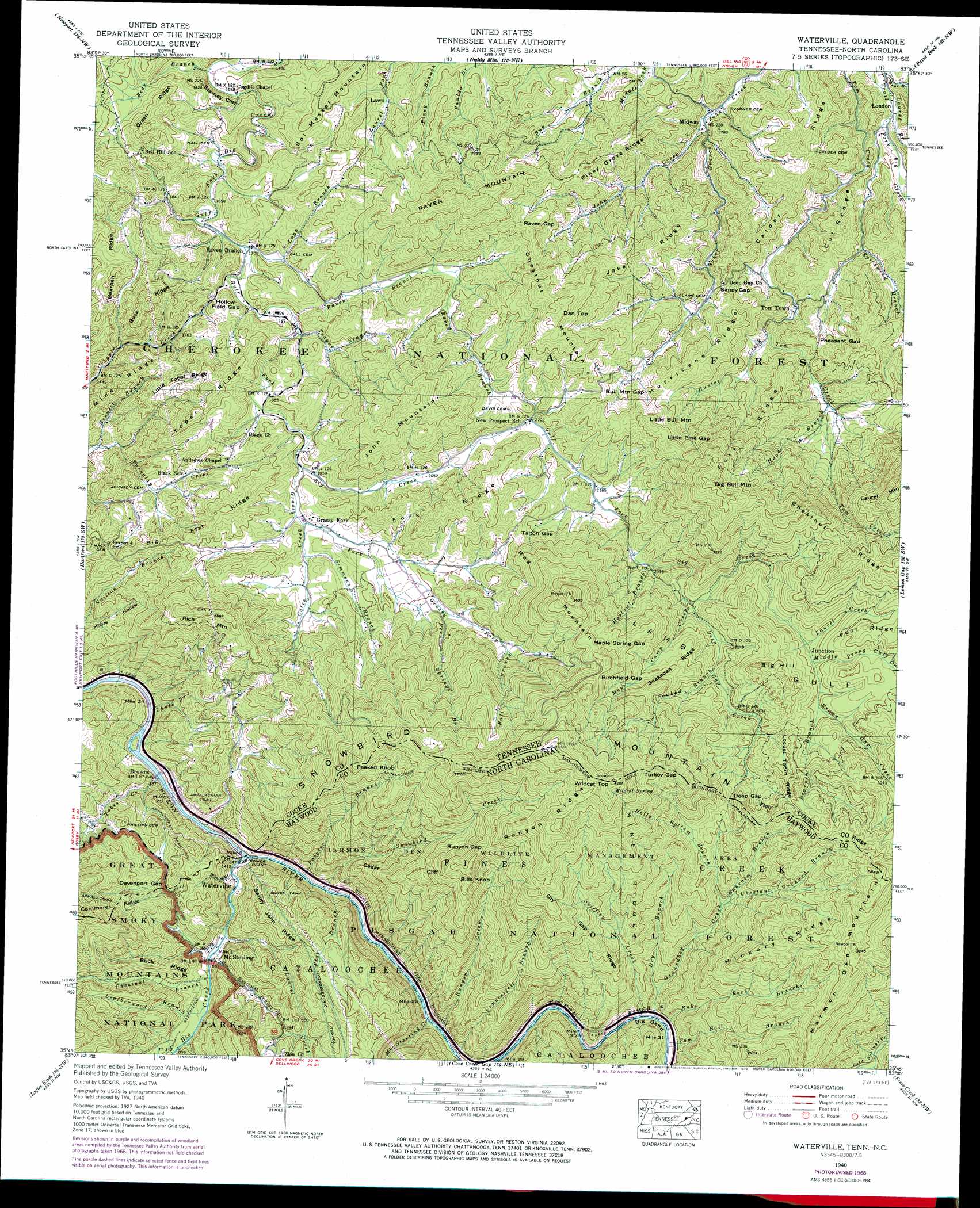
Waterville Topo Map Tennessee
To zoom in, hover over the map of Waterville
USGS Topo Quad 35083g1 - 1:24,000 scale
| Topo Map Name: | Waterville |
| USGS Topo Quad ID: | 35083g1 |
| Print Size: | ca. 21 1/4" wide x 27" high |
| Southeast Coordinates: | 35.75° N latitude / 83° W longitude |
| Map Center Coordinates: | 35.8125° N latitude / 83.0625° W longitude |
| U.S. States: | TN, NC |
| Filename: | o35083g1.jpg |
| Download Map JPG Image: | Waterville topo map 1:24,000 scale |
| Map Type: | Topographic |
| Topo Series: | 7.5´ |
| Map Scale: | 1:24,000 |
| Source of Map Images: | United States Geological Survey (USGS) |
| Alternate Map Versions: |
Waterville NC 1936 Download PDF Buy paper map Waterville NC 1940 Download PDF Buy paper map Waterville NC 1940, updated 1957 Download PDF Buy paper map Waterville NC 1940, updated 1961 Download PDF Buy paper map Waterville NC 1940, updated 1971 Download PDF Buy paper map Waterville NC 1940, updated 1974 Download PDF Buy paper map Waterville NC 1940, updated 1974 Download PDF Buy paper map Waterville NC 2003, updated 2004 Download PDF Buy paper map Waterville NC 2011 Download PDF Buy paper map Waterville NC 2013 Download PDF Buy paper map Waterville NC 2016 Download PDF Buy paper map |
| FStopo: | US Forest Service topo Waterville is available: Download FStopo PDF Download FStopo TIF |
1:24,000 Topo Quads surrounding Waterville
White Pine |
Rankin |
Parrotsville |
Cedar Creek |
Davy Crockett Lake |
Chestnut Hill |
Newport |
Neddy Mountain |
Paint Rock |
Hot Springs |
Jones Cove |
Hartford |
Waterville |
Lemon Gap |
Spring Creek |
Mount Guyot |
Luftee Knob |
Cove Creek Gap |
Fines Creek |
Sandymush |
Smokemont |
Bunches Bald |
Dellwood |
Clyde |
Canton |
> Back to 35083e1 at 1:100,000 scale
> Back to 35082a1 at 1:250,000 scale
> Back to U.S. Topo Maps home
Waterville topo map: Gazetteer
Waterville: Bends
Big Bend elevation 608m 1994′Waterville: Cliffs
Stanley Cliff elevation 500m 1640′Waterville: Crossings
Interchange 451 elevation 435m 1427′Waterville: Forests
Cherokee National Forest elevation 693m 2273′Waterville: Gaps
Birchfield Gap elevation 1037m 3402′Bull Mountain Gap elevation 712m 2335′
Davenport Gap elevation 611m 2004′
Davenport Gap elevation 609m 1998′
Deep Gap elevation 885m 2903′
Deep Gap elevation 888m 2913′
Hollow Field Gap elevation 562m 1843′
Little Pine Gap elevation 807m 2647′
Maple Spring Gap elevation 987m 3238′
Pheasant Gap elevation 621m 2037′
Raven Gap elevation 698m 2290′
Runyon Gap elevation 1012m 3320′
Sandy Gap elevation 595m 1952′
Talton Gap elevation 771m 2529′
Turkey Gap elevation 1085m 3559′
Turkey Gap elevation 1127m 3697′
Waterville: Populated Places
Browns elevation 432m 1417′Crestmont elevation 531m 1742′
Grassy Fork elevation 619m 2030′
London elevation 443m 1453′
Midway elevation 459m 1505′
Mount Sterling elevation 473m 1551′
Naillon (historical) elevation 597m 1958′
Raven Branch elevation 523m 1715′
Tom Town elevation 522m 1712′
Waterville elevation 446m 1463′
Waterville: Ridges
Bearpen Ridge elevation 592m 1942′Bearpen Ridge elevation 615m 2017′
Big Flat Ridge elevation 687m 2253′
Buck Ridge elevation 675m 2214′
Buck Ridge elevation 629m 2063′
Calder Ridge elevation 564m 1850′
Calder Ridge elevation 572m 1876′
Cedar Cliff elevation 836m 2742′
Chestnut Ridge elevation 1027m 3369′
Cut Ridge elevation 587m 1925′
Dry Gap Ridge elevation 910m 2985′
Flat Ridge elevation 1047m 3435′
Flat Ridge elevation 1064m 3490′
Fork Ridge elevation 741m 2431′
Green Ridge elevation 659m 2162′
Hickory Ridge elevation 1025m 3362′
Hurricane Ridge elevation 680m 2230′
Jake Ridge elevation 721m 2365′
Little Toper Ridge elevation 599m 1965′
Locust Thorn Ridge elevation 917m 3008′
Mine Ridge elevation 548m 1797′
Mine Ridge elevation 967m 3172′
Mine Ridge elevation 573m 1879′
Piney Grove Ridge elevation 657m 2155′
Runyon Ridge elevation 1212m 3976′
Sandy John Ridge elevation 636m 2086′
Snakeden Ridge elevation 851m 2791′
Toper Ridge elevation 668m 2191′
Waterville: Springs
Wildcat Spring elevation 1250m 4101′Waterville: Streams
Baker Branch elevation 460m 1509′Bear Branch elevation 468m 1535′
Bear Branch elevation 436m 1430′
Bearpen Branch elevation 849m 2785′
Bennett Branch elevation 420m 1377′
Big Branch elevation 508m 1666′
Big Creek elevation 426m 1397′
Brown Gap Creek elevation 849m 2785′
Camp Moss Creek elevation 728m 2388′
Cates Creek elevation 621m 2037′
Chestnut Branch elevation 487m 1597′
Chestnut Orchard Branch elevation 737m 2417′
Chute Branch elevation 407m 1335′
Counterfeit Branch elevation 479m 1571′
Deep Gap Creek elevation 730m 2395′
Dry Branch elevation 574m 1883′
Ephraim Branch elevation 750m 2460′
Fall Branch elevation 744m 2440′
Fern Springs Branch elevation 680m 2230′
Flat Branch elevation 440m 1443′
Grassy Fork elevation 597m 1958′
Groundhog Creek elevation 569m 1866′
Holly Bottom Branch elevation 814m 2670′
Hood Branch elevation 603m 1978′
Hootowl Branch elevation 693m 2273′
Hunter Creek elevation 551m 1807′
Laurel Branch elevation 436m 1430′
Laurel Creek elevation 460m 1509′
Laurel Creek elevation 829m 2719′
Leatherwood Branch elevation 491m 1610′
Long Branch elevation 524m 1719′
Middle Prong Gulf Creek elevation 843m 2765′
Mount Sterling Creek elevation 472m 1548′
Painter Branch elevation 436m 1430′
Puncheon Camp Branch elevation 504m 1653′
Raven Branch elevation 523m 1715′
Rube Rock Branch elevation 557m 1827′
Runyon Creek elevation 478m 1568′
Simmons Branch elevation 627m 2057′
Skiffley Creek elevation 555m 1820′
Snowbird Creek elevation 436m 1430′
Sowbed Branch elevation 793m 2601′
Spicewood Branch elevation 458m 1502′
Teague Branch elevation 536m 1758′
Tobes Creek elevation 415m 1361′
Tobes Creek elevation 414m 1358′
Tom Hall Branch elevation 553m 1814′
Whaley Branch elevation 440m 1443′
Waterville: Summits
Big Bull Mountain elevation 1053m 3454′Big Hill elevation 969m 3179′
Bills Knob elevation 1051m 3448′
Chestnut Mountain elevation 873m 2864′
Dan Top elevation 873m 2864′
Green Knob elevation 694m 2276′
Harmon Den Mountain elevation 1189m 3900′
John Mountain elevation 852m 2795′
Little Bull Mountain elevation 822m 2696′
Peaked Knob elevation 1028m 3372′
Peaked Knob elevation 1028m 3372′
Rag Mountain elevation 1108m 3635′
Raven Mountain elevation 829m 2719′
Rich Mountain elevation 865m 2837′
Snowbird Mountain elevation 1295m 4248′
Snowbird Mountain elevation 1297m 4255′
Wildcat Top elevation 1277m 4189′
Wildcat Top elevation 1284m 4212′
Waterville: Valleys
Lamb Gulf elevation 688m 2257′Moore Hollow elevation 499m 1637′
Reece Hollow elevation 624m 2047′
Ridge Hollow elevation 624m 2047′
Strange Hollow elevation 473m 1551′
Waterville digital topo map on disk
Buy this Waterville topo map showing relief, roads, GPS coordinates and other geographical features, as a high-resolution digital map file on DVD:
South Carolina, Western North Carolina & Northeastern Georgia
Buy digital topo maps: South Carolina, Western North Carolina & Northeastern Georgia