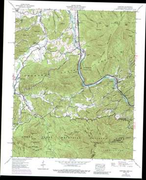
Hartford Topo Map Tennessee
To zoom in, hover over the map of Hartford
USGS Topo Quad 35083g2 - 1:24,000 scale
| Topo Map Name: | Hartford |
| USGS Topo Quad ID: | 35083g2 |
| Print Size: | ca. 21 1/4" wide x 27" high |
| Southeast Coordinates: | 35.75° N latitude / 83.125° W longitude |
| Map Center Coordinates: | 35.8125° N latitude / 83.1875° W longitude |
| U.S. States: | TN, NC |
| Filename: | o35083g2.jpg |
| Download Map JPG Image: | Hartford topo map 1:24,000 scale |
| Map Type: | Topographic |
| Topo Series: | 7.5´ |
| Map Scale: | 1:24,000 |
| Source of Map Images: | United States Geological Survey (USGS) |
| Alternate Map Versions: |
Hartford TN 1935 Download PDF Buy paper map Hartford TN 1940 Download PDF Buy paper map Hartford TN 1940, updated 1960 Download PDF Buy paper map Hartford TN 1940, updated 1965 Download PDF Buy paper map Hartford TN 1940, updated 1971 Download PDF Buy paper map Hartford TN 1940, updated 1975 Download PDF Buy paper map Hartford TN 1940, updated 1989 Download PDF Buy paper map Hartford TN 2003, updated 2004 Download PDF Buy paper map Hartford TN 2011 Download PDF Buy paper map Hartford TN 2013 Download PDF Buy paper map Hartford TN 2016 Download PDF Buy paper map |
| FStopo: | US Forest Service topo Hartford is available: Download FStopo PDF Download FStopo TIF |
1:24,000 Topo Quads surrounding Hartford
> Back to 35083e1 at 1:100,000 scale
> Back to 35082a1 at 1:250,000 scale
> Back to U.S. Topo Maps home
Hartford topo map: Gazetteer
Hartford: Crossings
Interchange 443 elevation 387m 1269′Interchange 447 elevation 382m 1253′
Hartford: Flats
Holly Flats elevation 524m 1719′Millstone Flats elevation 591m 1938′
Hartford: Gaps
Bear Neck Gap elevation 858m 2814′Hickorynut Gap elevation 755m 2477′
Toms Gap elevation 840m 2755′
Hartford: Islands
Brown Island elevation 355m 1164′Joe Green Island elevation 378m 1240′
Johnson Island elevation 383m 1256′
Naillon Island elevation 395m 1295′
Ryal Island elevation 346m 1135′
Smith Island elevation 376m 1233′
Wilson Island elevation 344m 1128′
Woods Island elevation 342m 1122′
Hartford: Populated Places
Allen Grove elevation 393m 1289′Bluffton elevation 373m 1223′
Catons Grove elevation 479m 1571′
Cosby elevation 409m 1341′
Denton elevation 356m 1167′
Finney Patch elevation 938m 3077′
Hartford elevation 382m 1253′
Jenkins Mill elevation 479m 1571′
Licklog elevation 690m 2263′
Naillontown (historical) elevation 400m 1312′
Padgett Mill elevation 374m 1227′
Hartford: Post Offices
Cosby Post Office elevation 466m 1528′Hartford Post Office elevation 387m 1269′
Hartford: Ridges
Cammerer Ridge elevation 943m 3093′Devils Backbone elevation 796m 2611′
Gilliland Ridge elevation 886m 2906′
Groundhog Ridge elevation 1075m 3526′
Leadmine Ridge elevation 965m 3166′
Rowdy Ridge elevation 941m 3087′
Sutton Ridge elevation 644m 2112′
Hartford: Springs
Gurgling Spring elevation 896m 2939′Proffit Spring elevation 414m 1358′
Hartford: Streams
Abe Branch elevation 456m 1496′Bailey Branch elevation 371m 1217′
Barnes Branch elevation 389m 1276′
Big Branch elevation 471m 1545′
Bogard Creek elevation 352m 1154′
Caney Creek elevation 434m 1423′
Carolina Prong elevation 590m 1935′
Chavis Creek elevation 389m 1276′
Cripple Creek elevation 378m 1240′
Crying Creek elevation 530m 1738′
Dry Branch elevation 374m 1227′
Fletcher Spring Branch elevation 510m 1673′
Gilliland Fork elevation 553m 1814′
Gray Branch elevation 370m 1213′
Greenbrier Creek elevation 425m 1394′
Groundhog Creek elevation 371m 1217′
Hen Wallow Creek elevation 507m 1663′
Huskycamp Branch elevation 375m 1230′
Indian Camp Creek elevation 426m 1397′
Lower Falling Branch elevation 664m 2178′
McFalls Branch elevation 518m 1699′
Messer Branch elevation 417m 1368′
Middle Creek elevation 362m 1187′
Mill Creek elevation 378m 1240′
Miller Branch elevation 373m 1223′
Naillon Branch elevation 397m 1302′
Panther Branch elevation 855m 2805′
Pigeonroost Branch elevation 390m 1279′
Polecat Branch elevation 361m 1184′
Polly Elbert Branch elevation 347m 1138′
Rabbit Branch elevation 370m 1213′
Richtop Branch elevation 377m 1236′
Riding Fork elevation 555m 1820′
Robinson Creek elevation 444m 1456′
Rock Creek elevation 624m 2047′
Rowdy Creek elevation 505m 1656′
Shoestring Branch elevation 391m 1282′
Stillhouse Branch elevation 481m 1578′
Tinker Branch elevation 398m 1305′
Toms Creek elevation 623m 2043′
Trail Hollow Branch elevation 385m 1263′
Turnalay Creek elevation 409m 1341′
Watertank Branch elevation 389m 1276′
Weaver Branch elevation 353m 1158′
Webb Branch elevation 454m 1489′
Hartford: Summits
Baker Knob elevation 849m 2785′Buzzard Roost elevation 795m 2608′
Chestnut Mountain elevation 834m 2736′
Denton Knob elevation 550m 1804′
Gabes Mountain elevation 958m 3143′
Green Mountain elevation 849m 2785′
Gulf Mountain elevation 639m 2096′
Hall Mountain elevation 1099m 3605′
Hall Top elevation 1099m 3605′
Harrison Knob elevation 548m 1797′
Kelly Knob elevation 553m 1814′
Mount Cammerer elevation 1423m 4668′
Mount Cammerer elevation 1499m 4917′
Padgett Knob elevation 510m 1673′
Panther Mountain elevation 837m 2746′
Potato Hill elevation 436m 1430′
Potter Knob elevation 532m 1745′
Raines Knob elevation 531m 1742′
Rich Butt Mountain elevation 1291m 4235′
Rich Top elevation 855m 2805′
Round Mountain elevation 930m 3051′
Stone Mountain elevation 1099m 3605′
Three Top Mountain elevation 920m 3018′
Turkey Knob elevation 1112m 3648′
Wildcat Knob elevation 649m 2129′
Hartford: Trails
Lower Whiterock Trail elevation 782m 2565′Messer Trail elevation 842m 2762′
Stone Mountain Trail elevation 623m 2043′
Hartford: Valleys
Bearneck Cove elevation 651m 2135′Cane Hollow elevation 378m 1240′
Cloverfield Hollow elevation 385m 1263′
Dark Hollow elevation 348m 1141′
Greasy Cove elevation 365m 1197′
Landin Cove elevation 360m 1181′
Laurel Hollow elevation 448m 1469′
Laurel Hollow elevation 376m 1233′
Moore Hollow elevation 426m 1397′
Possum Hollow elevation 461m 1512′
Trail Hollow elevation 388m 1272′
Zachy Hollow elevation 462m 1515′
Hartford digital topo map on disk
Buy this Hartford topo map showing relief, roads, GPS coordinates and other geographical features, as a high-resolution digital map file on DVD:
South Carolina, Western North Carolina & Northeastern Georgia
Buy digital topo maps: South Carolina, Western North Carolina & Northeastern Georgia


