Pigeon Forge Topo Map Tennessee
To zoom in, hover over the map of Pigeon Forge
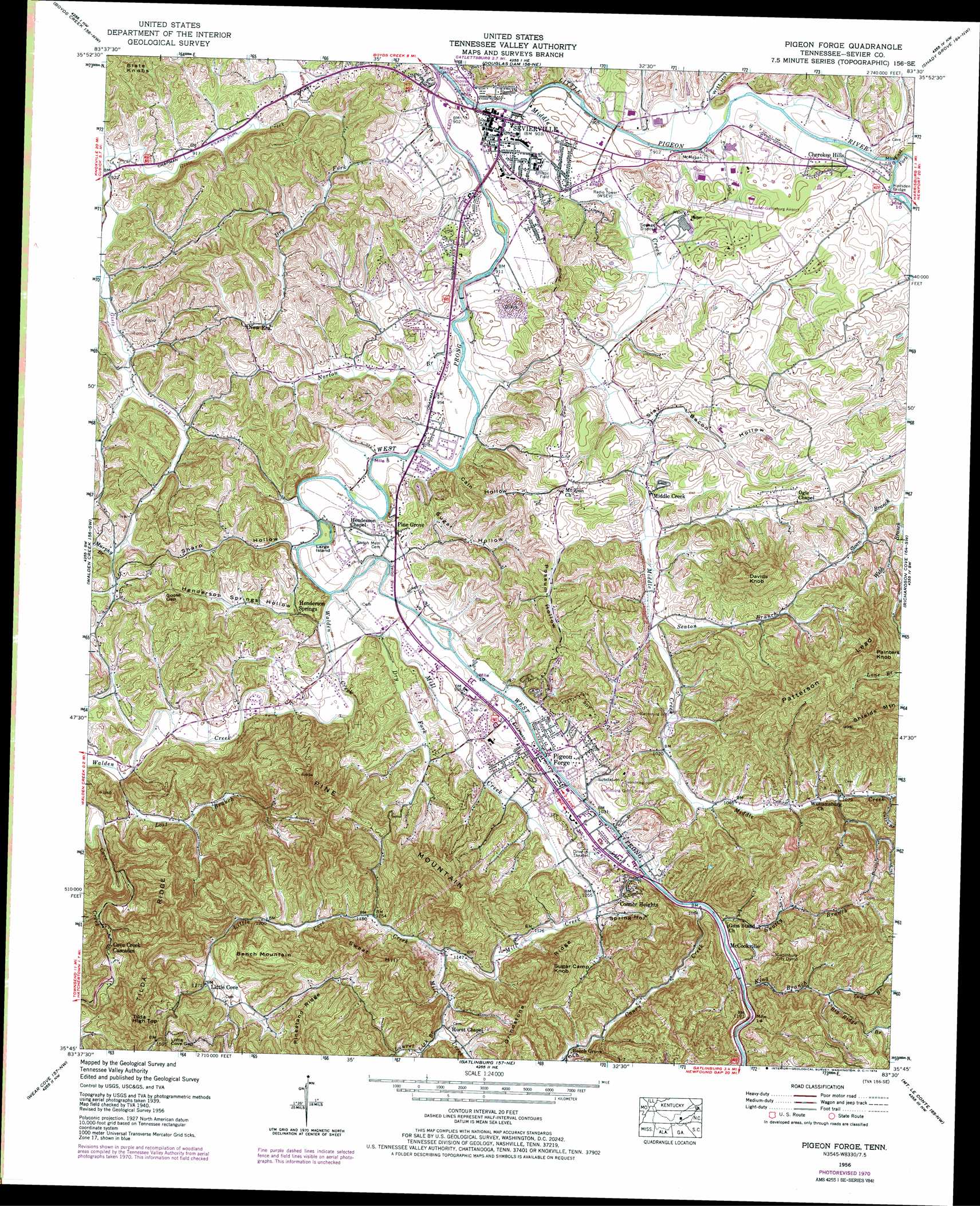
USGS Topo Quad 35083g5 - 1:24,000 scale
| Topo Map Name: | Pigeon Forge |
| USGS Topo Quad ID: | 35083g5 |
| Print Size: | ca. 21 1/4" wide x 27" high |
| Southeast Coordinates: | 35.75° N latitude / 83.5° W longitude |
| Map Center Coordinates: | 35.8125° N latitude / 83.5625° W longitude |
| U.S. State: | TN |
| Filename: | o35083g5.jpg |
| Download Map JPG Image: | Pigeon Forge topo map 1:24,000 scale |
| Map Type: | Topographic |
| Topo Series: | 7.5´ |
| Map Scale: | 1:24,000 |
| Source of Map Images: | United States Geological Survey (USGS) |
| Alternate Map Versions: |
Pigeon Forge TN 1935 Download PDF Buy paper map Pigeon Forge TN 1940 Download PDF Buy paper map Pigeon Forge TN 1956, updated 1958 Download PDF Buy paper map Pigeon Forge TN 1956, updated 1973 Download PDF Buy paper map Pigeon Forge TN 1956, updated 1973 Download PDF Buy paper map Pigeon Forge TN 2010 Download PDF Buy paper map Pigeon Forge TN 2013 Download PDF Buy paper map Pigeon Forge TN 2016 Download PDF Buy paper map |
1:24,000 Topo Quads surrounding Pigeon Forge
John Sevier |
Mascot |
New Market |
Jefferson City |
White Pine |
Shooks Gap |
Boyds Creek |
Douglas Dam |
Shady Grove |
Chestnut Hill |
Wildwood |
Walden Creek |
Pigeon Forge |
Richardson Cove |
Jones Cove |
Kinzel Springs |
Wear Cove |
Gatlinburg |
Mount Le Conte |
Mount Guyot |
Cades Cove |
Thunderhead Mountain |
Silers Bald |
Clingmans Dome |
Smokemont |
> Back to 35083e1 at 1:100,000 scale
> Back to 35082a1 at 1:250,000 scale
> Back to U.S. Topo Maps home
Pigeon Forge topo map: Gazetteer
Pigeon Forge: Airports
Sevier-Gatlinburg Airport elevation 304m 997′Pigeon Forge: Bridges
Hodsden Bridge elevation 283m 928′Pigeon Forge: Crossings
Birchfield Ford elevation 274m 898′Large Ford elevation 286m 938′
McClure Ford elevation 283m 928′
Pigeon Forge: Gaps
Goose Gap elevation 366m 1200′Little Cove Gap elevation 492m 1614′
Pigeon Forge: Islands
Large Island elevation 289m 948′Pigeon Forge: Populated Places
Cherokee Hills elevation 303m 994′Conner Heights elevation 349m 1145′
Cove Creek Cascades elevation 391m 1282′
Henderson Springs elevation 302m 990′
Little Cove elevation 387m 1269′
McCookville elevation 356m 1167′
Middle Creek elevation 300m 984′
Mount Zion elevation 340m 1115′
New Era elevation 304m 997′
Pigeon Forge elevation 305m 1000′
Pine Grove elevation 305m 1000′
Reagantown elevation 348m 1141′
Sevierville elevation 275m 902′
Williamsburg elevation 328m 1076′
Pigeon Forge: Post Offices
Pigeon Forge Post Office elevation 309m 1013′Sevierville Post Office elevation 276m 905′
Pigeon Forge: Ridges
Grindstone Ridge elevation 413m 1354′Patterson Lead elevation 489m 1604′
Pinestand Ridge elevation 511m 1676′
Tilda Ridge elevation 488m 1601′
Pigeon Forge: Streams
Big Ridge Branch elevation 374m 1227′Caney Creek elevation 320m 1049′
Caton Branch elevation 335m 1099′
Devils Branch elevation 366m 1200′
Dry Fork elevation 297m 974′
Dry Fork elevation 278m 912′
East Fork Little Pigeon River elevation 280m 918′
Gnatty Branch elevation 326m 1069′
King Branch elevation 331m 1085′
Laurel Lick Branch elevation 407m 1335′
Little Cove Creek elevation 340m 1115′
Lost Branch elevation 309m 1013′
Middle Creek elevation 274m 898′
Mill Creek elevation 292m 958′
Murphy Branch elevation 317m 1040′
Norton Branch elevation 276m 905′
Seaton Branch elevation 302m 990′
Todd Branch elevation 374m 1227′
Waldens Creek elevation 292m 958′
Webb Branch elevation 316m 1036′
West Fork Gists Creek elevation 279m 915′
West Prong Little Pigeon River elevation 268m 879′
Pigeon Forge: Summits
Bench Mountain elevation 499m 1637′Davids Knob elevation 498m 1633′
Painters Knob elevation 552m 1811′
Pine Mountain elevation 578m 1896′
Sugar Camp Knob elevation 492m 1614′
Sweat Hill elevation 522m 1712′
Tilda High Top elevation 584m 1916′
Pigeon Forge: Valleys
Cain Hollow elevation 286m 938′Gibson Hollow elevation 408m 1338′
Henderson Springs Hollow elevation 292m 958′
Mathis Hollow elevation 284m 931′
Possum Hollow elevation 320m 1049′
Sharp Hollow elevation 295m 967′
Slay Bacon Hollow elevation 292m 958′
Spring Hollow elevation 322m 1056′
Sugar Hollow elevation 283m 928′
Witt Hollow elevation 279m 915′
Pigeon Forge digital topo map on disk
Buy this Pigeon Forge topo map showing relief, roads, GPS coordinates and other geographical features, as a high-resolution digital map file on DVD:
South Carolina, Western North Carolina & Northeastern Georgia
Buy digital topo maps: South Carolina, Western North Carolina & Northeastern Georgia