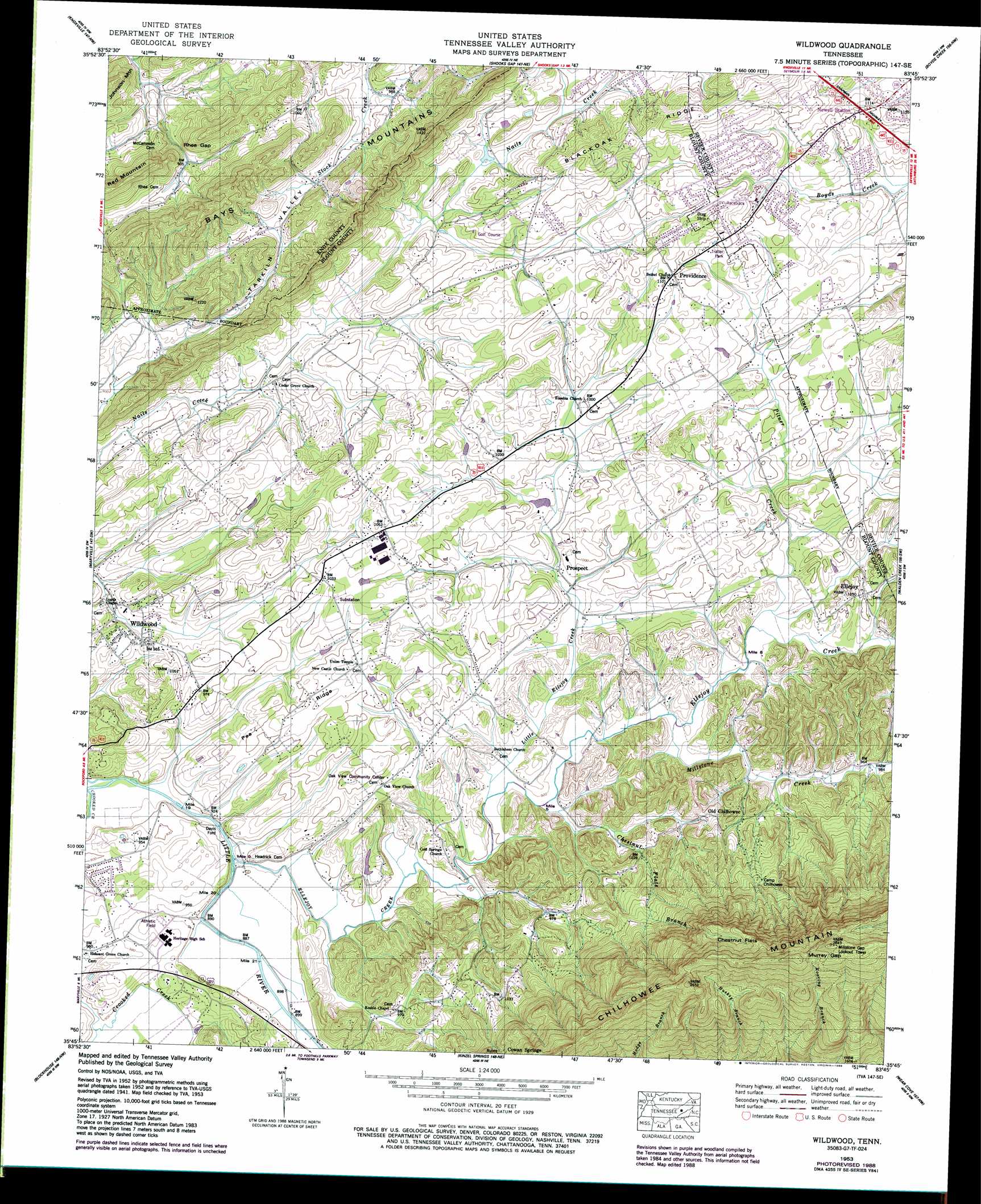
Wildwood Topo Map Tennessee
To zoom in, hover over the map of Wildwood
USGS Topo Quad 35083g7 - 1:24,000 scale
| Topo Map Name: | Wildwood |
| USGS Topo Quad ID: | 35083g7 |
| Print Size: | ca. 21 1/4" wide x 27" high |
| Southeast Coordinates: | 35.75° N latitude / 83.75° W longitude |
| Map Center Coordinates: | 35.8125° N latitude / 83.8125° W longitude |
| U.S. State: | TN |
| Filename: | o35083g7.jpg |
| Download Map JPG Image: | Wildwood topo map 1:24,000 scale |
| Map Type: | Topographic |
| Topo Series: | 7.5´ |
| Map Scale: | 1:24,000 |
| Source of Map Images: | United States Geological Survey (USGS) |
| Alternate Map Versions: |
Wildwood TN 1935 Download PDF Buy paper map Wildwood TN 1941 Download PDF Buy paper map Wildwood TN 1953, updated 1955 Download PDF Buy paper map Wildwood TN 1953, updated 1973 Download PDF Buy paper map Wildwood TN 1953, updated 1978 Download PDF Buy paper map Wildwood TN 1953, updated 1981 Download PDF Buy paper map Wildwood TN 1953, updated 1988 Download PDF Buy paper map Wildwood TN 2010 Download PDF Buy paper map Wildwood TN 2013 Download PDF Buy paper map Wildwood TN 2016 Download PDF Buy paper map |
1:24,000 Topo Quads surrounding Wildwood
Powell |
Fountain City |
John Sevier |
Mascot |
New Market |
Bearden |
Knoxville |
Shooks Gap |
Boyds Creek |
Douglas Dam |
Louisville |
Maryville |
Wildwood |
Walden Creek |
Pigeon Forge |
Binfield |
Blockhouse |
Kinzel Springs |
Wear Cove |
Gatlinburg |
Tallassee |
Calderwood |
Cades Cove |
Thunderhead Mountain |
Silers Bald |
> Back to 35083e1 at 1:100,000 scale
> Back to 35082a1 at 1:250,000 scale
> Back to U.S. Topo Maps home
Wildwood topo map: Gazetteer
Wildwood: Crossings
Davis Ford elevation 266m 872′Wildwood: Flats
Chestnut Flats elevation 650m 2132′Wildwood: Gaps
Murray Gap elevation 807m 2647′Rhea Gap elevation 284m 931′
Wildwood: Populated Places
Bays Mountain Estates elevation 324m 1062′Bayview elevation 313m 1026′
Cold Springs elevation 359m 1177′
Cowan Springs elevation 444m 1456′
Elajay (historical) elevation 283m 928′
Ellejoy elevation 307m 1007′
Fairfield elevation 299m 980′
Huskey Valley elevation 314m 1030′
Newell Station elevation 337m 1105′
Oak View elevation 292m 958′
Old Chilhowee elevation 293m 961′
Prospect elevation 288m 944′
Providence elevation 334m 1095′
Wildwood elevation 278m 912′
Wildwood: Ridges
Blackoak Ridge elevation 347m 1138′Chilhowee Mountain elevation 863m 2831′
Pea Ridge elevation 309m 1013′
Wildwood: Streams
Chestnut Flats Branch elevation 276m 905′Crooked Creek elevation 271m 889′
Ellejoy Creek elevation 266m 872′
Little Ellejoy Creek elevation 276m 905′
Millstone Creek elevation 278m 912′
Pitner Creek elevation 281m 921′
Rocky Branch elevation 271m 889′
Wildwood: Summits
Red Mountain elevation 403m 1322′Yankee Hill elevation 343m 1125′
Wildwood: Valleys
Ellejoy Valley elevation 270m 885′Tipton Hollow elevation 296m 971′
Wildwood digital topo map on disk
Buy this Wildwood topo map showing relief, roads, GPS coordinates and other geographical features, as a high-resolution digital map file on DVD:
South Carolina, Western North Carolina & Northeastern Georgia
Buy digital topo maps: South Carolina, Western North Carolina & Northeastern Georgia