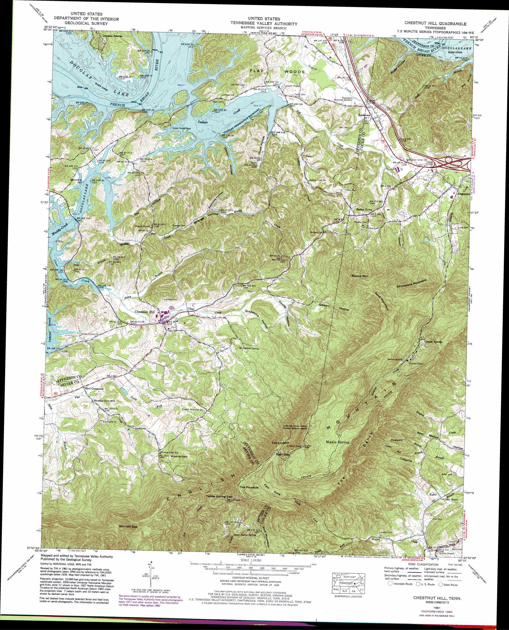
Chestnut Hill Topo Map Tennessee
To zoom in, hover over the map of Chestnut Hill
USGS Topo Quad 35083h3 - 1:24,000 scale
| Topo Map Name: | Chestnut Hill |
| USGS Topo Quad ID: | 35083h3 |
| Print Size: | ca. 21 1/4" wide x 27" high |
| Southeast Coordinates: | 35.875° N latitude / 83.25° W longitude |
| Map Center Coordinates: | 35.9375° N latitude / 83.3125° W longitude |
| U.S. State: | TN |
| Filename: | o35083h3.jpg |
| Download Map JPG Image: | Chestnut Hill topo map 1:24,000 scale |
| Map Type: | Topographic |
| Topo Series: | 7.5´ |
| Map Scale: | 1:24,000 |
| Source of Map Images: | United States Geological Survey (USGS) |
| Alternate Map Versions: |
Clevenger TN 1935 Download PDF Buy paper map Clevenger TN 1939, updated 1954 Download PDF Buy paper map Clevenger TN 1940 Download PDF Buy paper map Chestnut Hill TN 1961, updated 1964 Download PDF Buy paper map Chestnut Hill TN 1961, updated 1980 Download PDF Buy paper map Chestnut Hill TN 1961, updated 1980 Download PDF Buy paper map Chestnut Hill TN 2010 Download PDF Buy paper map Chestnut Hill TN 2013 Download PDF Buy paper map Chestnut Hill TN 2016 Download PDF Buy paper map |
1:24,000 Topo Quads surrounding Chestnut Hill
Joppa |
Talbott |
Morristown |
Springvale |
Mohawk |
New Market |
Jefferson City |
White Pine |
Rankin |
Parrotsville |
Douglas Dam |
Shady Grove |
Chestnut Hill |
Newport |
Neddy Mountain |
Pigeon Forge |
Richardson Cove |
Jones Cove |
Hartford |
Waterville |
Gatlinburg |
Mount Le Conte |
Mount Guyot |
Luftee Knob |
Cove Creek Gap |
> Back to 35083e1 at 1:100,000 scale
> Back to 35082a1 at 1:250,000 scale
> Back to U.S. Topo Maps home
Chestnut Hill topo map: Gazetteer
Chestnut Hill: Bars
Elliots Shoals elevation 305m 1000′Chestnut Hill: Benches
The Bench elevation 823m 2700′Chestnut Hill: Crossings
Elliot Ferry (historical) elevation 305m 1000′Interchange 432 elevation 381m 1250′
Chestnut Hill: Gaps
Split Gap elevation 1094m 3589′Stinnett Gap elevation 708m 2322′
Yellow Spring Gap elevation 745m 2444′
Chestnut Hill: Populated Places
Bailey Town elevation 405m 1328′Bird Crossroad elevation 349m 1145′
Carson Springs elevation 576m 1889′
Chestnut Hill elevation 327m 1072′
Clevenger elevation 398m 1305′
Douglas Estates elevation 338m 1108′
Edgemont elevation 399m 1309′
Maple Spring elevation 979m 3211′
Promised Land elevation 372m 1220′
Reidtown elevation 356m 1167′
Tryon elevation 316m 1036′
Chestnut Hill: Springs
Glenn Alpine Spring elevation 682m 2237′McAndrew Spring elevation 411m 1348′
Chestnut Hill: Streams
Ball Creek elevation 305m 1000′Bear Branch elevation 306m 1003′
Betsy Branch elevation 335m 1099′
Camp Bell Branch elevation 442m 1450′
Clear Creek elevation 305m 1000′
Hall Branch elevation 305m 1000′
Huff Branch elevation 305m 1000′
Indian Creek elevation 305m 1000′
Jones Branch elevation 350m 1148′
Moore Branch elevation 305m 1000′
Muddy Hollow Branch elevation 305m 1000′
North Fork Bogard Creek elevation 470m 1541′
Slatey Branch elevation 310m 1017′
South Fork Bogard Creek elevation 470m 1541′
Turkeypen Branch elevation 434m 1423′
Chestnut Hill: Summits
English Mountain elevation 1106m 3628′Grindstone Mountain elevation 757m 2483′
Round Mountain elevation 810m 2657′
Sand Mountain elevation 829m 2719′
The Lookoff elevation 1012m 3320′
The Pinnacle elevation 1025m 3362′
Chestnut Hill: Valleys
Denton Hollow elevation 305m 1000′Dooley Hollow elevation 371m 1217′
Fain Cove elevation 849m 2785′
Gibson Hollow elevation 404m 1325′
Grapevine Hollow elevation 371m 1217′
Gunter Hollow elevation 314m 1030′
Pruitt Hollow elevation 305m 1000′
Ray Hollow elevation 305m 1000′
Reynolds Hollow elevation 326m 1069′
Shropshire Hollow elevation 309m 1013′
Still House Hollow elevation 305m 1000′
Strange Hollow elevation 310m 1017′
Sugar Hollow elevation 305m 1000′
Chestnut Hill digital topo map on disk
Buy this Chestnut Hill topo map showing relief, roads, GPS coordinates and other geographical features, as a high-resolution digital map file on DVD:
South Carolina, Western North Carolina & Northeastern Georgia
Buy digital topo maps: South Carolina, Western North Carolina & Northeastern Georgia