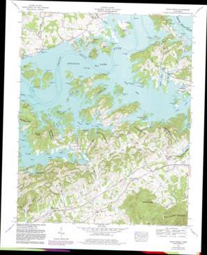
Shady Grove Topo Map Tennessee
To zoom in, hover over the map of Shady Grove
USGS Topo Quad 35083h4 - 1:24,000 scale
| Topo Map Name: | Shady Grove |
| USGS Topo Quad ID: | 35083h4 |
| Print Size: | ca. 21 1/4" wide x 27" high |
| Southeast Coordinates: | 35.875° N latitude / 83.375° W longitude |
| Map Center Coordinates: | 35.9375° N latitude / 83.4375° W longitude |
| U.S. State: | TN |
| Filename: | o35083h4.jpg |
| Download Map JPG Image: | Shady Grove topo map 1:24,000 scale |
| Map Type: | Topographic |
| Topo Series: | 7.5´ |
| Map Scale: | 1:24,000 |
| Source of Map Images: | United States Geological Survey (USGS) |
| Alternate Map Versions: |
Shady Grove TN 1935 Download PDF Buy paper map Shady Grove TN 1939 Download PDF Buy paper map Shady Grove TN 1939, updated 1954 Download PDF Buy paper map Shady Grove TN 1961, updated 1963 Download PDF Buy paper map Shady Grove TN 1961, updated 1980 Download PDF Buy paper map Shady Grove TN 2010 Download PDF Buy paper map Shady Grove TN 2013 Download PDF Buy paper map Shady Grove TN 2016 Download PDF Buy paper map |
1:24,000 Topo Quads surrounding Shady Grove
> Back to 35083e1 at 1:100,000 scale
> Back to 35082a1 at 1:250,000 scale
> Back to U.S. Topo Maps home
Shady Grove topo map: Gazetteer
Shady Grove: Bars
Alley Ford Shoals elevation 305m 1000′Cawoods Shoal elevation 305m 1000′
Dentons Shoals elevation 305m 1000′
Fains Shoals elevation 305m 1000′
Harrison Shoals elevation 305m 1000′
Nichols Reef elevation 305m 1000′
Swanns Island Shoals elevation 305m 1000′
Shady Grove: Basins
The Sink elevation 509m 1669′Shady Grove: Crossings
Alley Ford (historical) elevation 305m 1000′Shady Grove: Islands
Bird Island (historical) elevation 305m 1000′Ernest Fox Island (historical) elevation 305m 1000′
Fox Island (historical) elevation 305m 1000′
Harrison Islands (historical) elevation 305m 1000′
Henderson Island elevation 310m 1017′
Hunter Island (historical) elevation 305m 1000′
McMann Island (historical) elevation 305m 1000′
Swann Island (historical) elevation 305m 1000′
Shady Grove: Parks
Henderson Island Wildlife Refuge elevation 312m 1023′Shady Grove: Populated Places
Allensville (historical) elevation 305m 1000′Fox (historical) elevation 347m 1138′
Pleasant Hill (historical) elevation 305m 1000′
Sandy Ridge elevation 310m 1017′
Schroder (historical) elevation 342m 1122′
Shady Grove elevation 308m 1010′
Walnut Grove elevation 316m 1036′
Shady Grove: Springs
Roaring Spring elevation 308m 1010′Shady Grove: Streams
Anderson Branch elevation 305m 1000′Big Branch elevation 305m 1000′
Chambers Branch elevation 305m 1000′
Frye Branch elevation 305m 1000′
Goose Creek elevation 306m 1003′
Hettie Creek elevation 307m 1007′
Holbert Branch (historical) elevation 305m 1000′
Leeper Branch (historical) elevation 305m 1000′
Manning Branch (historical) elevation 305m 1000′
McCracken Branch elevation 305m 1000′
McGuire Creek elevation 305m 1000′
Miller Creek elevation 305m 1000′
Muddy Creek elevation 305m 1000′
Patterson Branch elevation 307m 1007′
Patterson Branch elevation 314m 1030′
Patterson Branch elevation 305m 1000′
Perry Branch elevation 305m 1000′
Rollins Branch elevation 305m 1000′
Sandy Ridge Branch elevation 305m 1000′
Shadden Creek elevation 305m 1000′
Silva Branch elevation 305m 1000′
Slatey Creek (historical) elevation 305m 1000′
Walnut Grove Branch elevation 304m 997′
Wells Branch elevation 307m 1007′
Shady Grove: Summits
Little Mountain elevation 614m 2014′Old Egypt elevation 359m 1177′
Red Oak Knobs elevation 367m 1204′
Tater Knob elevation 346m 1135′
Shady Grove: Valleys
Boat Gunnel Hollow elevation 307m 1007′Finchum Hollow elevation 305m 1000′
Happy Hollow elevation 305m 1000′
Long Hollow elevation 299m 980′
Muddy Hollow elevation 305m 1000′
Patterson Hollow elevation 311m 1020′
Sugar Camp Hollow elevation 328m 1076′
Shady Grove digital topo map on disk
Buy this Shady Grove topo map showing relief, roads, GPS coordinates and other geographical features, as a high-resolution digital map file on DVD:
South Carolina, Western North Carolina & Northeastern Georgia
Buy digital topo maps: South Carolina, Western North Carolina & Northeastern Georgia


