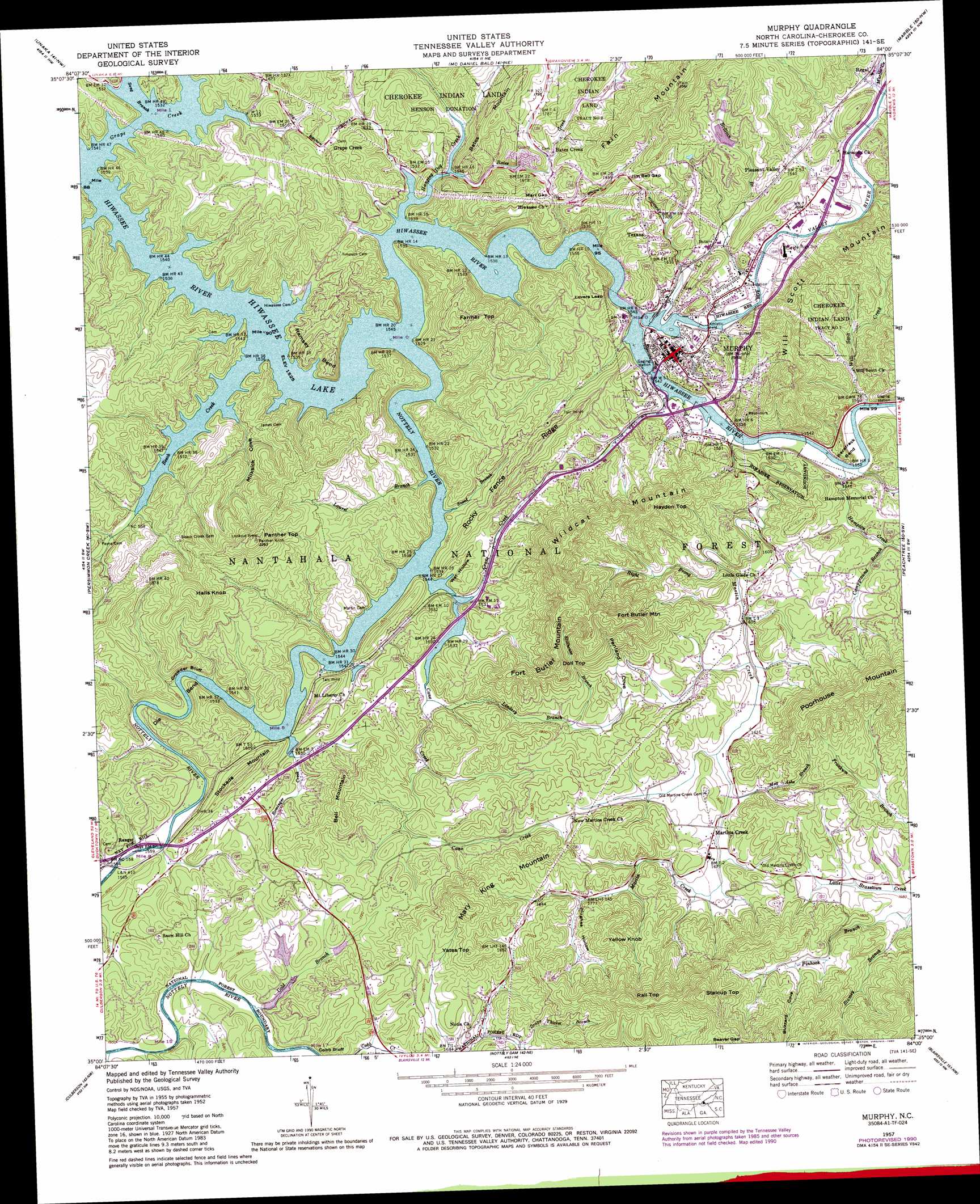
Murphy Topo Map North Carolina
To zoom in, hover over the map of Murphy
USGS Topo Quad 35084a1 - 1:24,000 scale
| Topo Map Name: | Murphy |
| USGS Topo Quad ID: | 35084a1 |
| Print Size: | ca. 21 1/4" wide x 27" high |
| Southeast Coordinates: | 35° N latitude / 84° W longitude |
| Map Center Coordinates: | 35.0625° N latitude / 84.0625° W longitude |
| U.S. State: | NC |
| Filename: | o35084a1.jpg |
| Download Map JPG Image: | Murphy topo map 1:24,000 scale |
| Map Type: | Topographic |
| Topo Series: | 7.5´ |
| Map Scale: | 1:24,000 |
| Source of Map Images: | United States Geological Survey (USGS) |
| Alternate Map Versions: |
Murphy NC 1934 Download PDF Buy paper map Murphy NC 1957, updated 1958 Download PDF Buy paper map Murphy NC 1957, updated 1963 Download PDF Buy paper map Murphy NC 1957, updated 1975 Download PDF Buy paper map Murphy NC 1957, updated 1990 Download PDF Buy paper map Murphy NC 2011 Download PDF Buy paper map Murphy NC 2013 Download PDF Buy paper map Murphy NC 2016 Download PDF Buy paper map |
| FStopo: | US Forest Service topo Murphy is available: Download FStopo PDF Download FStopo TIF |
1:24,000 Topo Quads surrounding Murphy
Tellico Plains |
Bald River Falls |
Big Junction |
Santeetlah Creek |
Robbinsville |
Farner |
Unaka |
Mcdaniel Bald |
Marble |
Andrews |
Isabella |
Persimmon Creek |
Murphy |
Peachtree |
Hayesville |
Mineral Bluff |
Culberson |
Nottely Dam |
Blairsville |
Hiawassee |
Blue Ridge |
Wilscot |
Mulky Gap |
Coosa Bald |
Jacks Gap |
> Back to 35084a1 at 1:100,000 scale
> Back to 35084a1 at 1:250,000 scale
> Back to U.S. Topo Maps home
Murphy topo map: Gazetteer
Murphy: Airports
Tusquitee Airport elevation 491m 1610′Murphy: Bends
Die Bend elevation 502m 1646′Racetrack Bend elevation 498m 1633′
Ramsey Bend elevation 517m 1696′
Murphy: Cliffs
Cobb Bluff elevation 483m 1584′Crowder Bluff elevation 486m 1594′
Lovers Leap elevation 535m 1755′
Murphy: Dams
Brewer Lake Dam elevation 494m 1620′Harold Wells Dam elevation 486m 1594′
Tanglewood Dam Number Two elevation 584m 1916′
Tanglewood Dam Upper elevation 558m 1830′
Whitmire Dam Lower elevation 520m 1706′
Whitmire Dam Upper elevation 538m 1765′
Murphy: Gaps
Beaver Gap elevation 732m 2401′Jim Bell Gap elevation 590m 1935′
Marr Gap elevation 539m 1768′
Murphy: Populated Places
Bates Creek elevation 537m 1761′Grape Creek elevation 522m 1712′
Martins Creek elevation 507m 1663′
Murphy elevation 486m 1594′
Pleasant Valley elevation 501m 1643′
Regal elevation 483m 1584′
Texana elevation 534m 1751′
Murphy: Reservoirs
Brewer Lake elevation 494m 1620′Harold Wells Lake elevation 486m 1594′
Tanglewood Lake Number Two elevation 584m 1916′
Tanglewood Lake Upper elevation 558m 1830′
Whitmire Lake Lower elevation 520m 1706′
Whitmire Lake Upper elevation 538m 1765′
Murphy: Ridges
Rocky Fence Ridge elevation 569m 1866′Murphy: Streams
Bates Creek elevation 465m 1525′Beech Creek elevation 459m 1505′
Brittian Branch elevation 467m 1532′
Campground Branch elevation 485m 1591′
Cane Creek elevation 459m 1505′
Crane Creek elevation 464m 1522′
Gold Branch elevation 480m 1574′
Grape Creek elevation 459m 1505′
Grape Thicket Branch elevation 517m 1696′
Hampton Creek elevation 467m 1532′
Hanging Dog Creek elevation 459m 1505′
Laurel Branch elevation 466m 1528′
Lindsey Branch elevation 467m 1532′
Mag Ashe Branch elevation 499m 1637′
Marble Creek elevation 475m 1558′
Martin Creek elevation 465m 1525′
Nottely River elevation 458m 1502′
Palmer Branch elevation 466m 1528′
Right Prong Martin Creek elevation 486m 1594′
Rominger Creek elevation 466m 1528′
Sneed Branch elevation 459m 1505′
Song Branch elevation 459m 1505′
Stillhouse Branch elevation 504m 1653′
Valley River elevation 461m 1512′
Walker Mill Creek elevation 473m 1551′
Will Scott Creek elevation 469m 1538′
Murphy: Summits
Bates Mountain elevation 624m 2047′Bell Mountain elevation 616m 2020′
Doll Top elevation 667m 2188′
Fains Knob elevation 776m 2545′
Farmer Top elevation 631m 2070′
Fort Butler Mountain elevation 669m 2194′
Halls Knob elevation 684m 2244′
Haydon Top elevation 670m 2198′
Mary King Mountain elevation 699m 2293′
Panther Top elevation 697m 2286′
Poorhouse Mountain elevation 778m 2552′
Rall Top elevation 758m 2486′
Shingle Top elevation 705m 2312′
Stalcup Top elevation 800m 2624′
Stockade Mountain elevation 565m 1853′
Wildcat Mountain elevation 658m 2158′
Yates Top elevation 661m 2168′
Yellow Knob elevation 670m 2198′
Murphy: Valleys
Buzzard Cove elevation 583m 1912′Hughes Hollow elevation 539m 1768′
Milksick Cove elevation 475m 1558′
Penland Cove elevation 501m 1643′
Wet Hollow elevation 459m 1505′
Murphy digital topo map on disk
Buy this Murphy topo map showing relief, roads, GPS coordinates and other geographical features, as a high-resolution digital map file on DVD: