Persimmon Creek Topo Map North Carolina
To zoom in, hover over the map of Persimmon Creek
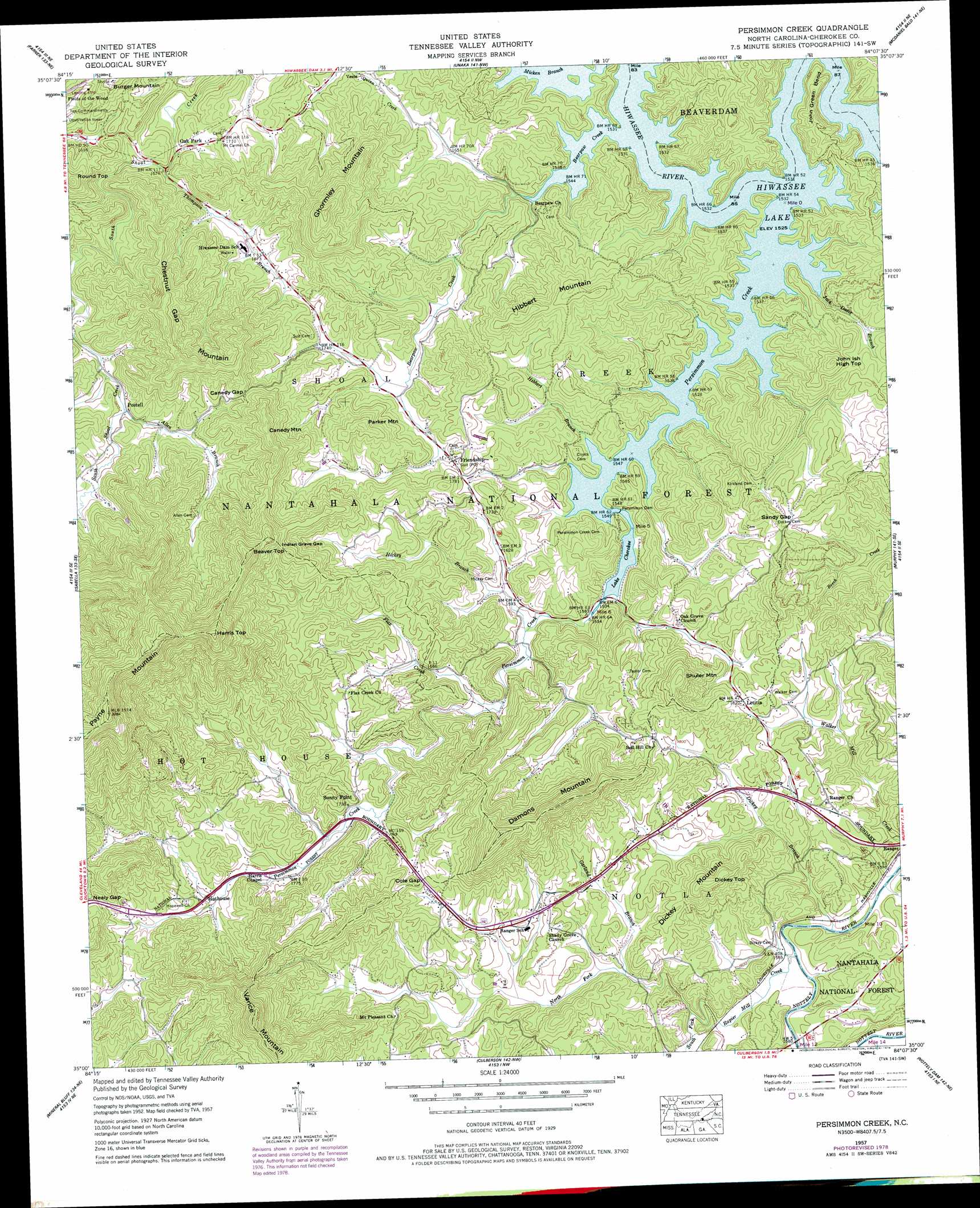
USGS Topo Quad 35084a2 - 1:24,000 scale
| Topo Map Name: | Persimmon Creek |
| USGS Topo Quad ID: | 35084a2 |
| Print Size: | ca. 21 1/4" wide x 27" high |
| Southeast Coordinates: | 35° N latitude / 84.125° W longitude |
| Map Center Coordinates: | 35.0625° N latitude / 84.1875° W longitude |
| U.S. State: | NC |
| Filename: | o35084a2.jpg |
| Download Map JPG Image: | Persimmon Creek topo map 1:24,000 scale |
| Map Type: | Topographic |
| Topo Series: | 7.5´ |
| Map Scale: | 1:24,000 |
| Source of Map Images: | United States Geological Survey (USGS) |
| Alternate Map Versions: |
Persimmon Creek NC 1934 Download PDF Buy paper map Persimmon Creek NC 1957, updated 1958 Download PDF Buy paper map Persimmon Creek NC 1957, updated 1968 Download PDF Buy paper map Persimmon Creek NC 1957, updated 1978 Download PDF Buy paper map Persimmon Creek NC 2011 Download PDF Buy paper map Persimmon Creek NC 2013 Download PDF Buy paper map Persimmon Creek NC 2016 Download PDF Buy paper map |
| FStopo: | US Forest Service topo Persimmon Creek is available: Download FStopo PDF Download FStopo TIF |
1:24,000 Topo Quads surrounding Persimmon Creek
Mecca |
Tellico Plains |
Bald River Falls |
Big Junction |
Santeetlah Creek |
Mcfarland |
Farner |
Unaka |
Mcdaniel Bald |
Marble |
Ducktown |
Isabella |
Persimmon Creek |
Murphy |
Peachtree |
Epworth |
Mineral Bluff |
Culberson |
Nottely Dam |
Blairsville |
Cashes Valley |
Blue Ridge |
Wilscot |
Mulky Gap |
Coosa Bald |
> Back to 35084a1 at 1:100,000 scale
> Back to 35084a1 at 1:250,000 scale
> Back to U.S. Topo Maps home
Persimmon Creek topo map: Gazetteer
Persimmon Creek: Bends
John Green Bend elevation 526m 1725′Persimmon Creek: Dams
Hideaway Mountain Lake Dam elevation 609m 1998′Persimmon Dam elevation 474m 1555′
Persimmon Dam elevation 470m 1541′
Pied Piper Dam Lower elevation 553m 1814′
Pied Piper Dam Upper elevation 560m 1837′
Sandy Gap Dam Number One elevation 552m 1811′
Sandy Gap Dam Number Two elevation 533m 1748′
Persimmon Creek: Gaps
Canedy Gap elevation 619m 2030′Cole Gap elevation 581m 1906′
Indian Grave Gap elevation 706m 2316′
Nealy Gap elevation 623m 2043′
Sandy Gap elevation 558m 1830′
Persimmon Creek: Parks
Ten Commandments elevation 543m 1781′Persimmon Creek: Populated Places
Friendship elevation 534m 1751′Hothouse elevation 561m 1840′
Letitia elevation 556m 1824′
Oak Park elevation 484m 1587′
Postell elevation 545m 1788′
Sunny Point elevation 546m 1791′
Vests elevation 512m 1679′
Persimmon Creek: Reservoirs
Hideaway Mountain Lake elevation 609m 1998′Lake Cherokee elevation 474m 1555′
Persimmon Lake elevation 470m 1541′
Pied Piper Lake Lower elevation 553m 1814′
Pied Piper Lake Upper elevation 560m 1837′
Sandy Gap Lake Number One elevation 552m 1811′
Sandy Gap Lake Number Two elevation 533m 1748′
Persimmon Creek: Streams
Allen Branch elevation 542m 1778′Bearpen Creek elevation 459m 1505′
Dickey Branch elevation 474m 1555′
Flax Creek elevation 483m 1584′
Garland Branch elevation 507m 1663′
Hibbert Branch elevation 459m 1505′
Hickey Branch elevation 472m 1548′
Jack Davis Branch elevation 481m 1578′
North Fork Rapier Mill Creek elevation 484m 1587′
Persimmon Creek elevation 458m 1502′
Rapier Mill Creek elevation 475m 1558′
South Fork Rapier Mill Creek elevation 484m 1587′
South Fork Rapier Mill Creek elevation 485m 1591′
Thompson Branch elevation 481m 1578′
Persimmon Creek: Summits
Beaver Top elevation 705m 2312′Burger Mountain elevation 629m 2063′
Canedy Mountain elevation 723m 2372′
Chestnut Gap Mountain elevation 726m 2381′
Damons Mountain elevation 767m 2516′
Dickey Mountain elevation 645m 2116′
Dickey Top elevation 648m 2125′
Ghormley Mountain elevation 739m 2424′
Harris Top elevation 913m 2995′
Hibbert Mountain elevation 629m 2063′
John Ish High Top elevation 596m 1955′
Parker Mountain elevation 640m 2099′
Payne Mountain elevation 999m 3277′
Round Top elevation 646m 2119′
Shuler Mountain elevation 670m 2198′
Vance Mountain elevation 822m 2696′
Persimmon Creek digital topo map on disk
Buy this Persimmon Creek topo map showing relief, roads, GPS coordinates and other geographical features, as a high-resolution digital map file on DVD: