Riceville Topo Map Tennessee
To zoom in, hover over the map of Riceville
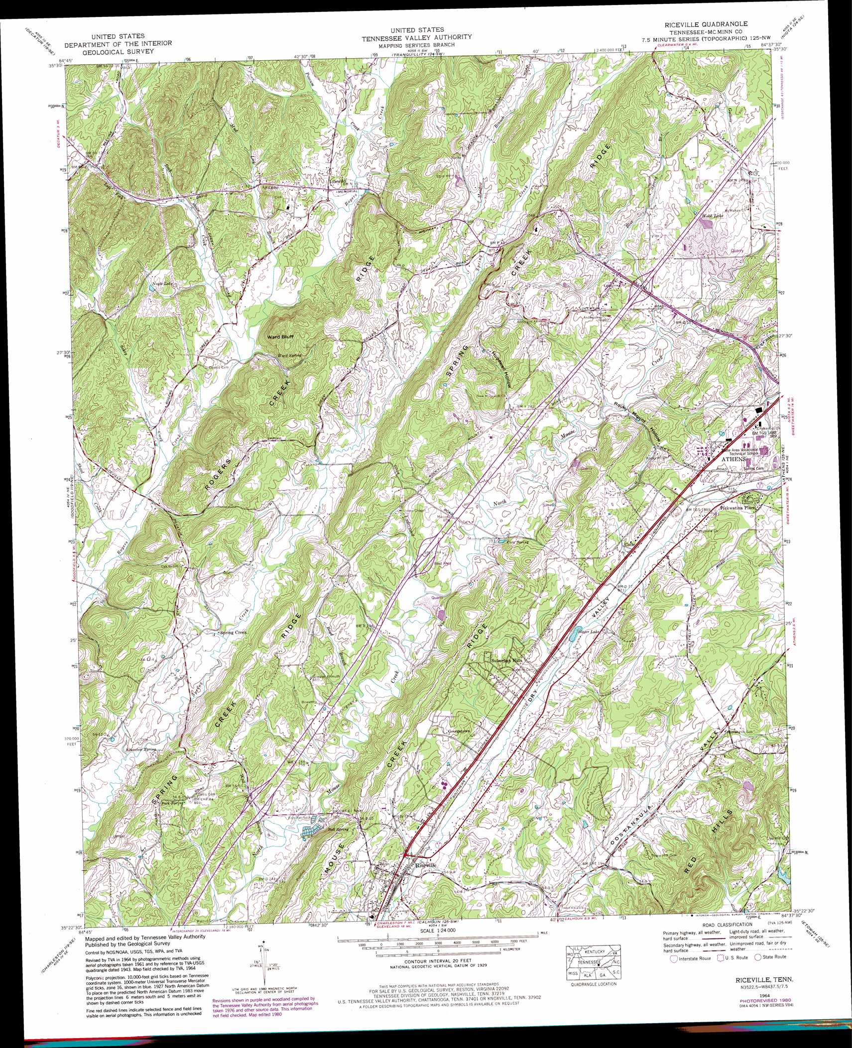
USGS Topo Quad 35084d6 - 1:24,000 scale
| Topo Map Name: | Riceville |
| USGS Topo Quad ID: | 35084d6 |
| Print Size: | ca. 21 1/4" wide x 27" high |
| Southeast Coordinates: | 35.375° N latitude / 84.625° W longitude |
| Map Center Coordinates: | 35.4375° N latitude / 84.6875° W longitude |
| U.S. State: | TN |
| Filename: | o35084d6.jpg |
| Download Map JPG Image: | Riceville topo map 1:24,000 scale |
| Map Type: | Topographic |
| Topo Series: | 7.5´ |
| Map Scale: | 1:24,000 |
| Source of Map Images: | United States Geological Survey (USGS) |
| Alternate Map Versions: |
Riceville TN 1935 Download PDF Buy paper map Riceville TN 1943, updated 1946 Download PDF Buy paper map Riceville TN 1943, updated 1960 Download PDF Buy paper map Riceville TN 1964, updated 1966 Download PDF Buy paper map Riceville TN 1964, updated 1980 Download PDF Buy paper map Riceville TN 1964, updated 1996 Download PDF Buy paper map Riceville TN 2010 Download PDF Buy paper map Riceville TN 2013 Download PDF Buy paper map Riceville TN 2016 Download PDF Buy paper map |
1:24,000 Topo Quads surrounding Riceville
Pennine |
Spring City |
Ten Mile |
Pattie Gap |
Philadelphia |
Evensville |
Decatur |
Tranquillity |
Niota |
Sweetwater |
Big Spring |
Goodfield |
Riceville |
Athens |
Englewood |
Birchwood |
Charleston |
Calhoun |
Etowah |
Mecca |
South Cleveland |
East Cleveland |
Benton |
Oswald Dome |
Mcfarland |
> Back to 35084a1 at 1:100,000 scale
> Back to 35084a1 at 1:250,000 scale
> Back to U.S. Topo Maps home
Riceville topo map: Gazetteer
Riceville: Cliffs
Ward Bluff elevation 287m 941′Riceville: Crossings
Interchange 42 elevation 229m 751′Interchange 49 elevation 245m 803′
Riceville: Dams
William Browder Dam elevation 280m 918′Riceville: Populated Places
Coile elevation 276m 905′Georgetown elevation 271m 889′
Idlewild elevation 237m 777′
Pickwatina Place elevation 294m 964′
Poplar Hill elevation 273m 895′
Riceville elevation 255m 836′
Spring Creek elevation 247m 810′
Suburban Hills elevation 281m 921′
Riceville: Post Offices
Riceville Post Office elevation 253m 830′Riceville: Reservoirs
Blazer Lake elevation 259m 849′Nagle Lake elevation 251m 823′
Webb Lake elevation 256m 839′
William Browder Lake elevation 280m 918′
Riceville: Ridges
Rogers Creek Ridge elevation 293m 961′Spring Creek Ridge elevation 333m 1092′
Riceville: Springs
Bell Spring elevation 224m 734′Cate Spring elevation 236m 774′
Kinzalow Spring elevation 243m 797′
Peck Spring elevation 248m 813′
Ward Spring elevation 231m 757′
Riceville: Streams
Blue Spring Branch elevation 241m 790′Boyd Branch elevation 230m 754′
Hopewell Branch elevation 237m 777′
Left Fork Rock Creek elevation 238m 780′
Meadow Branch elevation 263m 862′
Mud Lick Branch elevation 230m 754′
Possum Creek elevation 237m 777′
Rock Creek elevation 226m 741′
Shoal Creek elevation 224m 734′
Sokey Creek elevation 224m 734′
Underwood Branch elevation 230m 754′
Wall Hollow Branch elevation 223m 731′
Riceville: Summits
Red Hills elevation 312m 1023′Riceville: Valleys
Hopewell Hollow elevation 243m 797′Rocky Mount Hollow elevation 237m 777′
Riceville digital topo map on disk
Buy this Riceville topo map showing relief, roads, GPS coordinates and other geographical features, as a high-resolution digital map file on DVD: