Goodfield Topo Map Tennessee
To zoom in, hover over the map of Goodfield
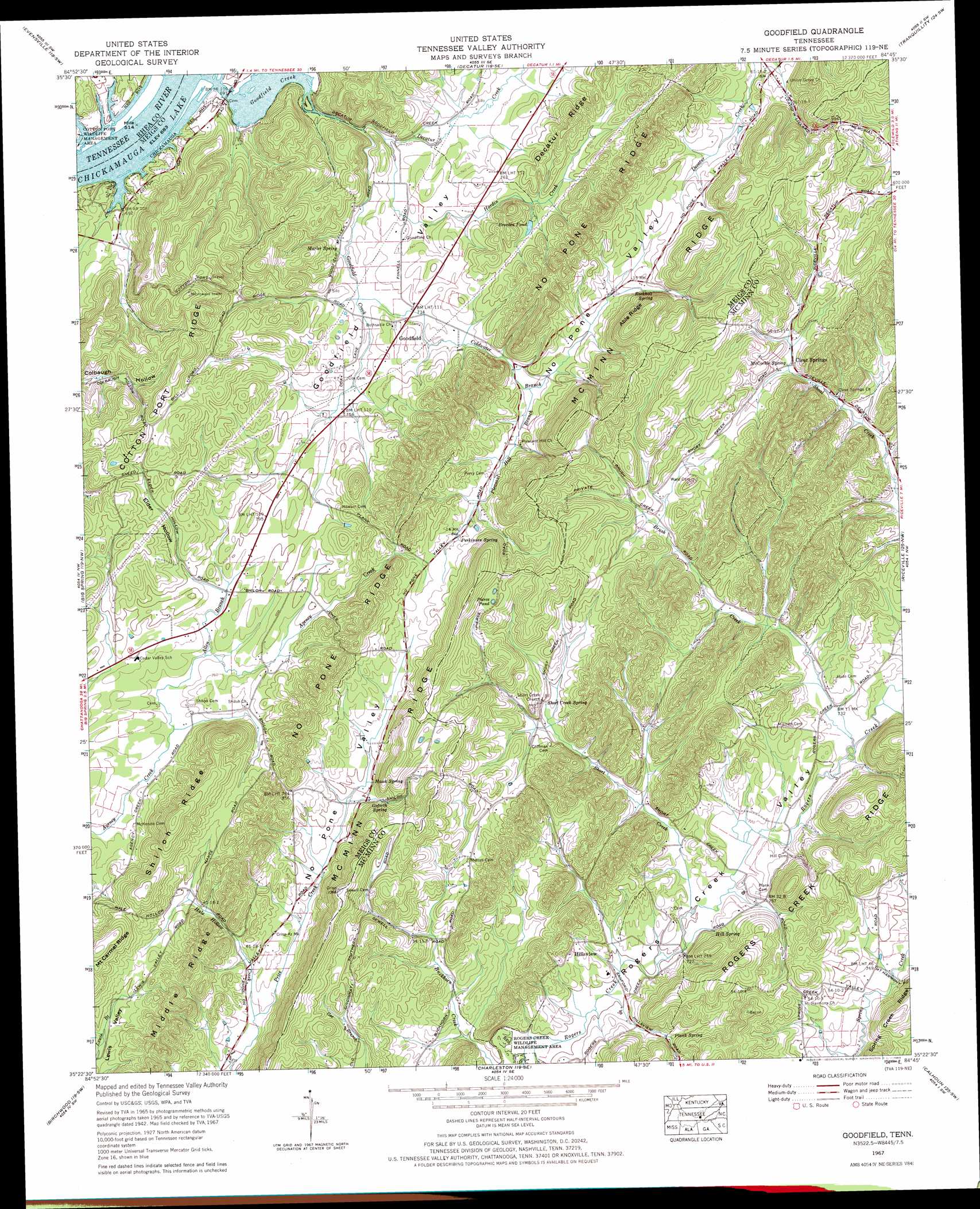
USGS Topo Quad 35084d7 - 1:24,000 scale
| Topo Map Name: | Goodfield |
| USGS Topo Quad ID: | 35084d7 |
| Print Size: | ca. 21 1/4" wide x 27" high |
| Southeast Coordinates: | 35.375° N latitude / 84.75° W longitude |
| Map Center Coordinates: | 35.4375° N latitude / 84.8125° W longitude |
| U.S. State: | TN |
| Filename: | o35084d7.jpg |
| Download Map JPG Image: | Goodfield topo map 1:24,000 scale |
| Map Type: | Topographic |
| Topo Series: | 7.5´ |
| Map Scale: | 1:24,000 |
| Source of Map Images: | United States Geological Survey (USGS) |
| Alternate Map Versions: |
Goodfield TN 1935 Download PDF Buy paper map Goodfield TN 1942, updated 1960 Download PDF Buy paper map Goodfield TN 1943, updated 1946 Download PDF Buy paper map Goodfield TN 1967, updated 1969 Download PDF Buy paper map Goodfield TN 1967, updated 1996 Download PDF Buy paper map Goodfield TN 2010 Download PDF Buy paper map Goodfield TN 2013 Download PDF Buy paper map Goodfield TN 2016 Download PDF Buy paper map |
1:24,000 Topo Quads surrounding Goodfield
Melvine |
Pennine |
Spring City |
Ten Mile |
Pattie Gap |
Morgan Springs |
Evensville |
Decatur |
Tranquillity |
Niota |
Graysville |
Big Spring |
Goodfield |
Riceville |
Athens |
Grasshopper Creek |
Birchwood |
Charleston |
Calhoun |
Etowah |
Snow Hill |
South Cleveland |
East Cleveland |
Benton |
Oswald Dome |
> Back to 35084a1 at 1:100,000 scale
> Back to 35084a1 at 1:250,000 scale
> Back to U.S. Topo Maps home
Goodfield topo map: Gazetteer
Goodfield: Bars
Goodfield Shoals elevation 208m 682′Goodfield: Lakes
Pierce Pond elevation 294m 964′Goodfield: Populated Places
Allen elevation 238m 780′Beta elevation 235m 770′
Clear Springs elevation 266m 872′
Coleman Subdivision elevation 215m 705′
Folger (historical) elevation 212m 695′
Goodfield elevation 238m 780′
Hillsview elevation 224m 734′
Kyle Subdivision elevation 218m 715′
Union Grove elevation 254m 833′
Goodfield: Post Offices
Big Spring Post Office elevation 235m 770′Goodfield: Reservoirs
Breeden Pond elevation 232m 761′Goodfield: Ridges
Able Ridge elevation 356m 1167′Cotton Port Ridge elevation 313m 1026′
McMinn Ridge elevation 331m 1085′
Middle Ridge elevation 276m 905′
Shiloh Ridge elevation 330m 1082′
Goodfield: Springs
Goforth Spring elevation 254m 833′Hawk Spring elevation 277m 908′
Hill Spring elevation 224m 734′
Marler Spring elevation 222m 728′
McCorkle Spring elevation 253m 830′
Perkinson Spring elevation 261m 856′
Plank Spring elevation 232m 761′
Rockholt Spring elevation 259m 849′
Short Creek Spring elevation 238m 780′
Goodfield: Streams
Allen Branch elevation 225m 738′Brush Creek elevation 219m 718′
Coldwater Branch elevation 223m 731′
Decatur Creek elevation 210m 688′
Goodfield Creek elevation 208m 682′
Hale Hollow Creek elevation 218m 715′
Hardin Creek elevation 212m 695′
Mayberry Branch elevation 208m 682′
Pleasant Hill Branch elevation 235m 770′
Short Creek elevation 213m 698′
Goodfield: Valleys
Elder Hollow elevation 238m 780′Goodfield Valley elevation 232m 761′
Hale Hollow elevation 236m 774′
Harmon Hollow elevation 239m 784′
Lewis Valley elevation 232m 761′
Goodfield digital topo map on disk
Buy this Goodfield topo map showing relief, roads, GPS coordinates and other geographical features, as a high-resolution digital map file on DVD: