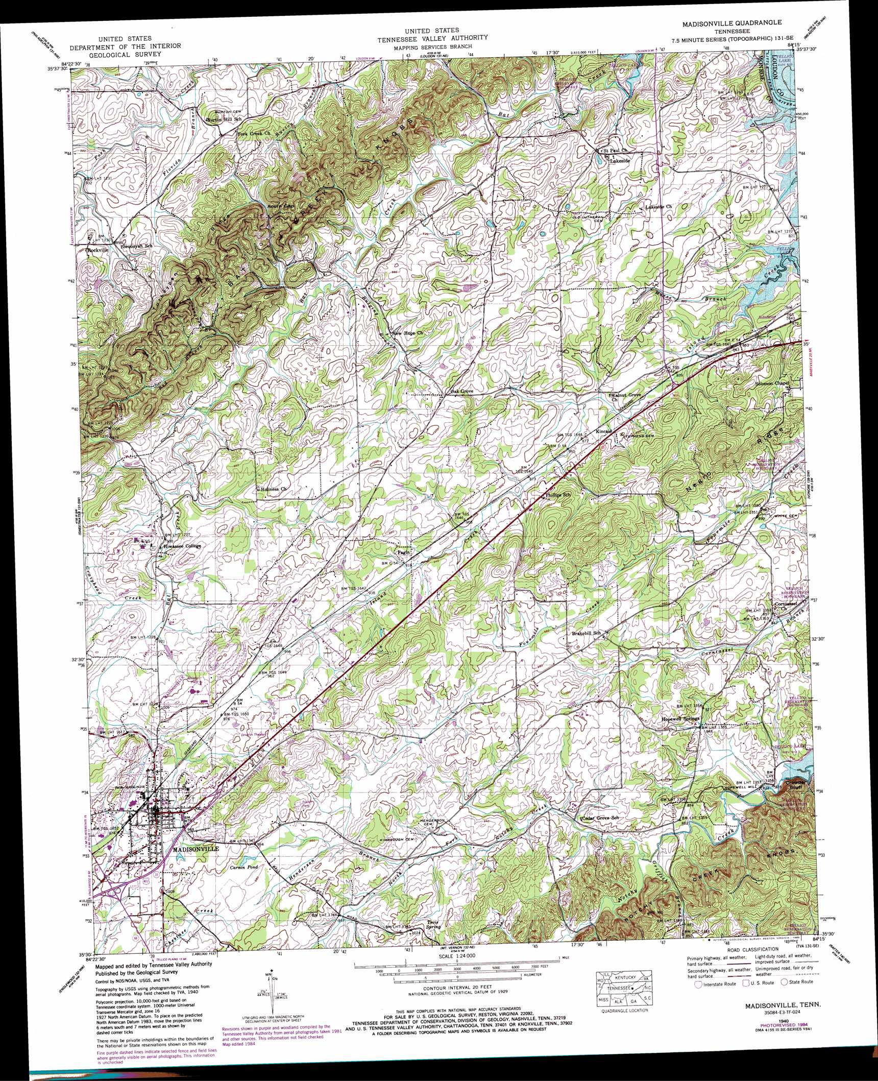
Madisonville Topo Map Tennessee
To zoom in, hover over the map of Madisonville
USGS Topo Quad 35084e3 - 1:24,000 scale
| Topo Map Name: | Madisonville |
| USGS Topo Quad ID: | 35084e3 |
| Print Size: | ca. 21 1/4" wide x 27" high |
| Southeast Coordinates: | 35.5° N latitude / 84.25° W longitude |
| Map Center Coordinates: | 35.5625° N latitude / 84.3125° W longitude |
| U.S. State: | TN |
| Filename: | o35084e3.jpg |
| Download Map JPG Image: | Madisonville topo map 1:24,000 scale |
| Map Type: | Topographic |
| Topo Series: | 7.5´ |
| Map Scale: | 1:24,000 |
| Source of Map Images: | United States Geological Survey (USGS) |
| Alternate Map Versions: |
Madisonville TN 1936 Download PDF Buy paper map Madisonville TN 1940 Download PDF Buy paper map Madisonville TN 1940, updated 1954 Download PDF Buy paper map Madisonville TN 1940, updated 1985 Download PDF Buy paper map Madisonville TN 1940, updated 1988 Download PDF Buy paper map Madisonville TN 1941 Download PDF Buy paper map Madisonville TN 2003, updated 2004 Download PDF Buy paper map Madisonville TN 2010 Download PDF Buy paper map Madisonville TN 2013 Download PDF Buy paper map Madisonville TN 2016 Download PDF Buy paper map |
| FStopo: | US Forest Service topo Madisonville is available: Download FStopo PDF Download FStopo TIF |
1:24,000 Topo Quads surrounding Madisonville
Bacon Gap |
Cave Creek |
Lenoir City |
Concord |
Louisville |
Pattie Gap |
Philadelphia |
Loudon |
Meadow |
Binfield |
Niota |
Sweetwater |
Madisonville |
Vonore |
Tallassee |
Athens |
Englewood |
Mount Vernon |
Rafter |
Whiteoak Flats |
Etowah |
Mecca |
Tellico Plains |
Bald River Falls |
Big Junction |
> Back to 35084e1 at 1:100,000 scale
> Back to 35084a1 at 1:250,000 scale
> Back to U.S. Topo Maps home
Madisonville topo map: Gazetteer
Madisonville: Cliffs
Crowder Bluff elevation 300m 984′Madisonville: Dams
Craighead Dam elevation 298m 977′Madisonville: Gaps
Acorn Gap elevation 301m 987′Madisonville: Lakes
Carson Pond elevation 298m 977′Madisonville: Populated Places
Brakebill (historical) elevation 277m 908′Fagin elevation 279m 915′
Hiwassee College elevation 290m 951′
Hopewell Mill elevation 250m 820′
Hopewell Springs elevation 259m 849′
Kincaid elevation 267m 875′
Lakeside elevation 289m 948′
Madisonville elevation 303m 994′
Oak Grove elevation 303m 994′
Phillips elevation 283m 928′
Rockville elevation 292m 958′
Madisonville: Reservoirs
Craighead Lake elevation 298m 977′Madisonville: Ridges
Negro Ridge elevation 381m 1250′Turkeypen Ridge elevation 415m 1361′
Madisonville: Springs
Blevins Spring elevation 277m 908′Tevis Spring elevation 293m 961′
Madisonville: Streams
Bulging Branch elevation 259m 849′Craighead Creek elevation 273m 895′
Florida Branch elevation 274m 898′
Griffith Branch elevation 256m 839′
Henderson Branch elevation 274m 898′
Little Notchy Creek elevation 258m 846′
Moree Branch elevation 248m 813′
North Fork Notchy Creek elevation 256m 839′
Red Branch elevation 261m 856′
Turkeypen Branch elevation 267m 875′
Madisonville: Summits
Bat Creek Knobs elevation 328m 1076′Madisonville digital topo map on disk
Buy this Madisonville topo map showing relief, roads, GPS coordinates and other geographical features, as a high-resolution digital map file on DVD: