Wauhatchie Topo Map Tennessee
To zoom in, hover over the map of Wauhatchie
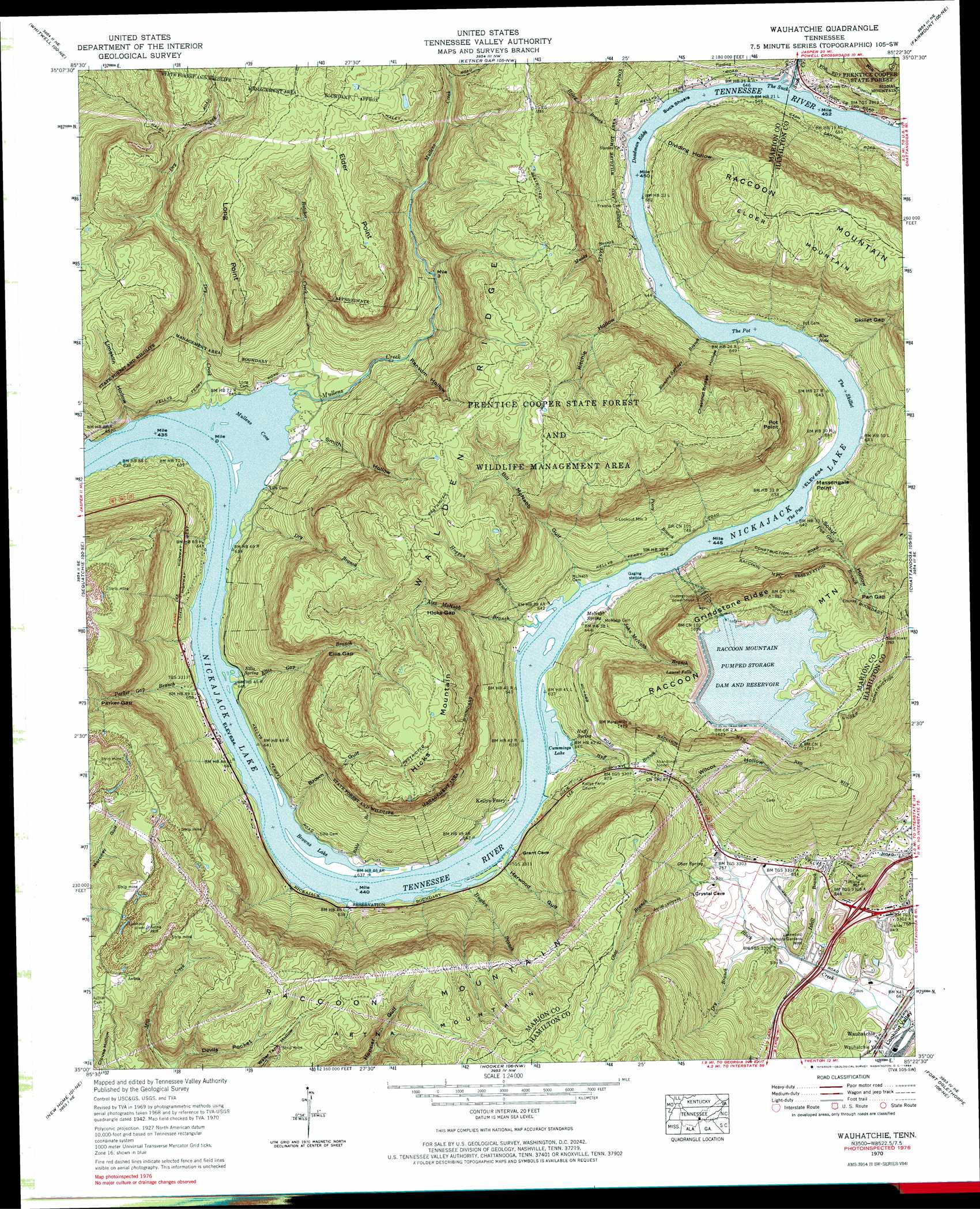
USGS Topo Quad 35085a4 - 1:24,000 scale
| Topo Map Name: | Wauhatchie |
| USGS Topo Quad ID: | 35085a4 |
| Print Size: | ca. 21 1/4" wide x 27" high |
| Southeast Coordinates: | 35° N latitude / 85.375° W longitude |
| Map Center Coordinates: | 35.0625° N latitude / 85.4375° W longitude |
| U.S. State: | TN |
| Filename: | o35085a4.jpg |
| Download Map JPG Image: | Wauhatchie topo map 1:24,000 scale |
| Map Type: | Topographic |
| Topo Series: | 7.5´ |
| Map Scale: | 1:24,000 |
| Source of Map Images: | United States Geological Survey (USGS) |
| Alternate Map Versions: |
Wauhatchie TN 1936 Download PDF Buy paper map Wauhatchie TN 1942, updated 1952 Download PDF Buy paper map Wauhatchie TN 1942, updated 1968 Download PDF Buy paper map Wauhatchie TN 1943 Download PDF Buy paper map Wauhatchie TN 1970, updated 1972 Download PDF Buy paper map Wauhatchie TN 1970, updated 1984 Download PDF Buy paper map Wauhatchie TN 1970, updated 1984 Download PDF Buy paper map Wauhatchie TN 2010 Download PDF Buy paper map Wauhatchie TN 2013 Download PDF Buy paper map Wauhatchie TN 2016 Download PDF Buy paper map |
1:24,000 Topo Quads surrounding Wauhatchie
Tracy City |
Palmer |
Daus |
Henson Gap |
Soddy |
White City |
Whitwell |
Ketner Gap |
Fairmount |
Daisy |
South Pittsburg |
Sequatchie |
Wauhatchie |
Chattanooga |
East Chattanooga |
Bridgeport |
New Home |
Hooker |
Fort Oglethorpe |
East Ridge |
Flat Rock |
Trenton |
Durham |
Kensington |
Nickajack Gap |
> Back to 35085a1 at 1:100,000 scale
> Back to 35084a1 at 1:250,000 scale
> Back to U.S. Topo Maps home
Wauhatchie topo map: Gazetteer
Wauhatchie: Areas
The Pan elevation 193m 633′The Pot elevation 193m 633′
The Skillet elevation 193m 633′
The Suck elevation 193m 633′
Wauhatchie: Bars
Kellys Bar elevation 193m 633′Suck Shoals elevation 193m 633′
Wauhatchie: Bays
Blue Hole elevation 196m 643′Mullens Cove elevation 193m 633′
Wauhatchie: Capes
Elder Point elevation 517m 1696′Long Point elevation 531m 1742′
Massengale Point elevation 195m 639′
Pot Point elevation 459m 1505′
Suck Point elevation 483m 1584′
Wauhatchie: Crossings
Halls Ferry (historical) elevation 193m 633′Interchange 174 elevation 235m 770′
Wauhatchie: Dams
Raccoon Mountain Pumped Station Dam elevation 509m 1669′Wauhatchie: Falls
Laurel Falls elevation 429m 1407′Wauhatchie: Gaps
Cummings Gap elevation 294m 964′Ellis Gap elevation 335m 1099′
Hicks Gap elevation 310m 1017′
Pan Gap elevation 404m 1325′
Parker Gap elevation 402m 1318′
Skillet Gap elevation 348m 1141′
Wauhatchie: Islands
Savannah Towhead elevation 195m 639′Wauhatchie: Lakes
Browns Lake elevation 193m 633′Cummings Lake elevation 193m 633′
Wauhatchie: Mines
Aetna Mines elevation 531m 1742′McNabb Mines elevation 222m 728′
Wauhatchie: Parks
Prentice Cooper State Forest and Wildlife Ma elevation 548m 1797′Prentice-Cooper State Forest and Wildlife Management Area elevation 548m 1797′
Wauhatchie: Populated Places
Shake Rag elevation 200m 656′Stanley elevation 210m 688′
Wauhatchie: Rapids
Deadman Eddy elevation 193m 633′Wauhatchie: Reservoirs
Raccoon Mountain Pumped Station Reserve elevation 509m 1669′Raccoon Mountain Pumped Station Reservoir elevation 509m 1669′
Wauhatchie: Ridges
Grindstone Ridge elevation 555m 1820′Wauhatchie: Springs
Ellis Spring elevation 200m 656′Huff Spring elevation 199m 652′
McNabb Spring elevation 196m 643′
Obar Spring elevation 229m 751′
Wauhatchie: Streams
Alex McNabb Branch elevation 193m 633′Bible Branch elevation 193m 633′
Blowing Springs Branch elevation 195m 639′
Butcher Creek elevation 193m 633′
Dry Branch elevation 195m 639′
Dry Branch elevation 208m 682′
Dry Creek elevation 195m 639′
Ellis Gap Branch elevation 193m 633′
Harwood Branch elevation 193m 633′
Hogpen Branch elevation 195m 639′
Huff Branch elevation 195m 639′
Hugden Branch elevation 195m 639′
Isbill Branch elevation 201m 659′
John McNabb Branch elevation 193m 633′
Laurel Branch (historical) elevation 445m 1459′
Moore Hollow Creek elevation 194m 636′
Muddy Branch elevation 195m 639′
Mullens Creek elevation 193m 633′
Obar Branch elevation 247m 810′
Pan Gap Branch elevation 195m 639′
Parker Gap Branch elevation 195m 639′
Piney Branch elevation 194m 636′
Suck Creek elevation 194m 636′
Wauhatchie: Summits
Elder Mountain elevation 569m 1866′Hicks Mountain elevation 551m 1807′
Wauhatchie: Valleys
Bill McNabb Gulf elevation 203m 666′Brown Gulf elevation 199m 652′
Chestnut Bridge Hollow elevation 208m 682′
Devils Pocket elevation 291m 954′
Dividing Hollow elevation 203m 666′
Harwood Gulf elevation 195m 639′
Limekiln Hollow elevation 207m 679′
Ransom Hollow elevation 226m 741′
Ritchie Hollow elevation 204m 669′
Scout Hollow elevation 211m 692′
Smith Hollow elevation 195m 639′
Wilcox Hollow elevation 269m 882′
Wauhatchie digital topo map on disk
Buy this Wauhatchie topo map showing relief, roads, GPS coordinates and other geographical features, as a high-resolution digital map file on DVD: