Sinking Cove Topo Map Tennessee
To zoom in, hover over the map of Sinking Cove
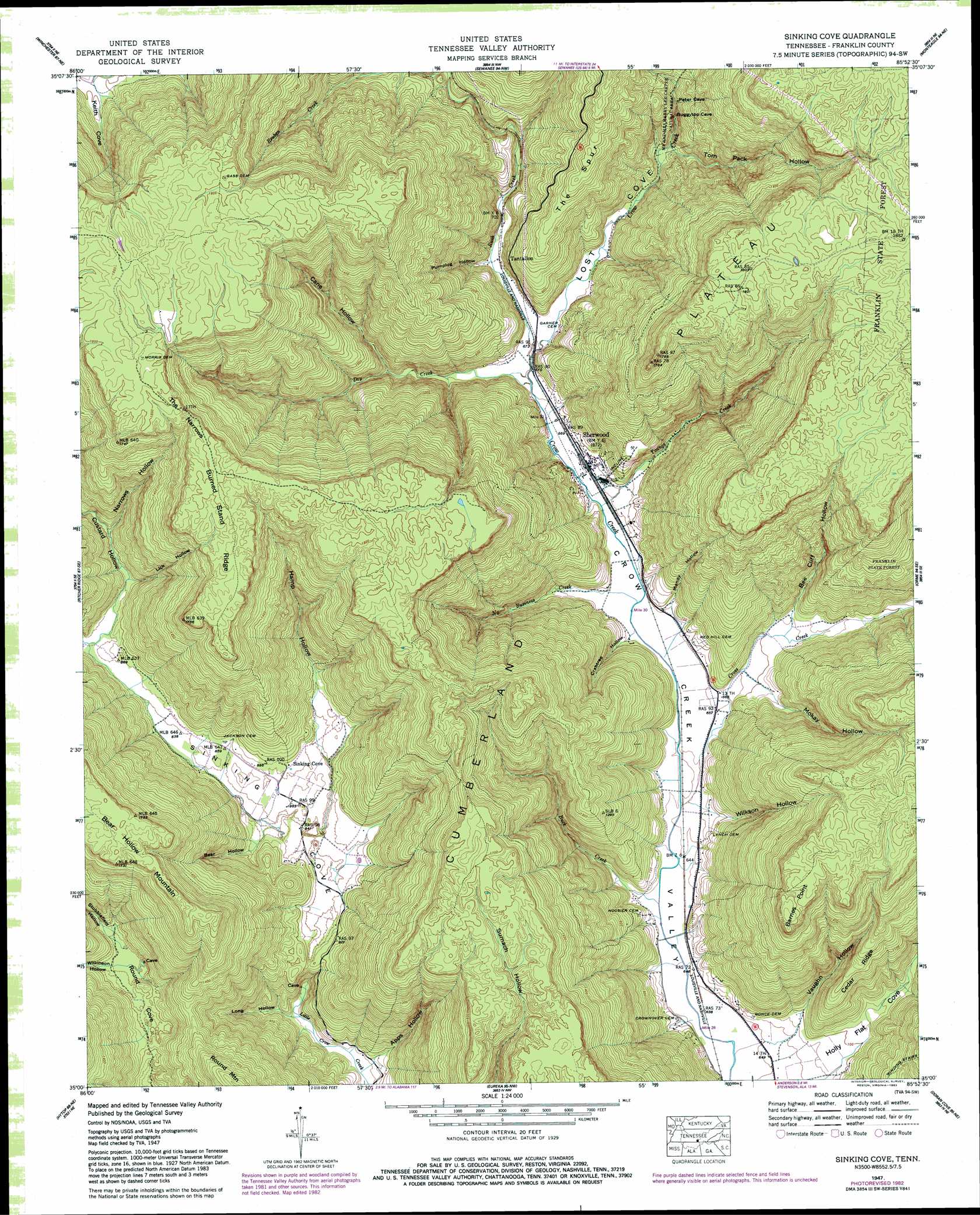
USGS Topo Quad 35085a8 - 1:24,000 scale
| Topo Map Name: | Sinking Cove |
| USGS Topo Quad ID: | 35085a8 |
| Print Size: | ca. 21 1/4" wide x 27" high |
| Southeast Coordinates: | 35° N latitude / 85.875° W longitude |
| Map Center Coordinates: | 35.0625° N latitude / 85.9375° W longitude |
| U.S. State: | TN |
| Filename: | o35085a8.jpg |
| Download Map JPG Image: | Sinking Cove topo map 1:24,000 scale |
| Map Type: | Topographic |
| Topo Series: | 7.5´ |
| Map Scale: | 1:24,000 |
| Source of Map Images: | United States Geological Survey (USGS) |
| Alternate Map Versions: |
Sinking Cove TN 1936 Download PDF Buy paper map Sinking Cove TN 1947, updated 1974 Download PDF Buy paper map Sinking Cove TN 1947, updated 1977 Download PDF Buy paper map Sinking Cove TN 1947, updated 1983 Download PDF Buy paper map Sinking Cove TN 1950 Download PDF Buy paper map Sinking Cove TN 2010 Download PDF Buy paper map Sinking Cove TN 2013 Download PDF Buy paper map Sinking Cove TN 2016 Download PDF Buy paper map |
1:24,000 Topo Quads surrounding Sinking Cove
Tullahoma |
Capitol Hill |
Alto |
Burrow Cove |
Tracy City |
Belvidere |
Winchester |
Sewanee |
Monteagle |
White City |
Beans Creek |
Pitcher Ridge |
Sinking Cove |
Orme |
South Pittsburg |
Estill Fork |
Hytop |
Eureka |
Doran Cove |
Bridgeport |
Princeton |
Mud Creek |
Wannville |
Stevenson |
Flat Rock |
> Back to 35085a1 at 1:100,000 scale
> Back to 35084a1 at 1:250,000 scale
> Back to U.S. Topo Maps home
Sinking Cove topo map: Gazetteer
Sinking Cove: Capes
Barnes Point elevation 522m 1712′Sinking Cove: Gaps
The Narrows elevation 529m 1735′Sinking Cove: Parks
Mister and Mrs Larry Lee Carter Natural Area elevation 296m 971′Sinking Cove: Populated Places
Sherwood elevation 204m 669′Tantallon elevation 260m 853′
Sinking Cove: Post Offices
Sherwood Post Office elevation 203m 666′Sinking Cove: Ridges
Burned Stand Ridge elevation 549m 1801′Cedar Ridge elevation 345m 1131′
The Spur elevation 438m 1437′
Sinking Cove: Streams
Brush Creek elevation 225m 738′Buck Creek elevation 193m 633′
Clark Branch Creek elevation 219m 718′
Cross Creek elevation 195m 639′
Dry Creek elevation 201m 659′
No Business Creek elevation 197m 646′
Rush Creek elevation 201m 659′
Vine Branch elevation 191m 626′
Youngs Creek elevation 199m 652′
Sinking Cove: Trails
Winding Stairs elevation 323m 1059′Sinking Cove: Valleys
Apps Hollow elevation 199m 652′Bear Hollow elevation 250m 820′
Bee Cliff Hollow elevation 223m 731′
Cane Hollow elevation 224m 734′
Crabtree Hollow elevation 200m 656′
Custard Hollow elevation 259m 849′
Hamp Hollow elevation 247m 810′
Lick Hollow elevation 267m 875′
Long Hollow elevation 198m 649′
Los Cove elevation 202m 662′
Mandy Hollow elevation 201m 659′
Mokay Hollow elevation 217m 711′
Narrows Hollow elevation 269m 882′
Pumplog Hollow elevation 206m 675′
Round Cove elevation 283m 928′
Sinking Cove elevation 239m 784′
Stubblefield Hollow elevation 282m 925′
Tom Pack Hollow elevation 228m 748′
Vaughn Hollow elevation 202m 662′
Wilkinson Hollow elevation 287m 941′
Wilkson Hollow elevation 202m 662′
Sinking Cove digital topo map on disk
Buy this Sinking Cove topo map showing relief, roads, GPS coordinates and other geographical features, as a high-resolution digital map file on DVD: