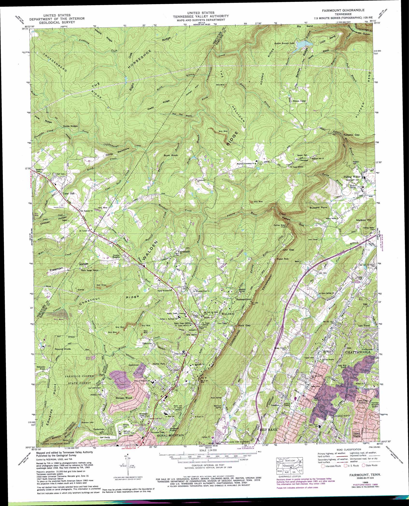
Fairmount Topo Map Tennessee
To zoom in, hover over the map of Fairmount
USGS Topo Quad 35085b3 - 1:24,000 scale
| Topo Map Name: | Fairmount |
| USGS Topo Quad ID: | 35085b3 |
| Print Size: | ca. 21 1/4" wide x 27" high |
| Southeast Coordinates: | 35.125° N latitude / 85.25° W longitude |
| Map Center Coordinates: | 35.1875° N latitude / 85.3125° W longitude |
| U.S. State: | TN |
| Filename: | o35085b3.jpg |
| Download Map JPG Image: | Fairmount topo map 1:24,000 scale |
| Map Type: | Topographic |
| Topo Series: | 7.5´ |
| Map Scale: | 1:24,000 |
| Source of Map Images: | United States Geological Survey (USGS) |
| Alternate Map Versions: |
Fairmount TN 1936 Download PDF Buy paper map Fairmount TN 1945, updated 1957 Download PDF Buy paper map Fairmount TN 1946, updated 1947 Download PDF Buy paper map Fairmount TN 1958, updated 1959 Download PDF Buy paper map Fairmount TN 1958, updated 1965 Download PDF Buy paper map Fairmount TN 1969, updated 1972 Download PDF Buy paper map Fairmount TN 1969, updated 1976 Download PDF Buy paper map Fairmount TN 1969, updated 1977 Download PDF Buy paper map Fairmount TN 1969, updated 1990 Download PDF Buy paper map Fairmount TN 1969, updated 1990 Download PDF Buy paper map Fairmount TN 2010 Download PDF Buy paper map Fairmount TN 2013 Download PDF Buy paper map Fairmount TN 2016 Download PDF Buy paper map |
1:24,000 Topo Quads surrounding Fairmount
Collins |
Savage Point |
Mount Airy |
Brayton |
Graysville |
Palmer |
Daus |
Henson Gap |
Soddy |
Grasshopper Creek |
Whitwell |
Ketner Gap |
Fairmount |
Daisy |
Snow Hill |
Sequatchie |
Wauhatchie |
Chattanooga |
East Chattanooga |
Ooltewah |
New Home |
Hooker |
Fort Oglethorpe |
East Ridge |
Ringgold |
> Back to 35085a1 at 1:100,000 scale
> Back to 35084a1 at 1:250,000 scale
> Back to U.S. Topo Maps home
Fairmount topo map: Gazetteer
Fairmount: Bends
Big Bend elevation 543m 1781′Little Bend elevation 517m 1696′
Fairmount: Capes
Buzzard Point elevation 250m 820′Wolfpen Point elevation 573m 1879′
Fairmount: Cliffs
Cumberland Escarpment elevation 484m 1587′Edwards Point elevation 528m 1732′
Fairmount: Dams
Boston Branch Lake Dam elevation 500m 1640′Fairmount: Falls
Falling Water Falls elevation 446m 1463′Fairmount: Forests
Prentice Cooper State Forest elevation 483m 1584′Fairmount: Gaps
Ford Gap elevation 583m 1912′Levi Gap elevation 496m 1627′
Roberts Gap elevation 433m 1420′
Fairmount: Lakes
Rainbow Lake elevation 438m 1437′Fairmount: Mines
Dill Mine elevation 566m 1856′Doc Spangle Mine elevation 541m 1774′
Richard Lewis Number Eight Mine elevation 565m 1853′
Tate Mine elevation 545m 1788′
Fairmount: Populated Places
Alpine Heights elevation 265m 869′Applewood elevation 573m 1879′
Birnam Wood elevation 597m 1958′
Brynewood Park elevation 253m 830′
Claridge elevation 592m 1942′
Cloverdale Estates elevation 236m 774′
Cross Creek elevation 229m 751′
Daytona Hills elevation 256m 839′
Dowler Heights elevation 609m 1998′
Eastwood Acres elevation 259m 849′
Edwards Point elevation 568m 1863′
Fair Meadows Mobile Home Park elevation 209m 685′
Fairmount elevation 594m 1948′
Falling Water elevation 210m 688′
Forest Park elevation 513m 1683′
Forestdale elevation 264m 866′
Galaxy Heights elevation 243m 797′
Golden Oaks Estates elevation 243m 797′
Hiddenbrook elevation 532m 1745′
Laurel Creek elevation 605m 1984′
Lone Oak elevation 611m 2004′
Metro Park elevation 249m 816′
Montclair South elevation 226m 741′
Morrison Springs elevation 222m 728′
Mountainwood elevation 264m 866′
Norcross Hills elevation 241m 790′
North Glen Estates elevation 227m 744′
Northwoods elevation 217m 711′
Oak Hill North elevation 272m 892′
Pine Hill elevation 282m 925′
Plaza Hills elevation 232m 761′
Rustic Villa elevation 586m 1922′
Shepherd Forest elevation 556m 1824′
Signal Terrace elevation 593m 1945′
Skyline Park elevation 595m 1952′
Springvale elevation 604m 1981′
Summertown elevation 572m 1876′
Timberlinks elevation 551m 1807′
Timesville elevation 538m 1765′
Walden elevation 580m 1902′
Webb Trailer Court elevation 234m 767′
Fairmount: Reservoirs
Boston Branch Lake elevation 500m 1640′Read Lake elevation 218m 715′
Fairmount: Ridges
Adams Ridge elevation 567m 1860′Barker Ridge elevation 552m 1811′
Chestnut Ridge elevation 574m 1883′
Devils Backbone elevation 554m 1817′
Eight Oak Ridge elevation 606m 1988′
Freeman Ridge elevation 616m 2020′
Fruedenberg Ridge elevation 622m 2040′
Gadd Ridge elevation 583m 1912′
Grayson Ridge elevation 618m 2027′
Pine Ridge elevation 603m 1978′
Fairmount: Springs
Barker Spring elevation 211m 692′Burnt Cabin Spring elevation 506m 1660′
Mabbit Spring elevation 558m 1830′
Morrison Spring elevation 225m 738′
Read Spring elevation 238m 780′
Fairmount: Streams
Bee Branch elevation 446m 1463′Boston Branch elevation 278m 912′
Brimer Creek elevation 534m 1751′
Brock Creek elevation 505m 1656′
Brown Branch elevation 587m 1925′
Bull Branch elevation 441m 1446′
Coal Bank Creek elevation 525m 1722′
Fairmount Branch elevation 498m 1633′
Frederick Creek elevation 529m 1735′
Frederick Creek elevation 529m 1735′
Fruedenberg Creek elevation 505m 1656′
Hatfield Creek elevation 523m 1715′
Hicks Branch elevation 482m 1581′
Hixson Branch elevation 434m 1423′
Holly Branch elevation 469m 1538′
Hurricane Branch elevation 490m 1607′
Little Falling Water Creek elevation 296m 971′
Maple Branch elevation 509m 1669′
Marshall Creek elevation 498m 1633′
McGrew Creek elevation 529m 1735′
Muddy Branch elevation 427m 1400′
Rocky Branch elevation 212m 695′
Rogers Creek elevation 279m 915′
Seed Tick Branch elevation 477m 1564′
Service Branch elevation 587m 1925′
Short Creek elevation 482m 1581′
Standifer Creek elevation 534m 1751′
Stanley Branch elevation 498m 1633′
Fairmount: Summits
Buck Knob elevation 595m 1952′Mailbox Hill elevation 270m 885′
Round Knob elevation 601m 1971′
The Hellican elevation 562m 1843′
The Horseshoe elevation 557m 1827′
Fairmount: Valleys
Chicken Hollow elevation 519m 1702′Pickett Gulf elevation 239m 784′
Fairmount digital topo map on disk
Buy this Fairmount topo map showing relief, roads, GPS coordinates and other geographical features, as a high-resolution digital map file on DVD: