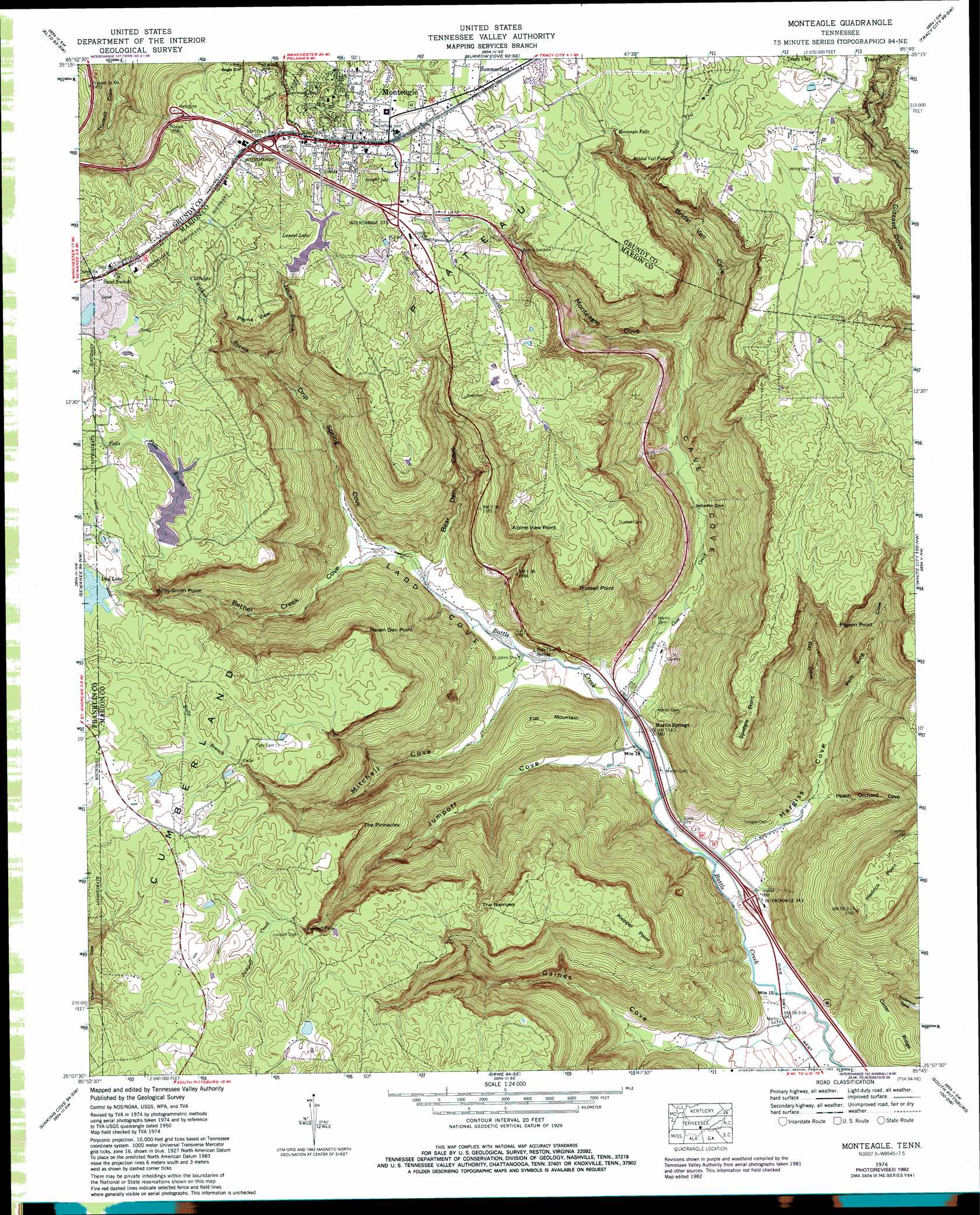
Monteagle Topo Map Tennessee
To zoom in, hover over the map of Monteagle
USGS Topo Quad 35085b7 - 1:24,000 scale
| Topo Map Name: | Monteagle |
| USGS Topo Quad ID: | 35085b7 |
| Print Size: | ca. 21 1/4" wide x 27" high |
| Southeast Coordinates: | 35.125° N latitude / 85.75° W longitude |
| Map Center Coordinates: | 35.1875° N latitude / 85.8125° W longitude |
| U.S. State: | TN |
| Filename: | o35085b7.jpg |
| Download Map JPG Image: | Monteagle topo map 1:24,000 scale |
| Map Type: | Topographic |
| Topo Series: | 7.5´ |
| Map Scale: | 1:24,000 |
| Source of Map Images: | United States Geological Survey (USGS) |
| Alternate Map Versions: |
Monteagle TN 1936 Download PDF Buy paper map Monteagle TN 1950 Download PDF Buy paper map Monteagle TN 1950, updated 1969 Download PDF Buy paper map Monteagle TN 1950, updated 1975 Download PDF Buy paper map Monteagle TN 1974, updated 1977 Download PDF Buy paper map Monteagle TN 1974, updated 1983 Download PDF Buy paper map Monteagle TN 1974, updated 1983 Download PDF Buy paper map Monteagle TN 2010 Download PDF Buy paper map Monteagle TN 2013 Download PDF Buy paper map Monteagle TN 2016 Download PDF Buy paper map |
1:24,000 Topo Quads surrounding Monteagle
Manchester |
Hillsboro |
Cane Hollow |
Altamont |
Collins |
Capitol Hill |
Alto |
Burrow Cove |
Tracy City |
Palmer |
Winchester |
Sewanee |
Monteagle |
White City |
Whitwell |
Pitcher Ridge |
Sinking Cove |
Orme |
South Pittsburg |
Sequatchie |
Hytop |
Eureka |
Doran Cove |
Bridgeport |
New Home |
> Back to 35085a1 at 1:100,000 scale
> Back to 35084a1 at 1:250,000 scale
> Back to U.S. Topo Maps home
Monteagle topo map: Gazetteer
Monteagle: Capes
Alpine View Point elevation 529m 1735′Hedrick Point elevation 527m 1729′
Kirby Smith Point elevation 550m 1804′
Klepper Point elevation 531m 1742′
Pigeon Point elevation 525m 1722′
Raven Den Point elevation 545m 1788′
Speegle Point elevation 530m 1738′
Trussell Point elevation 535m 1755′
Monteagle: Cliffs
Palisades elevation 554m 1817′Monteagle: Crossings
Interchange 134 elevation 584m 1916′Interchange 135 elevation 582m 1909′
Interchange 143 elevation 201m 659′
Monteagle: Dams
Clifftops Lake Dam elevation 554m 1817′Day Lake Dam elevation 552m 1811′
Tom McBee Dam elevation 553m 1814′
Monteagle: Falls
Bridal Veil Falls elevation 546m 1791′Jumpoff Falls elevation 515m 1689′
Monteagle Falls elevation 550m 1804′
Monteagle: Forests
Grundy State Forest elevation 515m 1689′Monteagle: Gaps
The Narrows elevation 524m 1719′Monteagle: Populated Places
Clifftops elevation 577m 1893′Martin Springs elevation 207m 679′
Monteagle elevation 586m 1922′
Monteagle: Reservoirs
Clifftops Lake elevation 554m 1817′Day Lake elevation 552m 1811′
Laurel Lake elevation 546m 1791′
Tom McBee Lake elevation 553m 1814′
Monteagle: Springs
Martin Springs elevation 207m 679′Tate Cave Spring elevation 219m 718′
Monteagle: Streams
Bethel Creek elevation 261m 856′Bridal Veil Creek elevation 443m 1453′
Cave Cove Creek elevation 212m 695′
Dripping Spring Cove Branch elevation 237m 777′
Falls Branch elevation 538m 1765′
Falls Branch elevation 432m 1417′
Gaines Cove Branch elevation 189m 620′
Hargiss Cove Branch elevation 196m 643′
Jumpoff Cove Branch elevation 200m 656′
Jumpoff Creek elevation 539m 1768′
Laurel Branch elevation 360m 1181′
Mitchell Cove Branch elevation 220m 721′
Monteagle Cove Branch elevation 298m 977′
Roy Cove Branch elevation 255m 836′
Wildcat Branch elevation 359m 1177′
Monteagle: Summits
Flat Mountain elevation 373m 1223′Payne View elevation 557m 1827′
The Pinnacles elevation 545m 1788′
Monteagle: Valleys
Bear Den Cove elevation 242m 793′Bethel Creek Cove elevation 257m 843′
Bridal Veil Cove elevation 325m 1066′
Cave Cove elevation 213m 698′
Drip Spring Cove elevation 256m 839′
Gaines Cove elevation 202m 662′
Hargiss Cove elevation 204m 669′
Jumpoff Cove elevation 216m 708′
Ladd Cove elevation 213m 698′
Mitchell Cove elevation 226m 741′
Monteagle Cove elevation 312m 1023′
Peach Orchard Cove elevation 241m 790′
Polly King Cove elevation 267m 875′
Ray Cove elevation 264m 866′
Monteagle digital topo map on disk
Buy this Monteagle topo map showing relief, roads, GPS coordinates and other geographical features, as a high-resolution digital map file on DVD: