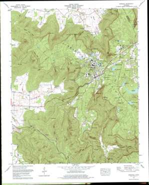
Sewanee Topo Map Tennessee
To zoom in, hover over the map of Sewanee
USGS Topo Quad 35085b8 - 1:24,000 scale
| Topo Map Name: | Sewanee |
| USGS Topo Quad ID: | 35085b8 |
| Print Size: | ca. 21 1/4" wide x 27" high |
| Southeast Coordinates: | 35.125° N latitude / 85.875° W longitude |
| Map Center Coordinates: | 35.1875° N latitude / 85.9375° W longitude |
| U.S. State: | TN |
| Filename: | o35085b8.jpg |
| Download Map JPG Image: | Sewanee topo map 1:24,000 scale |
| Map Type: | Topographic |
| Topo Series: | 7.5´ |
| Map Scale: | 1:24,000 |
| Source of Map Images: | United States Geological Survey (USGS) |
| Alternate Map Versions: |
Sewanee TN 1936 Download PDF Buy paper map Sewanee TN 1946, updated 1947 Download PDF Buy paper map Sewanee TN 1946, updated 1959 Download PDF Buy paper map Sewanee TN 1946, updated 1972 Download PDF Buy paper map Sewanee TN 1946, updated 1974 Download PDF Buy paper map Sewanee TN 1974, updated 1977 Download PDF Buy paper map Sewanee TN 1974, updated 1977 Download PDF Buy paper map Sewanee TN 2010 Download PDF Buy paper map Sewanee TN 2013 Download PDF Buy paper map Sewanee TN 2016 Download PDF Buy paper map |
1:24,000 Topo Quads surrounding Sewanee
> Back to 35085a1 at 1:100,000 scale
> Back to 35084a1 at 1:250,000 scale
> Back to U.S. Topo Maps home
Sewanee topo map: Gazetteer
Sewanee: Airports
Franklin County Airport elevation 591m 1938′Sewanee: Basins
Coolies Rift elevation 555m 1820′The Big Sink elevation 292m 958′
Sewanee: Capes
Cherry Point elevation 570m 1870′Dotson Point elevation 574m 1883′
Elliot Point elevation 574m 1883′
Kelleys Point elevation 552m 1811′
Piney Point elevation 584m 1916′
Point Disappointment elevation 557m 1827′
Rutledge Point elevation 572m 1876′
Tunnel Point elevation 552m 1811′
Sewanee: Cliffs
Armfield Bluff elevation 549m 1801′Morgans Steep elevation 558m 1830′
Sewanee: Dams
Athletic Field Dam elevation 586m 1922′Cheston Dam elevation 573m 1879′
Jackson Lake Dam elevation 564m 1850′
Lake O'Donnell Dam elevation 582m 1909′
Mont Milner Lake Dam elevation 568m 1863′
Saint Andrews Dam elevation 574m 1883′
Sewanee: Falls
Cascade Falls elevation 524m 1719′Sewanee: Gaps
The Saddle elevation 434m 1423′Sewanee: Mines
Arnett Mine elevation 523m 1715′Dodson Mine elevation 551m 1807′
Emile Huntzeker Mine elevation 537m 1761′
Kelley Mine elevation 532m 1745′
Rutledge Point Mine elevation 534m 1751′
Shakerag Hollow Mine elevation 548m 1797′
Sewanee: Plains
Sewanee Plateau elevation 583m 1912′Sewanee: Populated Places
Bobtown elevation 568m 1863′Midway elevation 609m 1998′
Roark Cove elevation 317m 1040′
Rockledge elevation 337m 1105′
Saint Andrews elevation 595m 1952′
Saint Marys elevation 563m 1847′
Sand Switch elevation 585m 1919′
Sewanee elevation 588m 1929′
Sewanee: Post Offices
Saint Andrews Post Office elevation 591m 1938′Sewanee Post Office elevation 574m 1883′
Sewanee: Reservoirs
Athletic Field Lake elevation 586m 1922′Eva Lake elevation 546m 1791′
Jackson Lake elevation 564m 1850′
Lake Cheston elevation 573m 1879′
Lake O'Donnell elevation 582m 1909′
Mont Milner Lake elevation 568m 1863′
Saint Andrews Lake elevation 574m 1883′
Sewanee: Ridges
Caldwell Ridge elevation 586m 1922′Lands End Ridge elevation 572m 1876′
Long Ridge elevation 465m 1525′
Sewanee: Springs
Big Spring elevation 309m 1013′Cherry Spring elevation 328m 1076′
Harrison Spring elevation 568m 1863′
Hawkins Spring elevation 305m 1000′
Kirk Spring elevation 307m 1007′
Long Spring elevation 323m 1059′
Pearson Spring elevation 308m 1010′
Prince Spring elevation 321m 1053′
Walker Spring elevation 320m 1049′
Sewanee: Streams
Barnes Branch elevation 366m 1200′Big Branch elevation 329m 1079′
Depot Branch elevation 400m 1312′
Kirby-Smith Branch elevation 301m 987′
Laurel Branch elevation 366m 1200′
Lost Creek elevation 299m 980′
Miller Creek elevation 291m 954′
Pinckney Branch elevation 330m 1082′
Reuben Creek elevation 249m 816′
Rose Branch elevation 522m 1712′
Talleys Fork elevation 258m 846′
Two Mile Branch elevation 334m 1095′
Wiggins Creek elevation 301m 987′
Sewanee: Summits
Cape of Good Hope elevation 558m 1830′Claibornes View elevation 578m 1896′
High Top elevation 574m 1883′
Otey View elevation 562m 1843′
Sewanee: Tunnels
Cowan Tunnel elevation 404m 1325′Sewanee: Valleys
Bennett Cove elevation 321m 1053′Billy Ought Hollow elevation 298m 977′
Cedar Hollow elevation 311m 1020′
Champion Cove elevation 298m 977′
Deep Hollow elevation 268m 879′
Dick Cove elevation 317m 1040′
Hawkins Cove elevation 298m 977′
Henley Hollow elevation 311m 1020′
Kirk Hollow elevation 323m 1059′
Little Cove elevation 304m 997′
Lost Cove elevation 295m 967′
Miller Cove elevation 304m 997′
Running Knob Hollow elevation 317m 1040′
Shakerag Hollow elevation 470m 1541′
Sewanee digital topo map on disk
Buy this Sewanee topo map showing relief, roads, GPS coordinates and other geographical features, as a high-resolution digital map file on DVD:


