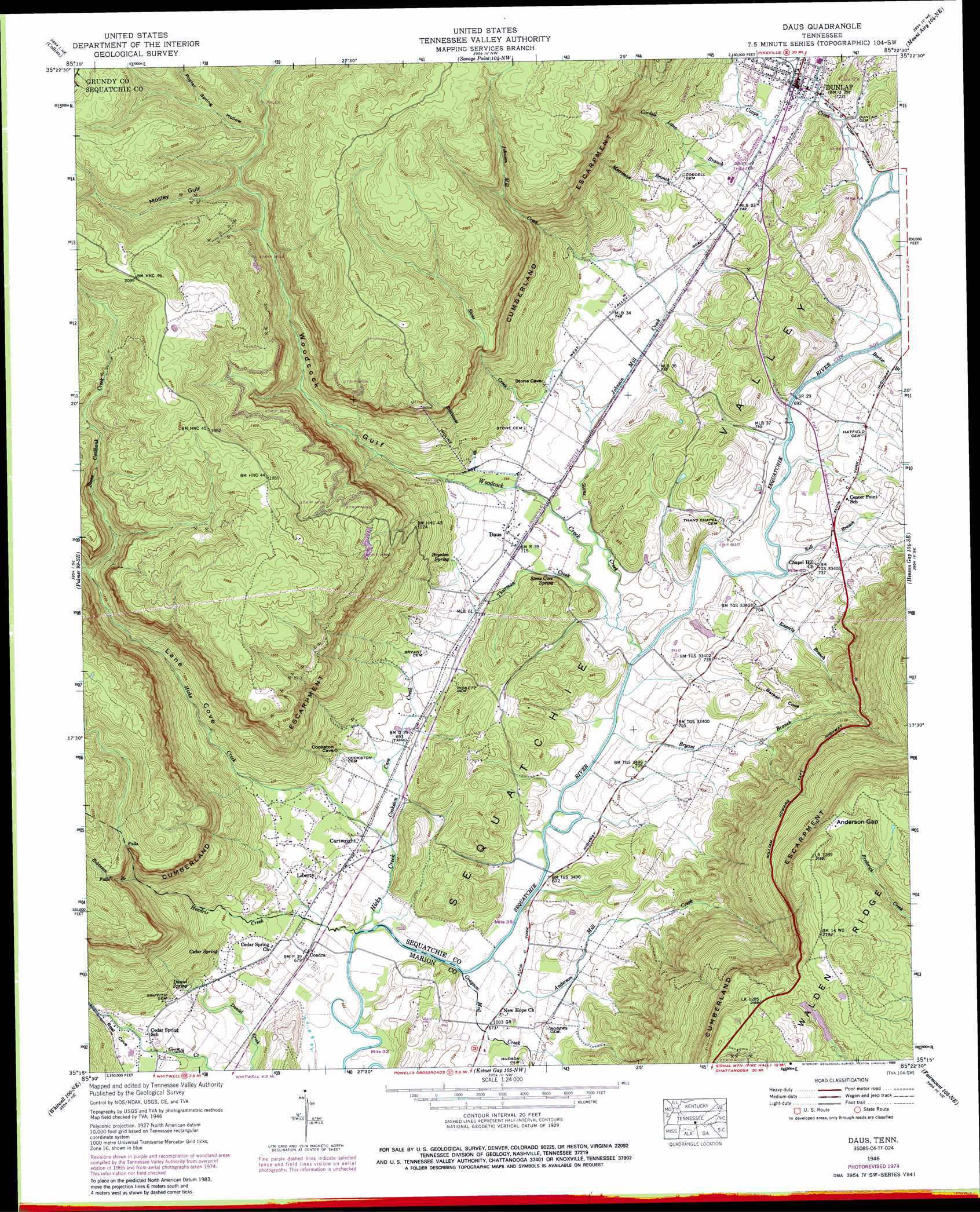
Daus Topo Map Tennessee
To zoom in, hover over the map of Daus
USGS Topo Quad 35085c4 - 1:24,000 scale
| Topo Map Name: | Daus |
| USGS Topo Quad ID: | 35085c4 |
| Print Size: | ca. 21 1/4" wide x 27" high |
| Southeast Coordinates: | 35.25° N latitude / 85.375° W longitude |
| Map Center Coordinates: | 35.3125° N latitude / 85.4375° W longitude |
| U.S. State: | TN |
| Filename: | o35085c4.jpg |
| Download Map JPG Image: | Daus topo map 1:24,000 scale |
| Map Type: | Topographic |
| Topo Series: | 7.5´ |
| Map Scale: | 1:24,000 |
| Source of Map Images: | United States Geological Survey (USGS) |
| Alternate Map Versions: |
Daus TN 1936 Download PDF Buy paper map Daus TN 1946, updated 1956 Download PDF Buy paper map Daus TN 1946, updated 1968 Download PDF Buy paper map Daus TN 1946, updated 1974 Download PDF Buy paper map Daus TN 1946, updated 1977 Download PDF Buy paper map Daus TN 1946, updated 1988 Download PDF Buy paper map Daus TN 1946, updated 1988 Download PDF Buy paper map Daus TN 1947, updated 1947 Download PDF Buy paper map Daus TN 2010 Download PDF Buy paper map Daus TN 2013 Download PDF Buy paper map Daus TN 2016 Download PDF Buy paper map |
1:24,000 Topo Quads surrounding Daus
Irving College |
Curtistown |
Smartt Mountain |
Brockdell |
Pikeville |
Altamont |
Collins |
Savage Point |
Mount Airy |
Brayton |
Tracy City |
Palmer |
Daus |
Henson Gap |
Soddy |
White City |
Whitwell |
Ketner Gap |
Fairmount |
Daisy |
South Pittsburg |
Sequatchie |
Wauhatchie |
Chattanooga |
East Chattanooga |
> Back to 35085a1 at 1:100,000 scale
> Back to 35084a1 at 1:250,000 scale
> Back to U.S. Topo Maps home
Daus topo map: Gazetteer
Daus: Dams
Ernest Taylor Dam elevation 600m 1968′Glen Barker Dam elevation 214m 702′
Daus: Gaps
Anderson Gap elevation 627m 2057′Daus: Populated Places
Bryant elevation 223m 731′Cartwright elevation 212m 695′
Cedar Springs elevation 219m 718′
Center Point elevation 225m 738′
Condra elevation 207m 679′
Daus elevation 217m 711′
Dunlap elevation 217m 711′
Liberty elevation 212m 695′
New Hope elevation 206m 675′
Daus: Reservoirs
Ernest Taylor Lake elevation 600m 1968′Glen Barker Lake elevation 214m 702′
Daus: Springs
Boynton Spring elevation 226m 741′Cedar Spring elevation 232m 761′
Daniel Spring elevation 244m 800′
Stone Cave Spring elevation 219m 718′
Daus: Streams
Anderson Mill Creek elevation 203m 666′Barker Branch elevation 207m 679′
Bryant Branch elevation 201m 659′
Cookston Cave Creek elevation 206m 675′
Coops Creek elevation 207m 679′
Cordell Lane Branch elevation 216m 708′
Easterly Branch elevation 207m 679′
Grayson Mill Creek elevation 202m 662′
Hendrix Creek elevation 201m 659′
Hicks Creek elevation 201m 659′
Johnson Mill Creek elevation 213m 698′
Kell Branch elevation 207m 679′
Kelley Creek elevation 370m 1213′
Merriman Branch elevation 227m 744′
Robinson Branch elevation 372m 1220′
Sourwood Creek elevation 487m 1597′
Stillhouse Branch elevation 216m 708′
Stone Coalbank Creek elevation 368m 1207′
Stone Creek elevation 207m 679′
Thurman Creek elevation 207m 679′
Woodcock Creek elevation 204m 669′
Daus: Valleys
Barker Cove elevation 211m 692′Lane Cove elevation 233m 764′
Mosley Gulf elevation 424m 1391′
Poplar Spring Hollow elevation 453m 1486′
Reel Cove elevation 223m 731′
Woodcock Gulf elevation 236m 774′
Daus digital topo map on disk
Buy this Daus topo map showing relief, roads, GPS coordinates and other geographical features, as a high-resolution digital map file on DVD: