Smartt Mountain Topo Map Tennessee
To zoom in, hover over the map of Smartt Mountain
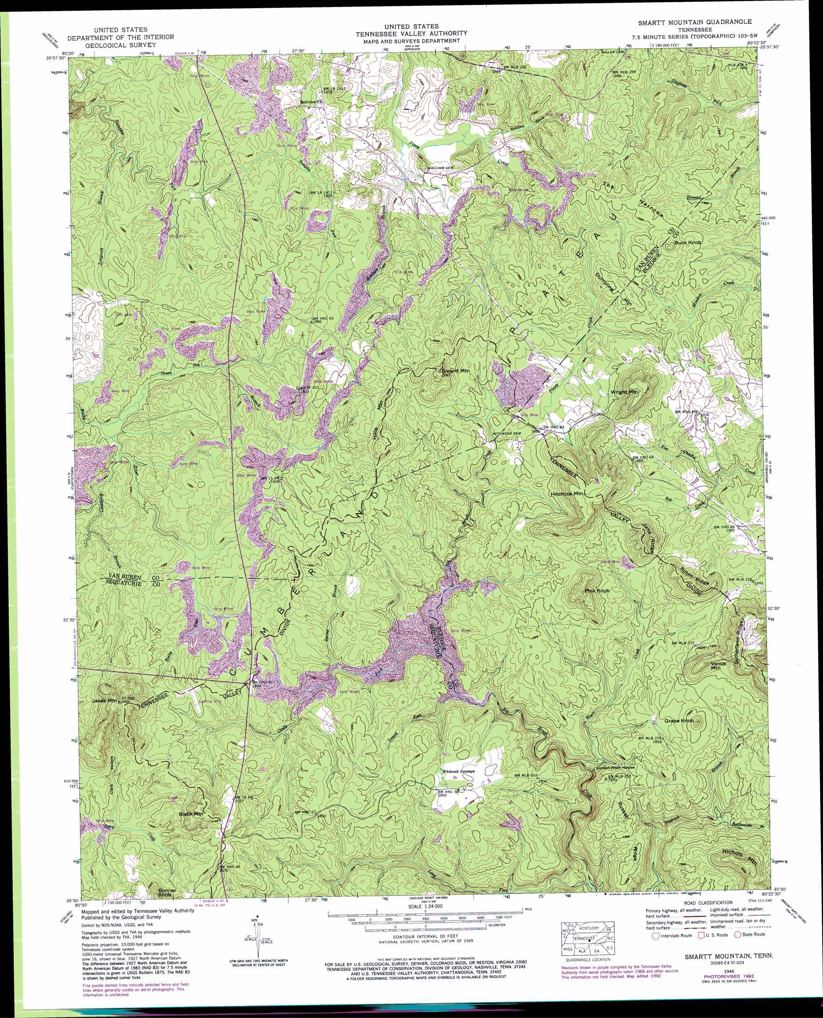
USGS Topo Quad 35085e4 - 1:24,000 scale
| Topo Map Name: | Smartt Mountain |
| USGS Topo Quad ID: | 35085e4 |
| Print Size: | ca. 21 1/4" wide x 27" high |
| Southeast Coordinates: | 35.5° N latitude / 85.375° W longitude |
| Map Center Coordinates: | 35.5625° N latitude / 85.4375° W longitude |
| U.S. State: | TN |
| Filename: | o35085e4.jpg |
| Download Map JPG Image: | Smartt Mountain topo map 1:24,000 scale |
| Map Type: | Topographic |
| Topo Series: | 7.5´ |
| Map Scale: | 1:24,000 |
| Source of Map Images: | United States Geological Survey (USGS) |
| Alternate Map Versions: |
Smart Mountain TN 1935 Download PDF Buy paper map Smartt Mountain TN 1946, updated 1962 Download PDF Buy paper map Smartt Mountain TN 1946, updated 1965 Download PDF Buy paper map Smartt Mountain TN 1946, updated 1977 Download PDF Buy paper map Smartt Mountain TN 1946, updated 1992 Download PDF Buy paper map Smartt Mountain TN 1947, updated 1948 Download PDF Buy paper map Smartt Mountain TN 2010 Download PDF Buy paper map Smartt Mountain TN 2013 Download PDF Buy paper map Smartt Mountain TN 2016 Download PDF Buy paper map |
1:24,000 Topo Quads surrounding Smartt Mountain
Campaign |
Doyle |
Bald Knob |
Lonewood |
Herbert Domain |
Cardwell Mountain |
Welchland |
Spencer |
Sampson |
Billingsley Gap |
Irving College |
Curtistown |
Smartt Mountain |
Brockdell |
Pikeville |
Altamont |
Collins |
Savage Point |
Mount Airy |
Brayton |
Tracy City |
Palmer |
Daus |
Henson Gap |
Soddy |
> Back to 35085e1 at 1:100,000 scale
> Back to 35084a1 at 1:250,000 scale
> Back to U.S. Topo Maps home
Smartt Mountain topo map: Gazetteer
Smartt Mountain: Dams
Studer Lake Dam elevation 553m 1814′Smartt Mountain: Mines
Smartt Mountain Mine elevation 568m 1863′Smartt Mountain: Pillars
Jordan Rock House elevation 518m 1699′Smartt Mountain: Populated Places
Hitchcox elevation 577m 1893′Olio (historical) elevation 569m 1866′
Smartt Mountain: Reservoirs
Studer Lake elevation 553m 1814′Smartt Mountain: Ridges
Jane Ridge elevation 641m 2103′Robin Ridge elevation 635m 2083′
Russell Ridge elevation 548m 1797′
Sutherland Ridge elevation 654m 2145′
The Narrows elevation 587m 1925′
Smartt Mountain: Streams
Baltimore Branch elevation 548m 1797′Bird Fork elevation 508m 1666′
Bird Fork elevation 544m 1784′
Blair Creek elevation 505m 1656′
Bob Creek elevation 539m 1768′
Bouldin Branch elevation 527m 1729′
Glady Fork elevation 524m 1719′
Green Sea Branch elevation 548m 1797′
Laurel Fork elevation 523m 1715′
Long Fork elevation 475m 1558′
Longrock Branch elevation 543m 1781′
Rattlesnake Branch elevation 515m 1689′
Spring Branch elevation 531m 1742′
Smartt Mountain: Summits
Black Mountain elevation 649m 2129′Bonner Knob elevation 644m 2112′
Buck Knob elevation 617m 2024′
Dumpling Mountain elevation 591m 1938′
Grape Knob elevation 611m 2004′
Hills Mountain elevation 622m 2040′
Hitchcox Mountain elevation 647m 2122′
Jakes Mountain elevation 670m 2198′
Pink Knob elevation 641m 2103′
Smartt Mountain elevation 645m 2116′
Vance Mountain elevation 632m 2073′
Wright Mountain elevation 649m 2129′
Smartt Mountain: Swamps
Whiteoak Swamps elevation 572m 1876′Smartt Mountain: Valleys
Clark Hollow elevation 562m 1843′Smiths Cove elevation 530m 1738′
Smartt Mountain digital topo map on disk
Buy this Smartt Mountain topo map showing relief, roads, GPS coordinates and other geographical features, as a high-resolution digital map file on DVD: