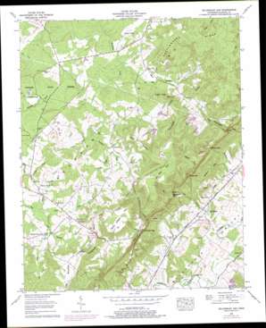
Billingsley Gap Topo Map Tennessee
To zoom in, hover over the map of Billingsley Gap
USGS Topo Quad 35085f2 - 1:24,000 scale
| Topo Map Name: | Billingsley Gap |
| USGS Topo Quad ID: | 35085f2 |
| Print Size: | ca. 21 1/4" wide x 27" high |
| Southeast Coordinates: | 35.625° N latitude / 85.125° W longitude |
| Map Center Coordinates: | 35.6875° N latitude / 85.1875° W longitude |
| U.S. State: | TN |
| Filename: | o35085f2.jpg |
| Download Map JPG Image: | Billingsley Gap topo map 1:24,000 scale |
| Map Type: | Topographic |
| Topo Series: | 7.5´ |
| Map Scale: | 1:24,000 |
| Source of Map Images: | United States Geological Survey (USGS) |
| Alternate Map Versions: |
Billingsley Gap TN 1935 Download PDF Buy paper map Billingsley Gap TN 1956, updated 1958 Download PDF Buy paper map Billingsley Gap TN 1956, updated 1974 Download PDF Buy paper map Billingsley Gap TN 1956, updated 1978 Download PDF Buy paper map Billingsley Gap TN 2010 Download PDF Buy paper map Billingsley Gap TN 2013 Download PDF Buy paper map Billingsley Gap TN 2016 Download PDF Buy paper map |
1:24,000 Topo Quads surrounding Billingsley Gap
> Back to 35085e1 at 1:100,000 scale
> Back to 35084a1 at 1:250,000 scale
> Back to U.S. Topo Maps home
Billingsley Gap topo map: Gazetteer
Billingsley Gap: Dams
Beecher Smith Dam elevation 533m 1748′Hugh Clayborne Dam elevation 524m 1719′
J C Gant Dam elevation 509m 1669′
Twin Lakes Number One Dam elevation 276m 905′
Twin Lakes Number Two Dam elevation 278m 912′
Billingsley Gap: Flats
Tamp Gilbert Flat elevation 615m 2017′Billingsley Gap: Forests
Bledsoe State Forest elevation 539m 1768′Billingsley Gap: Gaps
Billingsley Gap elevation 420m 1377′Rankins Gap elevation 451m 1479′
Shoemate Gap elevation 462m 1515′
Walker Gap elevation 393m 1289′
Billingsley Gap: Mines
Campbell Mine elevation 503m 1650′Billingsley Gap: Populated Places
Bellview elevation 530m 1738′Cold Spring elevation 267m 875′
Cooper Mill elevation 256m 839′
Emery Mill elevation 485m 1591′
Gladecreek (historical) elevation 527m 1729′
Hart (historical) elevation 538m 1765′
Mount Crest elevation 525m 1722′
Pearson (historical) elevation 536m 1758′
Saratoga Springs elevation 525m 1722′
Schoolfield (historical) elevation 533m 1748′
Seals (historical) elevation 533m 1748′
Tiptop elevation 612m 2007′
Billingsley Gap: Reservoirs
Beecher Smith Lake elevation 533m 1748′Hugh Clayborne Lake elevation 524m 1719′
J C Gant Lake elevation 509m 1669′
Twin Lakes Number One Lake elevation 276m 905′
Twin Lakes Number Two Lake elevation 278m 912′
Billingsley Gap: Ridges
Devils Racepath elevation 604m 1981′Rattlesnake Ridge elevation 617m 2024′
Billingsley Gap: Streams
Coalbank Creek elevation 517m 1696′Cold Spring Cove Branch elevation 258m 846′
Hall Creek elevation 250m 820′
Little Beaverdam Creek elevation 503m 1650′
Panter Creek elevation 515m 1689′
Thompson Creek elevation 518m 1699′
Watterman Branch elevation 512m 1679′
Wheeler Branch elevation 514m 1686′
Wolfpen Creek elevation 513m 1683′
Billingsley Gap: Summits
Cowen Knob elevation 574m 1883′Nussom Knob elevation 603m 1978′
Raven Rock elevation 524m 1719′
Billingsley Gap: Valleys
Lucy Cove elevation 269m 882′Rankins Cove elevation 274m 898′
Swafford Cove elevation 282m 925′
Tom Hale Gulf elevation 271m 889′
Walker Cove elevation 474m 1555′
Billingsley Gap digital topo map on disk
Buy this Billingsley Gap topo map showing relief, roads, GPS coordinates and other geographical features, as a high-resolution digital map file on DVD:


