Cardwell Mountain Topo Map Tennessee
To zoom in, hover over the map of Cardwell Mountain
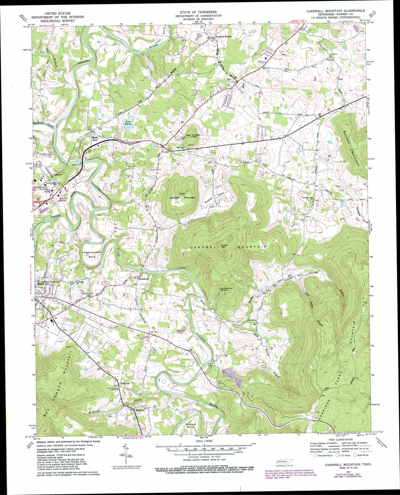
USGS Topo Quad 35085f6 - 1:24,000 scale
| Topo Map Name: | Cardwell Mountain |
| USGS Topo Quad ID: | 35085f6 |
| Print Size: | ca. 21 1/4" wide x 27" high |
| Southeast Coordinates: | 35.625° N latitude / 85.625° W longitude |
| Map Center Coordinates: | 35.6875° N latitude / 85.6875° W longitude |
| U.S. State: | TN |
| Filename: | o35085f6.jpg |
| Download Map JPG Image: | Cardwell Mountain topo map 1:24,000 scale |
| Map Type: | Topographic |
| Topo Series: | 7.5´ |
| Map Scale: | 1:24,000 |
| Source of Map Images: | United States Geological Survey (USGS) |
| Alternate Map Versions: |
Cardwell Mountain TN 1957, updated 1961 Download PDF Buy paper map Cardwell Mountain TN 1957, updated 1973 Download PDF Buy paper map Cardwell Mountain TN 1957, updated 1979 Download PDF Buy paper map Cardwell Mountain TN 1957, updated 1987 Download PDF Buy paper map Cardwell Mountain TN 2010 Download PDF Buy paper map Cardwell Mountain TN 2013 Download PDF Buy paper map Cardwell Mountain TN 2016 Download PDF Buy paper map |
1:24,000 Topo Quads surrounding Cardwell Mountain
Gassaway |
Smithville |
Sligo Bridge |
Cassville |
Sparta |
Short Mountain |
Dibrell |
Campaign |
Doyle |
Bald Knob |
Centertown |
Mcminnville |
Cardwell Mountain |
Welchland |
Spencer |
Morrison |
Viola |
Irving College |
Curtistown |
Smartt Mountain |
Hillsboro |
Cane Hollow |
Altamont |
Collins |
Savage Point |
> Back to 35085e1 at 1:100,000 scale
> Back to 35084a1 at 1:250,000 scale
> Back to U.S. Topo Maps home
Cardwell Mountain topo map: Gazetteer
Cardwell Mountain: Bends
Higgenbottom Bend elevation 268m 879′Lock Bend elevation 257m 843′
Turners Bend elevation 277m 908′
Cardwell Mountain: Crossings
Blacks Ferry (historical) elevation 252m 826′Cardwell Mountain: Lakes
Lake Karen elevation 286m 938′Cardwell Mountain: Populated Places
Fairview elevation 305m 1000′Groves (historical) elevation 280m 918′
Rowland elevation 298m 977′
Shady Rest elevation 295m 967′
Shellsford elevation 281m 921′
Smyrna elevation 300m 984′
Union elevation 287m 941′
Cardwell Mountain: Springs
Powder Mill Springs elevation 314m 1030′Cardwell Mountain: Streams
Barren Fork elevation 253m 830′Cane Hollow Branch elevation 287m 941′
Charles Creek elevation 247m 810′
Dark Hollow Branch elevation 265m 869′
Dry Branch elevation 246m 807′
Left Fork Dry Branch elevation 263m 862′
McGregor Creek elevation 260m 853′
Mud Creek elevation 271m 889′
Powder Mill Branch elevation 265m 869′
Rams Creek elevation 261m 856′
Right Fork Dry Branch elevation 263m 862′
Cardwell Mountain: Summits
Cardwell Mountain elevation 576m 1889′Grassy Mountain elevation 367m 1204′
Little Cardwell Mountain elevation 415m 1361′
Cardwell Mountain: Valleys
Blue Spring Cove elevation 282m 925′Douglas Cove elevation 295m 967′
McGee Cove elevation 299m 980′
Powder Mill Hollow elevation 265m 869′
Cardwell Mountain digital topo map on disk
Buy this Cardwell Mountain topo map showing relief, roads, GPS coordinates and other geographical features, as a high-resolution digital map file on DVD: