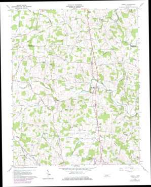
Dibrell Topo Map Tennessee
To zoom in, hover over the map of Dibrell
USGS Topo Quad 35085g7 - 1:24,000 scale
| Topo Map Name: | Dibrell |
| USGS Topo Quad ID: | 35085g7 |
| Print Size: | ca. 21 1/4" wide x 27" high |
| Southeast Coordinates: | 35.75° N latitude / 85.75° W longitude |
| Map Center Coordinates: | 35.8125° N latitude / 85.8125° W longitude |
| U.S. State: | TN |
| Filename: | o35085g7.jpg |
| Download Map JPG Image: | Dibrell topo map 1:24,000 scale |
| Map Type: | Topographic |
| Topo Series: | 7.5´ |
| Map Scale: | 1:24,000 |
| Source of Map Images: | United States Geological Survey (USGS) |
| Alternate Map Versions: |
Dibrell TN 1960, updated 1961 Download PDF Buy paper map Dibrell TN 1960, updated 1976 Download PDF Buy paper map Dibrell TN 1960, updated 1979 Download PDF Buy paper map Dibrell TN 2010 Download PDF Buy paper map Dibrell TN 2013 Download PDF Buy paper map Dibrell TN 2016 Download PDF Buy paper map |
1:24,000 Topo Quads surrounding Dibrell
> Back to 35085e1 at 1:100,000 scale
> Back to 35084a1 at 1:250,000 scale
> Back to U.S. Topo Maps home
Dibrell topo map: Gazetteer
Dibrell: Populated Places
Bear Branch (historical) elevation 294m 964′Bethel elevation 323m 1059′
Bluff Springs elevation 302m 990′
Dibrell elevation 293m 961′
Earleyville elevation 317m 1040′
Evanston (historical) elevation 322m 1056′
Gath elevation 311m 1020′
Green Hill elevation 310m 1017′
Lucky elevation 318m 1043′
Magnum (historical) elevation 337m 1105′
Womack elevation 323m 1059′
Dibrell: Streams
Bluff Springs Branch elevation 272m 892′Clear Springs Branch elevation 290m 951′
Devenport Creek elevation 303m 994′
Dry Branch elevation 310m 1017′
Gath Branch elevation 264m 866′
Jones Branch elevation 303m 994′
Long Hollow Branch elevation 297m 974′
Warren County Branch elevation 290m 951′
Dibrell: Swamps
Mizer Swamp elevation 315m 1033′Dibrell digital topo map on disk
Buy this Dibrell topo map showing relief, roads, GPS coordinates and other geographical features, as a high-resolution digital map file on DVD:


