Beans Creek Topo Map Tennessee
To zoom in, hover over the map of Beans Creek
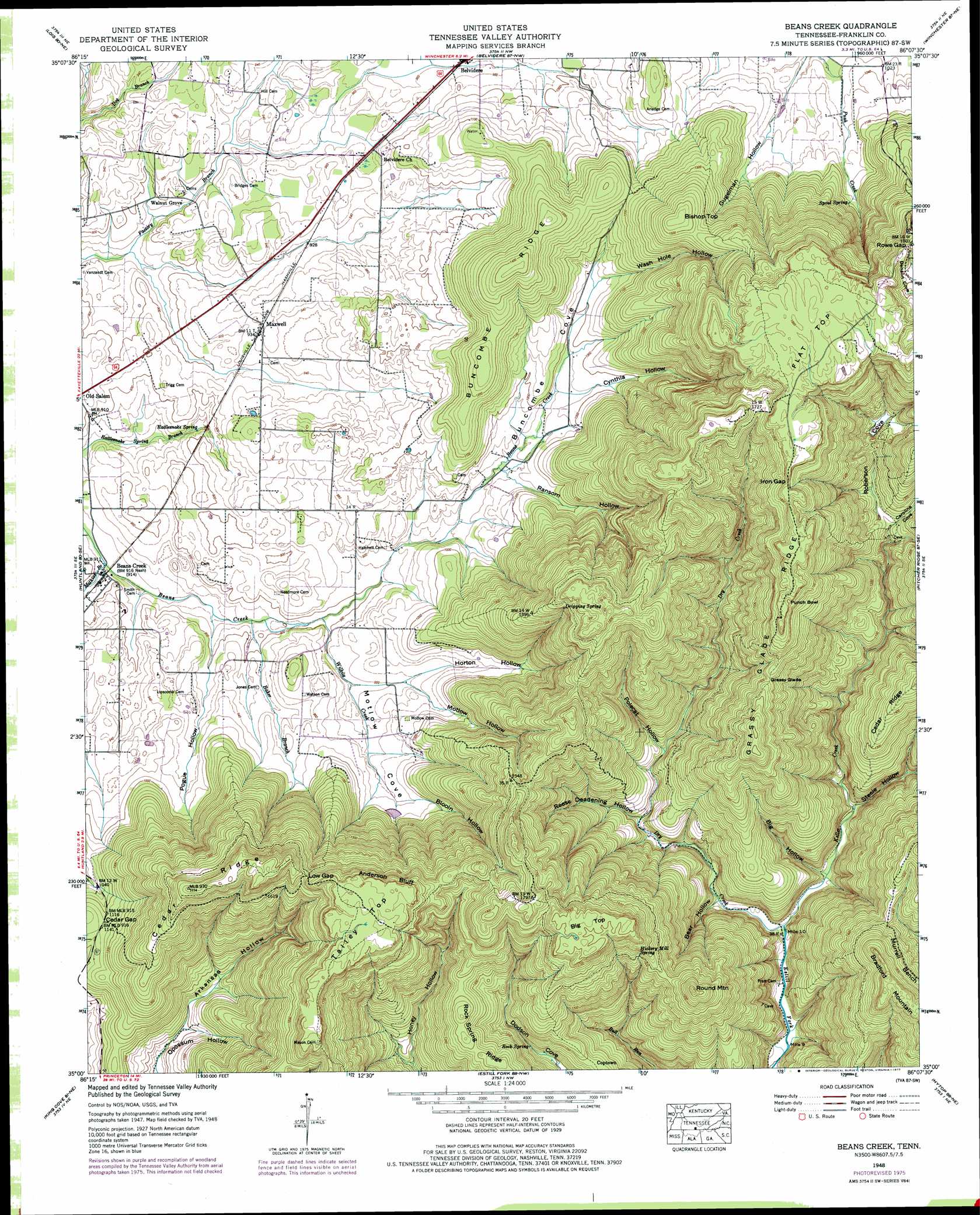
USGS Topo Quad 35086a2 - 1:24,000 scale
| Topo Map Name: | Beans Creek |
| USGS Topo Quad ID: | 35086a2 |
| Print Size: | ca. 21 1/4" wide x 27" high |
| Southeast Coordinates: | 35° N latitude / 86.125° W longitude |
| Map Center Coordinates: | 35.0625° N latitude / 86.1875° W longitude |
| U.S. State: | TN |
| Filename: | o35086a2.jpg |
| Download Map JPG Image: | Beans Creek topo map 1:24,000 scale |
| Map Type: | Topographic |
| Topo Series: | 7.5´ |
| Map Scale: | 1:24,000 |
| Source of Map Images: | United States Geological Survey (USGS) |
| Alternate Map Versions: |
Beans Creek TN 1936 Download PDF Buy paper map Beans Creek TN 1948, updated 1974 Download PDF Buy paper map Beans Creek TN 1948, updated 1977 Download PDF Buy paper map Beans Creek TN 1951 Download PDF Buy paper map Beans Creek TN 2010 Download PDF Buy paper map Beans Creek TN 2013 Download PDF Buy paper map Beans Creek TN 2016 Download PDF Buy paper map |
1:24,000 Topo Quads surrounding Beans Creek
Lynchburg West |
Lynchburg East |
Tullahoma |
Capitol Hill |
Alto |
Mulberry |
Lois |
Belvidere |
Winchester |
Sewanee |
Flintville |
Huntland |
Beans Creek |
Pitcher Ridge |
Sinking Cove |
New Market |
King Cove |
Estill Fork |
Hytop |
Eureka |
Maysville |
Hollytree |
Princeton |
Mud Creek |
Wannville |
> Back to 35086a1 at 1:100,000 scale
> Back to 35086a1 at 1:250,000 scale
> Back to U.S. Topo Maps home
Beans Creek topo map: Gazetteer
Beans Creek: Basins
Punch Bowl elevation 547m 1794′Beans Creek: Cliffs
Anderson Bluff elevation 532m 1745′Beans Creek: Flats
Grassy Glade elevation 468m 1535′Beans Creek: Gaps
Buncombe Gap elevation 368m 1207′Cedar Gap elevation 344m 1128′
Iron Gap elevation 554m 1817′
Low Gap elevation 512m 1679′
Rowe Gap elevation 546m 1791′
Beans Creek: Populated Places
Beans Creek elevation 267m 875′Coptown elevation 363m 1190′
Hickory Grove elevation 297m 974′
Maxwell elevation 285m 935′
Walnut Grove elevation 274m 898′
Beans Creek: Ridges
Buncombe Ridge elevation 433m 1420′Cedar Ridge elevation 356m 1167′
Cedar Ridge elevation 459m 1505′
Grassy Glade Ridge elevation 566m 1856′
Rock Spring Ridge elevation 421m 1381′
Beans Creek: Springs
Dripping Spring elevation 510m 1673′Hickory Mill Spring elevation 467m 1532′
Rattlesnake Spring elevation 265m 869′
Rock Spring elevation 327m 1072′
Spout Spring elevation 331m 1085′
Beans Creek: Streams
Baker Branch elevation 267m 875′Dog Branch elevation 276m 905′
Dry Creek elevation 219m 718′
Keller Creek elevation 219m 718′
Mathias Branch elevation 259m 849′
Wilhie Creek elevation 271m 889′
Beans Creek: Summits
Big Top elevation 555m 1820′Bishop Top elevation 472m 1548′
Bradford Mountain elevation 544m 1784′
Flat Top elevation 567m 1860′
Round Mountain elevation 527m 1729′
Talley Top elevation 558m 1830′
Beans Creek: Valleys
Arkansas Hollow elevation 269m 882′Bear Hollow elevation 230m 754′
Big Hollow elevation 225m 738′
Blooin Hollow elevation 295m 967′
Buncombe Cove elevation 282m 925′
Caroline Cove elevation 341m 1118′
Cynthia Hollow elevation 300m 984′
Gugelman Hollow elevation 314m 1030′
Horton Hollow elevation 284m 931′
Motlow Cove elevation 275m 902′
Motlow Hollow elevation 287m 941′
Pogue Hollow elevation 267m 875′
Polecat Hollow elevation 291m 954′
Ransom Hollow elevation 292m 958′
Reese Deadening Hollow elevation 254m 833′
Roberson Cove elevation 342m 1122′
Steele Hollow elevation 237m 777′
Wash Hole Hollow elevation 311m 1020′
Beans Creek digital topo map on disk
Buy this Beans Creek topo map showing relief, roads, GPS coordinates and other geographical features, as a high-resolution digital map file on DVD: