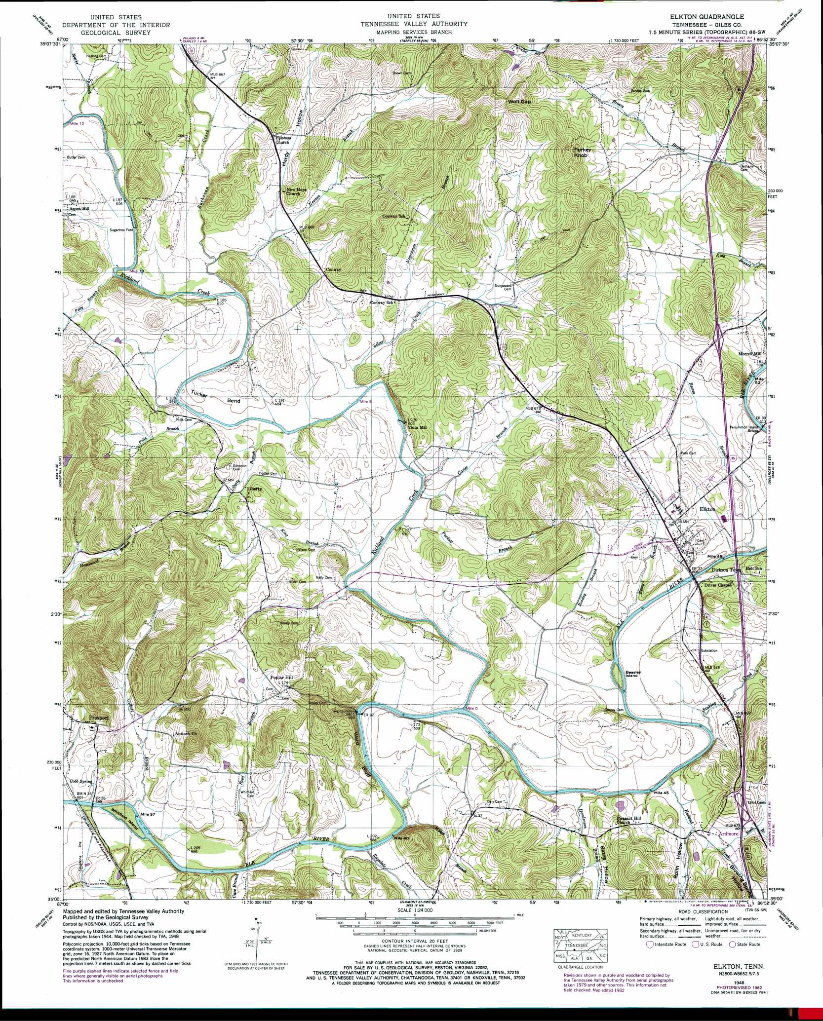
Elkton Topo Map Tennessee
To zoom in, hover over the map of Elkton
USGS Topo Quad 35086a8 - 1:24,000 scale
| Topo Map Name: | Elkton |
| USGS Topo Quad ID: | 35086a8 |
| Print Size: | ca. 21 1/4" wide x 27" high |
| Southeast Coordinates: | 35° N latitude / 86.875° W longitude |
| Map Center Coordinates: | 35.0625° N latitude / 86.9375° W longitude |
| U.S. State: | TN |
| Filename: | o35086a8.jpg |
| Download Map JPG Image: | Elkton topo map 1:24,000 scale |
| Map Type: | Topographic |
| Topo Series: | 7.5´ |
| Map Scale: | 1:24,000 |
| Source of Map Images: | United States Geological Survey (USGS) |
| Alternate Map Versions: |
Elkton TN 1936 Download PDF Buy paper map Elkton TN 1948, updated 1982 Download PDF Buy paper map Elkton TN 1951 Download PDF Buy paper map Elkton TN 1951, updated 1967 Download PDF Buy paper map Elkton TN 2010 Download PDF Buy paper map Elkton TN 2013 Download PDF Buy paper map Elkton TN 2016 Download PDF Buy paper map |
1:24,000 Topo Quads surrounding Elkton
Campbellsville |
Milky Way |
Brick Church |
Cornersville |
Petersburg |
Bodenham |
Pulaski |
Tarpley |
Frankewing |
Boonshill |
Appleton |
Aspen Hill |
Elkton |
Dellrose |
Taft |
Union Hill |
Salem |
Elkmont |
Ardmore |
Toney |
Cairo |
Ripley |
Athens |
Capshaw |
Jeff |
> Back to 35086a1 at 1:100,000 scale
> Back to 35086a1 at 1:250,000 scale
> Back to U.S. Topo Maps home
Elkton topo map: Gazetteer
Elkton: Bends
Tucker Bend elevation 185m 606′Elkton: Bridges
Persimmon Island Bridge elevation 181m 593′Elkton: Cliffs
Ward Bluff elevation 177m 580′Elkton: Crossings
Interchange 1 elevation 205m 672′Interchange 6 elevation 195m 639′
Sugartree Ford elevation 179m 587′
Elkton: Gaps
Wolf Gap elevation 278m 912′Elkton: Islands
Beasley Island elevation 182m 597′Whitfield Island elevation 174m 570′
Elkton: Populated Places
Conway elevation 212m 695′Dickson Town elevation 191m 626′
Elkton elevation 200m 656′
Liberty elevation 193m 633′
Lower Elkton (historical) elevation 184m 603′
Poplar Hill elevation 220m 721′
Vinta Mill elevation 186m 610′
Elkton: Post Offices
Elkton Post Office elevation 201m 659′Prospect Post Office elevation 197m 646′
Elkton: Springs
Cobb Spring elevation 181m 593′Elkton: Streams
Beasley Branch elevation 176m 577′Beaty Branch elevation 176m 577′
Brown Branch elevation 194m 636′
Buchanan Creek elevation 180m 590′
Carter Branch elevation 180m 590′
Cave Branch elevation 174m 570′
Cave Branch elevation 174m 570′
Ezell Branch elevation 185m 606′
Gilbert Branch elevation 174m 570′
Haden Branch elevation 178m 583′
Henderson Branch elevation 176m 577′
Holland Creek elevation 177m 580′
King Branch elevation 177m 580′
Liberty Branch elevation 180m 590′
Marks Branch elevation 181m 593′
Negrotown Branch elevation 183m 600′
Newton Branch elevation 182m 597′
Petty Branch elevation 180m 590′
Potts Branch elevation 180m 590′
Puckett Branch elevation 178m 583′
Ragsdale Creek elevation 177m 580′
Ragsdale Creek elevation 177m 580′
Reed Branch elevation 174m 570′
Reeves Branch elevation 176m 577′
Richland Creek elevation 177m 580′
Silver Creek elevation 178m 583′
Sinking Creek elevation 177m 580′
Elkton: Summits
Turkey Knob elevation 286m 938′Elkton: Valleys
Blowing Spring Hollow elevation 189m 620′Blowing Spring Hollow elevation 189m 620′
Hardy Hollow elevation 193m 633′
James Hollow elevation 190m 623′
Moore Hollow elevation 181m 593′
Moore Hollow elevation 181m 593′
Rolin Hollow elevation 182m 597′
Rolin Hollow elevation 182m 597′
Elkton digital topo map on disk
Buy this Elkton topo map showing relief, roads, GPS coordinates and other geographical features, as a high-resolution digital map file on DVD: