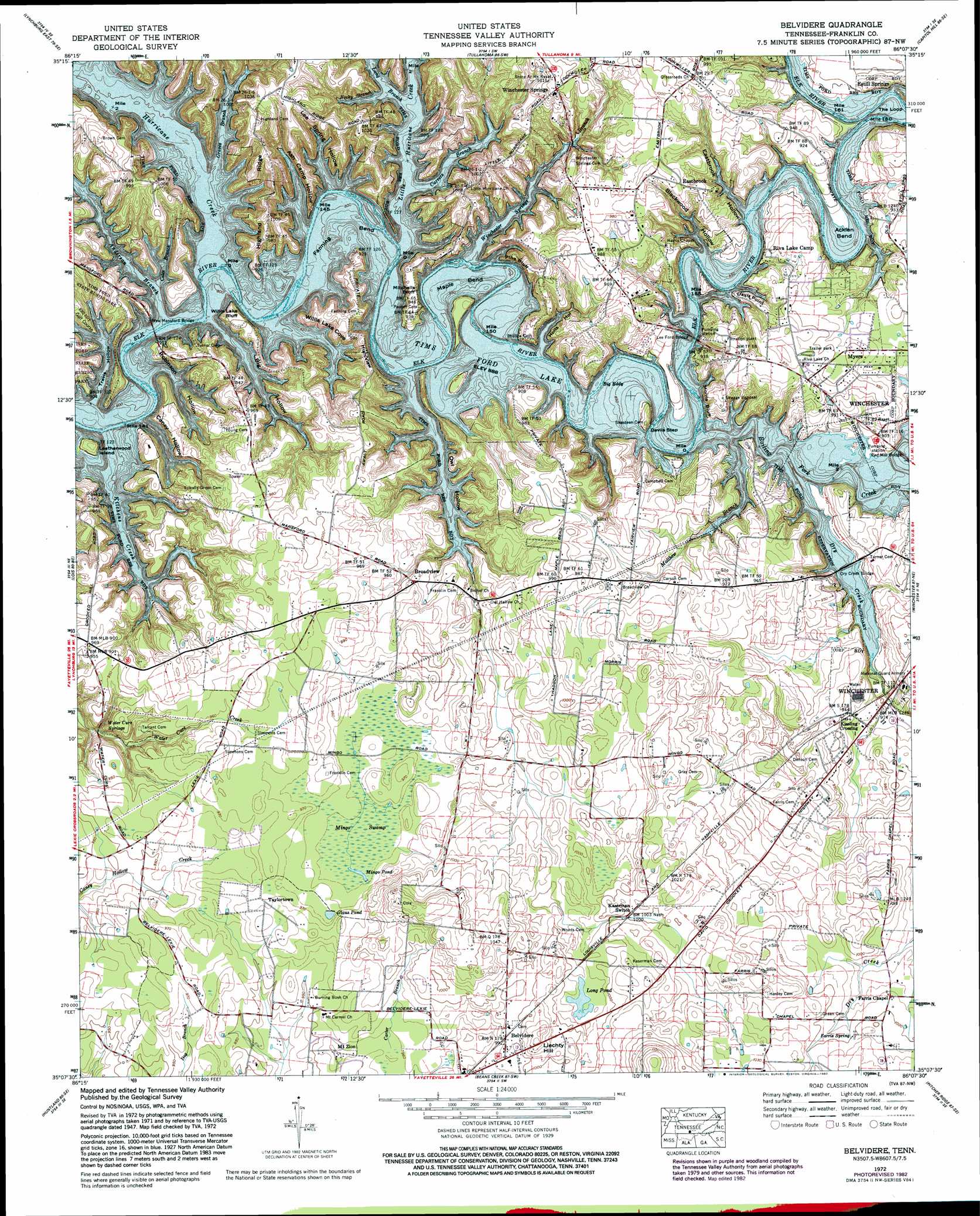
Belvidere Topo Map Tennessee
To zoom in, hover over the map of Belvidere
USGS Topo Quad 35086b2 - 1:24,000 scale
| Topo Map Name: | Belvidere |
| USGS Topo Quad ID: | 35086b2 |
| Print Size: | ca. 21 1/4" wide x 27" high |
| Southeast Coordinates: | 35.125° N latitude / 86.125° W longitude |
| Map Center Coordinates: | 35.1875° N latitude / 86.1875° W longitude |
| U.S. State: | TN |
| Filename: | o35086b2.jpg |
| Download Map JPG Image: | Belvidere topo map 1:24,000 scale |
| Map Type: | Topographic |
| Topo Series: | 7.5´ |
| Map Scale: | 1:24,000 |
| Source of Map Images: | United States Geological Survey (USGS) |
| Alternate Map Versions: |
Belvidere TN 1936 Download PDF Buy paper map Belvidere TN 1947, updated 1948 Download PDF Buy paper map Belvidere TN 1947, updated 1965 Download PDF Buy paper map Belvidere TN 1947, updated 1967 Download PDF Buy paper map Belvidere TN 1972, updated 1973 Download PDF Buy paper map Belvidere TN 1972, updated 1982 Download PDF Buy paper map Belvidere TN 2010 Download PDF Buy paper map Belvidere TN 2013 Download PDF Buy paper map Belvidere TN 2016 Download PDF Buy paper map |
1:24,000 Topo Quads surrounding Belvidere
Shelbyville |
Normandy |
Normandy Lake |
Manchester |
Hillsboro |
Lynchburg West |
Lynchburg East |
Tullahoma |
Capitol Hill |
Alto |
Mulberry |
Lois |
Belvidere |
Winchester |
Sewanee |
Flintville |
Huntland |
Beans Creek |
Pitcher Ridge |
Sinking Cove |
New Market |
King Cove |
Estill Fork |
Hytop |
Eureka |
> Back to 35086a1 at 1:100,000 scale
> Back to 35086a1 at 1:250,000 scale
> Back to U.S. Topo Maps home
Belvidere topo map: Gazetteer
Belvidere: Bends
Acklen Bend elevation 271m 889′Fanning Bend elevation 271m 889′
Maple Bend elevation 271m 889′
Shasteen Bend elevation 271m 889′
The Loop elevation 271m 889′
Belvidere: Bridges
Dry Creek Bridge elevation 271m 889′Lee Ford Bridge elevation 271m 889′
Lockmiller Bridge (historical) elevation 271m 889′
New Mansford Bridge elevation 271m 889′
Old Mansford Bridge (historical) elevation 271m 889′
Owl Hollow Bridge (historical) elevation 271m 889′
Red Mill Bridge elevation 271m 889′
Willis Lake Bridge (historical) elevation 271m 889′
Belvidere: Capes
Davis Point elevation 285m 935′Belvidere: Cliffs
Devils Step elevation 271m 889′High View elevation 271m 889′
Mitchells Bluff elevation 271m 889′
Morris Bluff elevation 271m 889′
Pine Bluff elevation 285m 935′
Belvidere: Crossings
Eastbrook Ford (historical) elevation 271m 889′Jones Ford (historical) elevation 271m 889′
Lees Ford (historical) elevation 271m 889′
Manns Ford (historical) elevation 271m 889′
Belvidere: Islands
Leatherwood Island elevation 282m 925′Belvidere: Lakes
Long Pond elevation 302m 990′Mingo Pond elevation 291m 954′
Belvidere: Parks
Tims Ford State Rustic Park elevation 276m 905′Winchester City Park elevation 273m 895′
Belvidere: Populated Places
Belvidere elevation 302m 990′Broadview elevation 294m 964′
Dripping Springs Subdivision elevation 286m 938′
Dry Creek Estates elevation 296m 971′
Eastbrook elevation 299m 980′
Kissling Crossing elevation 279m 915′
Mansford (historical) elevation 271m 889′
Murray Lake Estates elevation 285m 935′
Myers elevation 291m 954′
Taylortown elevation 296m 971′
Winchester Springs elevation 309m 1013′
Belvidere: Post Offices
Belvidere Post Office elevation 296m 971′Belvidere: Rapids
Big Eddy elevation 271m 889′Belvidere: Reservoirs
Glaus Pond elevation 294m 964′Murray Lake elevation 271m 889′
Belvidere: Ridges
Highland Ridge elevation 307m 1007′Belvidere: Springs
Farris Spring elevation 305m 1000′Lee Spring elevation 271m 889′
Shadow Spring elevation 271m 889′
Water Cure Springs elevation 275m 902′
Winchester Springs elevation 271m 889′
Belvidere: Streams
Anderson Branch elevation 271m 889′Bear Branch elevation 271m 889′
Boiling Fork Creek elevation 271m 889′
Carter Branch elevation 293m 961′
Carvers Branch elevation 271m 889′
Coles Branch elevation 271m 889′
Dry Creek elevation 271m 889′
Graves Branch elevation 271m 889′
Hessey Branch elevation 271m 889′
Hurricane Creek elevation 271m 889′
Kitchens Creek elevation 271m 889′
Little Hurricane Creek elevation 271m 889′
Long Branch elevation 271m 889′
Matthew Branch elevation 271m 889′
Owl Hollow Creek elevation 271m 889′
Push Creek elevation 307m 1007′
Rocky Branch elevation 271m 889′
Winchester Springs Branch elevation 271m 889′
Belvidere: Summits
Liechty Hill elevation 318m 1043′Belvidere: Swamps
Mingo Swamp elevation 291m 954′Belvidere: Valleys
Ash Camp Hollow elevation 271m 889′Big Hollow elevation 271m 889′
Blackwood Hollow elevation 271m 889′
Caney Hollow elevation 271m 889′
Eastbrook Hollow elevation 271m 889′
Holts Hollow elevation 271m 889′
Kitchen Hollow elevation 271m 889′
Lee Spring Hollow elevation 271m 889′
Owl Hollow elevation 271m 889′
Robinson Hollow elevation 271m 889′
Sleepy Hollow elevation 271m 889′
Travis Hollow elevation 271m 889′
Willis Lake Cove elevation 271m 889′
Belvidere digital topo map on disk
Buy this Belvidere topo map showing relief, roads, GPS coordinates and other geographical features, as a high-resolution digital map file on DVD: