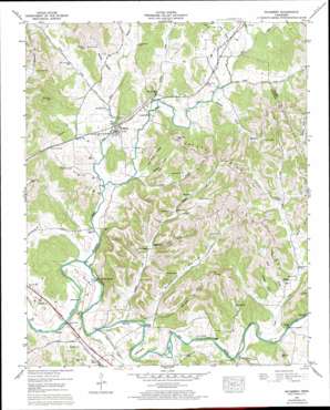
Mulberry Topo Map Tennessee
To zoom in, hover over the map of Mulberry
USGS Topo Quad 35086b4 - 1:24,000 scale
| Topo Map Name: | Mulberry |
| USGS Topo Quad ID: | 35086b4 |
| Print Size: | ca. 21 1/4" wide x 27" high |
| Southeast Coordinates: | 35.125° N latitude / 86.375° W longitude |
| Map Center Coordinates: | 35.1875° N latitude / 86.4375° W longitude |
| U.S. State: | TN |
| Filename: | o35086b4.jpg |
| Download Map JPG Image: | Mulberry topo map 1:24,000 scale |
| Map Type: | Topographic |
| Topo Series: | 7.5´ |
| Map Scale: | 1:24,000 |
| Source of Map Images: | United States Geological Survey (USGS) |
| Alternate Map Versions: |
Mulberry TN 1936 Download PDF Buy paper map Mulberry TN 1947, updated 1948 Download PDF Buy paper map Mulberry TN 1947, updated 1966 Download PDF Buy paper map Mulberry TN 1947, updated 1973 Download PDF Buy paper map Mulberry TN 2010 Download PDF Buy paper map Mulberry TN 2013 Download PDF Buy paper map Mulberry TN 2016 Download PDF Buy paper map |
1:24,000 Topo Quads surrounding Mulberry
> Back to 35086a1 at 1:100,000 scale
> Back to 35086a1 at 1:250,000 scale
> Back to U.S. Topo Maps home
Mulberry topo map: Gazetteer
Mulberry: Bends
Pitts Bend elevation 214m 702′The Quarter elevation 213m 698′
Mulberry: Bridges
Cowley Bridge elevation 205m 672′Dickey Bridge elevation 210m 688′
Mulberry Bridge elevation 204m 669′
Shiloh Bridge elevation 213m 698′
Mulberry: Islands
Dickey Island elevation 211m 692′Mulberry: Populated Places
Champ elevation 236m 774′Douglas elevation 224m 734′
Gattistown elevation 250m 820′
Kelso elevation 229m 751′
Lockes Mill elevation 216m 708′
Mulberry elevation 227m 744′
Mulberry: Post Offices
Kelso Post Office elevation 224m 734′Mulberry Post Office elevation 229m 751′
Mulberry: Ridges
Crystal Ridge elevation 320m 1049′Mulberry: Streams
Buckeye Creek elevation 219m 718′Buckeye Creek elevation 212m 695′
Cooper Branch elevation 210m 688′
Dukes Creek elevation 206m 675′
East Fork Mulberry Creek elevation 207m 679′
Eslick Branch elevation 218m 715′
Gattistown Branch elevation 222m 728′
Gimlet Creek elevation 213m 698′
Goose Branch elevation 229m 751′
Honey Branch elevation 230m 754′
Louse Creek elevation 223m 731′
Mulberry Creek elevation 207m 679′
Shelton Creek elevation 212m 695′
Stephens Creek elevation 207m 679′
Tucker Creek elevation 212m 695′
Wabash Creek elevation 213m 698′
West Fork Mulberry Creek elevation 207m 679′
Mulberry: Valleys
Dickey Hollow elevation 231m 757′Fanning Hollow elevation 220m 721′
Franklin Hollow elevation 212m 695′
John Moore Hollow elevation 216m 708′
McGee Hollow elevation 219m 718′
McNeece Hollow elevation 215m 705′
Moorhead Hollow elevation 212m 695′
Neal Hollow elevation 227m 744′
Taylor Hollow elevation 211m 692′
Mulberry digital topo map on disk
Buy this Mulberry topo map showing relief, roads, GPS coordinates and other geographical features, as a high-resolution digital map file on DVD:


