Fayetteville Topo Map Tennessee
To zoom in, hover over the map of Fayetteville
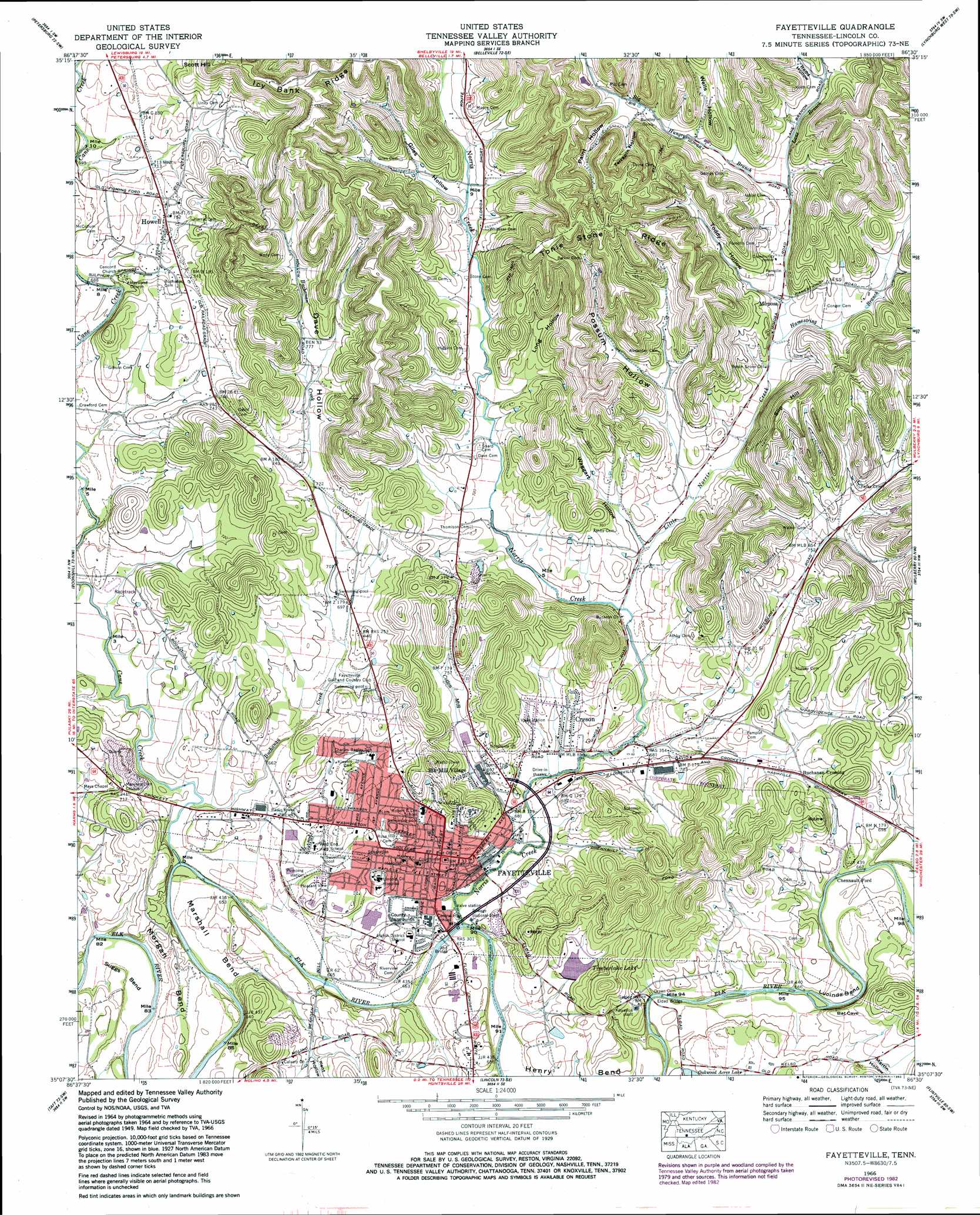
USGS Topo Quad 35086b5 - 1:24,000 scale
| Topo Map Name: | Fayetteville |
| USGS Topo Quad ID: | 35086b5 |
| Print Size: | ca. 21 1/4" wide x 27" high |
| Southeast Coordinates: | 35.125° N latitude / 86.5° W longitude |
| Map Center Coordinates: | 35.1875° N latitude / 86.5625° W longitude |
| U.S. State: | TN |
| Filename: | o35086b5.jpg |
| Download Map JPG Image: | Fayetteville topo map 1:24,000 scale |
| Map Type: | Topographic |
| Topo Series: | 7.5´ |
| Map Scale: | 1:24,000 |
| Source of Map Images: | United States Geological Survey (USGS) |
| Alternate Map Versions: |
Fayetteville TN 1936 Download PDF Buy paper map Fayetteville TN 1951 Download PDF Buy paper map Fayetteville TN 1966, updated 1969 Download PDF Buy paper map Fayetteville TN 1966, updated 1982 Download PDF Buy paper map Fayetteville TN 2010 Download PDF Buy paper map Fayetteville TN 2013 Download PDF Buy paper map Fayetteville TN 2016 Download PDF Buy paper map |
1:24,000 Topo Quads surrounding Fayetteville
Lewisburg |
Belfast |
Bedford |
Shelbyville |
Normandy |
Cornersville |
Petersburg |
Belleville |
Lynchburg West |
Lynchburg East |
Frankewing |
Boonshill |
Fayetteville |
Mulberry |
Lois |
Dellrose |
Taft |
Lincoln |
Flintville |
Huntland |
Ardmore |
Toney |
Fisk |
New Market |
King Cove |
> Back to 35086a1 at 1:100,000 scale
> Back to 35086a1 at 1:250,000 scale
> Back to U.S. Topo Maps home
Fayetteville topo map: Gazetteer
Fayetteville: Airports
Lady Jane Airport elevation 215m 705′Wilks Airport (historical) elevation 211m 692′
Fayetteville: Bends
Lucinda Bend elevation 208m 682′Marshall Bend elevation 201m 659′
Morgan Bend elevation 208m 682′
Suggs Bend elevation 204m 669′
Fayetteville: Bridges
Abd Bridge elevation 200m 656′Eldad Bridge elevation 199m 652′
Fayetteville: Crossings
Chennault Ford elevation 203m 666′Clarks Ferry (historical) elevation 201m 659′
Clarks Ford elevation 199m 652′
Roper Ferry (historical) elevation 201m 659′
Fayetteville: Dams
Rambo Lake Dam elevation 204m 669′Timber Lake Dam elevation 212m 695′
Fayetteville: Parks
Mulberry-Washington-Lincoln Historic District elevation 215m 705′South Elk Street Historic District elevation 207m 679′
Fayetteville: Populated Places
Creson elevation 219m 718′Elk Mill Village elevation 215m 705′
Elmwood Terrace elevation 220m 721′
Fayetteville elevation 215m 705′
Gethsemane (historical) elevation 229m 751′
Howell elevation 228m 748′
Madden Homes elevation 206m 675′
Mayberry Courts elevation 213m 698′
Mimosa elevation 225m 738′
Fayetteville: Post Offices
Fayetteville Post Office elevation 217m 711′Fayetteville: Reservoirs
Rambo Lake elevation 204m 669′Timber Lake elevation 212m 695′
Fayetteville: Ridges
Icy Bank Ridge elevation 342m 1122′Tonie Stone Ridge elevation 348m 1141′
Fayetteville: Streams
Big Hungry Branch elevation 231m 757′Buchanan Creek elevation 199m 652′
Cane Creek elevation 196m 643′
Cotton Mill Branch elevation 200m 656′
Hamestring Branch elevation 222m 728′
Hayes Branch elevation 201m 659′
Lane Branch elevation 232m 761′
Little Norris Creek elevation 208m 682′
Norris Creek elevation 200m 656′
Tanyard Branch elevation 200m 656′
Fayetteville: Summits
Scott Hill elevation 337m 1105′Slip Hill elevation 319m 1046′
Fayetteville: Valleys
Dave Hollow elevation 221m 725′Giles Hollow elevation 225m 738′
Hopper Hollow elevation 236m 774′
Kate Hollow elevation 244m 800′
Kent Hollow elevation 212m 695′
Long Hollow elevation 226m 741′
Martin Hollow elevation 224m 734′
Paint Hollow elevation 261m 856′
Pitt Hollow elevation 237m 777′
Possum Hollow elevation 229m 751′
Redd Hollow elevation 242m 793′
Terrapin Hollow elevation 266m 872′
Waggart Hollow elevation 211m 692′
Wells Hollow elevation 247m 810′
Fayetteville digital topo map on disk
Buy this Fayetteville topo map showing relief, roads, GPS coordinates and other geographical features, as a high-resolution digital map file on DVD: