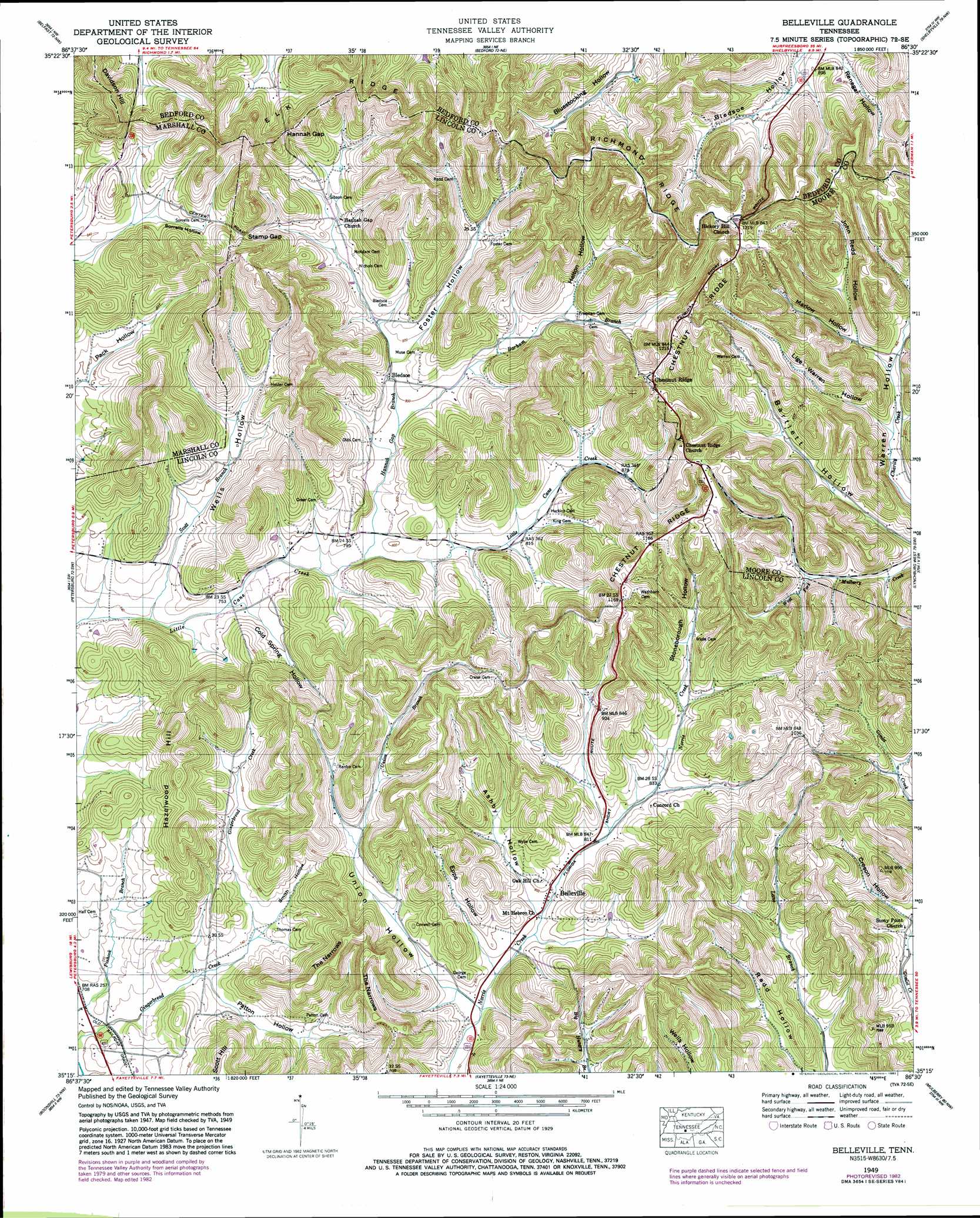
Belleville Topo Map Tennessee
To zoom in, hover over the map of Belleville
USGS Topo Quad 35086c5 - 1:24,000 scale
| Topo Map Name: | Belleville |
| USGS Topo Quad ID: | 35086c5 |
| Print Size: | ca. 21 1/4" wide x 27" high |
| Southeast Coordinates: | 35.25° N latitude / 86.5° W longitude |
| Map Center Coordinates: | 35.3125° N latitude / 86.5625° W longitude |
| U.S. State: | TN |
| Filename: | o35086c5.jpg |
| Download Map JPG Image: | Belleville topo map 1:24,000 scale |
| Map Type: | Topographic |
| Topo Series: | 7.5´ |
| Map Scale: | 1:24,000 |
| Source of Map Images: | United States Geological Survey (USGS) |
| Alternate Map Versions: |
Belleville TN 1936 Download PDF Buy paper map Belleville TN 1949, updated 1974 Download PDF Buy paper map Belleville TN 1949, updated 1982 Download PDF Buy paper map Belleville TN 1951 Download PDF Buy paper map Belleville TN 2010 Download PDF Buy paper map Belleville TN 2013 Download PDF Buy paper map Belleville TN 2016 Download PDF Buy paper map |
1:24,000 Topo Quads surrounding Belleville
Verona |
Farmington |
Unionville |
Deason |
Wartrace |
Lewisburg |
Belfast |
Bedford |
Shelbyville |
Normandy |
Cornersville |
Petersburg |
Belleville |
Lynchburg West |
Lynchburg East |
Frankewing |
Boonshill |
Fayetteville |
Mulberry |
Lois |
Dellrose |
Taft |
Lincoln |
Flintville |
Huntland |
> Back to 35086a1 at 1:100,000 scale
> Back to 35086a1 at 1:250,000 scale
> Back to U.S. Topo Maps home
Belleville topo map: Gazetteer
Belleville: Gaps
Hannah Gap elevation 331m 1085′Stamp Gap elevation 303m 994′
Belleville: Populated Places
Belleville elevation 240m 787′Bledsoe elevation 243m 797′
Chestnut Ridge elevation 348m 1141′
Belleville: Ridges
Chestnut Ridge elevation 357m 1171′Richmond Ridge elevation 384m 1259′
The Narrows elevation 343m 1125′
Belleville: Streams
Barham Branch elevation 240m 787′Hannah Gap Branch elevation 233m 764′
Scott Branch elevation 224m 734′
Union Branch elevation 231m 757′
Belleville: Summits
Davidson Hill elevation 363m 1190′Hazelwood Hill elevation 346m 1135′
Stamp Hill elevation 373m 1223′
Belleville: Valleys
Ashby Hollow elevation 241m 790′Bledsoe Hollow elevation 272m 892′
Cold Spring Hollow elevation 236m 774′
Creson Hollow elevation 249m 816′
Epps Hollow elevation 237m 777′
Helton Hollow elevation 265m 869′
John Redd Hollow elevation 278m 912′
Lige Warren Hollow elevation 265m 869′
Marlow Hollow elevation 278m 912′
Patton Hollow elevation 221m 725′
Renegar Hollow elevation 262m 859′
Smith Hollow elevation 228m 748′
Sorrells Hollow elevation 261m 856′
Stoneborough Hollow elevation 271m 889′
Union Hollow elevation 233m 764′
Wells Hollow elevation 229m 751′
Belleville digital topo map on disk
Buy this Belleville topo map showing relief, roads, GPS coordinates and other geographical features, as a high-resolution digital map file on DVD: