Normandy Lake Topo Map Tennessee
To zoom in, hover over the map of Normandy Lake
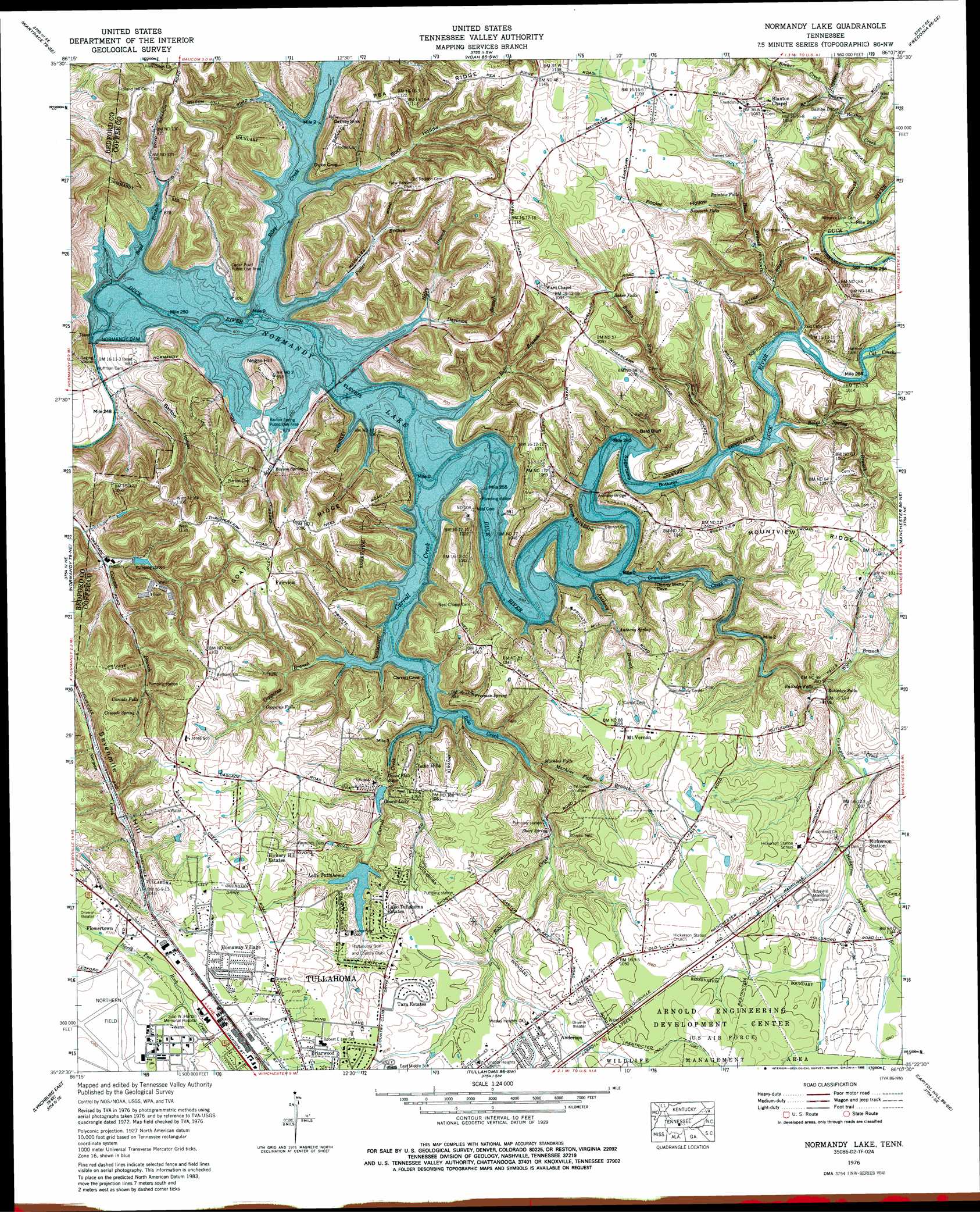
USGS Topo Quad 35086d2 - 1:24,000 scale
| Topo Map Name: | Normandy Lake |
| USGS Topo Quad ID: | 35086d2 |
| Print Size: | ca. 21 1/4" wide x 27" high |
| Southeast Coordinates: | 35.375° N latitude / 86.125° W longitude |
| Map Center Coordinates: | 35.4375° N latitude / 86.1875° W longitude |
| U.S. State: | TN |
| Filename: | o35086d2.jpg |
| Download Map JPG Image: | Normandy Lake topo map 1:24,000 scale |
| Map Type: | Topographic |
| Topo Series: | 7.5´ |
| Map Scale: | 1:24,000 |
| Source of Map Images: | United States Geological Survey (USGS) |
| Alternate Map Versions: |
Ovoca TN 1936 Download PDF Buy paper map Ovoca TN 1941, updated 1943 Download PDF Buy paper map Ovoca TN 1941, updated 1943 Download PDF Buy paper map Ovoca TN 1962, updated 1965 Download PDF Buy paper map Ovoca TN 1972, updated 1973 Download PDF Buy paper map Ovoca TN 1972, updated 1977 Download PDF Buy paper map Normandy Lake TN 1976, updated 1977 Download PDF Buy paper map Normandy Lake TN 1976, updated 1984 Download PDF Buy paper map Normandy Lake TN 1976, updated 1988 Download PDF Buy paper map Normandy Lake TN 1976, updated 1988 Download PDF Buy paper map Normandy Lake TN 2010 Download PDF Buy paper map Normandy Lake TN 2013 Download PDF Buy paper map Normandy Lake TN 2016 Download PDF Buy paper map |
1:24,000 Topo Quads surrounding Normandy Lake
Fosterville |
Webbs Jungle |
Beechgrove |
Hollow Springs |
Centertown |
Deason |
Wartrace |
Noah |
Fredonia |
Morrison |
Shelbyville |
Normandy |
Normandy Lake |
Manchester |
Hillsboro |
Lynchburg West |
Lynchburg East |
Tullahoma |
Capitol Hill |
Alto |
Mulberry |
Lois |
Belvidere |
Winchester |
Sewanee |
> Back to 35086a1 at 1:100,000 scale
> Back to 35086a1 at 1:250,000 scale
> Back to U.S. Topo Maps home
Normandy Lake topo map: Gazetteer
Normandy Lake: Airports
Parish Aerodrome Airport elevation 327m 1072′Tullahoma Regional Airport elevation 329m 1079′
Normandy Lake: Basins
Cathey Sink elevation 292m 958′Normandy Lake: Bends
Sugarcamp Bottoms elevation 267m 875′Normandy Lake: Bridges
Allen Bridge (historical) elevation 267m 875′Anthony Bridge elevation 267m 875′
Bashaw Bridge elevation 287m 941′
Denny Waite Bridge (historical) elevation 267m 875′
Hiles Bridge (historical) elevation 267m 875′
Huffman Bridge elevation 240m 787′
Normandy Lake: Cliffs
Bald Bluff elevation 275m 902′Normandy Lake: Crossings
Bashaw Ford elevation 285m 935′Beckman Ford (historical) elevation 267m 875′
Bluff Ford (historical) elevation 267m 875′
Dug Ford (historical) elevation 267m 875′
Lees Ford elevation 240m 787′
Neal Ford (historical) elevation 267m 875′
Old Millrace Ford (historical) elevation 267m 875′
Richardson Ford (historical) elevation 267m 875′
Sugarcamp Ford (historical) elevation 267m 875′
Waite Ford (historical) elevation 267m 875′
Normandy Lake: Dams
George Dickel Dam elevation 262m 859′Lake Tullahoma Dam elevation 306m 1003′
Normandy Dam elevation 267m 875′
Ovoca Lake Dam elevation 306m 1003′
Normandy Lake: Falls
Baker Falls elevation 304m 997′Bosworth Falls elevation 302m 990′
Cascade Falls elevation 301m 987′
Copperas Falls elevation 294m 964′
Machine Falls elevation 285m 935′
Ovoca Falls elevation 278m 912′
Rainbow Falls elevation 309m 1013′
Rutledge Falls elevation 280m 918′
Normandy Lake: Parks
Barton Spring Public Use Area elevation 269m 882′Cedar Point Public Use Area elevation 276m 905′
Normandy Lake: Populated Places
Anderson elevation 317m 1040′Bobs Cross Roads (historical) elevation 318m 1043′
Briarwood elevation 326m 1069′
Fairview elevation 332m 1089′
Flowertown elevation 330m 1082′
Hickory Hill Estates elevation 322m 1056′
Homaway Village elevation 332m 1089′
Lake Hills elevation 318m 1043′
Lake Tullahoma Estates elevation 320m 1049′
New Antwerp (historical) elevation 323m 1059′
Ovoca elevation 300m 984′
Riley Creek (historical) elevation 267m 875′
Rutledge Falls elevation 290m 951′
Sevenmile Hill elevation 300m 984′
Tara Estates elevation 325m 1066′
White Oak Trailer Park elevation 322m 1056′
Normandy Lake: Reservoirs
George Dickel Lake elevation 262m 859′Lake Tullahoma elevation 306m 1003′
Normandy Lake elevation 267m 875′
Ovoca Lake elevation 294m 964′
Normandy Lake: Ridges
Devils Backbone elevation 293m 961′Goat Ridge elevation 334m 1095′
Mountview Ridge elevation 327m 1072′
Normandy Lake: Springs
Anthony Spring elevation 288m 944′Barton Spring elevation 280m 918′
Blue Spring elevation 267m 875′
Cascade Spring elevation 302m 990′
Claude Carroll Spring elevation 267m 875′
Freeman Spring elevation 294m 964′
John Carroll Spring elevation 267m 875′
Martin Spring elevation 267m 875′
Old Cave Spring elevation 295m 967′
Short Spring elevation 287m 941′
Sugarcamp Spring elevation 283m 928′
Normandy Lake: Streams
Anthony Branch elevation 267m 875′Bates Spring Branch elevation 267m 875′
Bobo Creek elevation 267m 875′
Boyd Branch elevation 267m 875′
Brewer Creek elevation 288m 944′
Bullen Run elevation 267m 875′
Carroll Creek elevation 267m 875′
Cat Creek elevation 267m 875′
Copperas Branch elevation 267m 875′
Crumpton Creek elevation 267m 875′
Davidson Branch elevation 267m 875′
Eoff Branch elevation 267m 875′
Fuller Branch elevation 267m 875′
Haggard Branch elevation 289m 948′
Hale Branch elevation 267m 875′
Haley Branch elevation 267m 875′
Hickerson Spring Branch elevation 292m 958′
Machine Falls Branch elevation 268m 879′
Riley Creek elevation 267m 875′
Wiley Creek elevation 285m 935′
Normandy Lake: Summits
Negro Hill elevation 320m 1049′Sevenmile Hill elevation 338m 1108′
Normandy Lake: Valleys
Barton Hollow elevation 246m 807′Buck Hollow elevation 267m 875′
Carroll Hollow elevation 267m 875′
Cascade Hollow elevation 251m 823′
Poplar Hollow elevation 285m 935′
Normandy Lake digital topo map on disk
Buy this Normandy Lake topo map showing relief, roads, GPS coordinates and other geographical features, as a high-resolution digital map file on DVD: