Normandy Topo Map Tennessee
To zoom in, hover over the map of Normandy
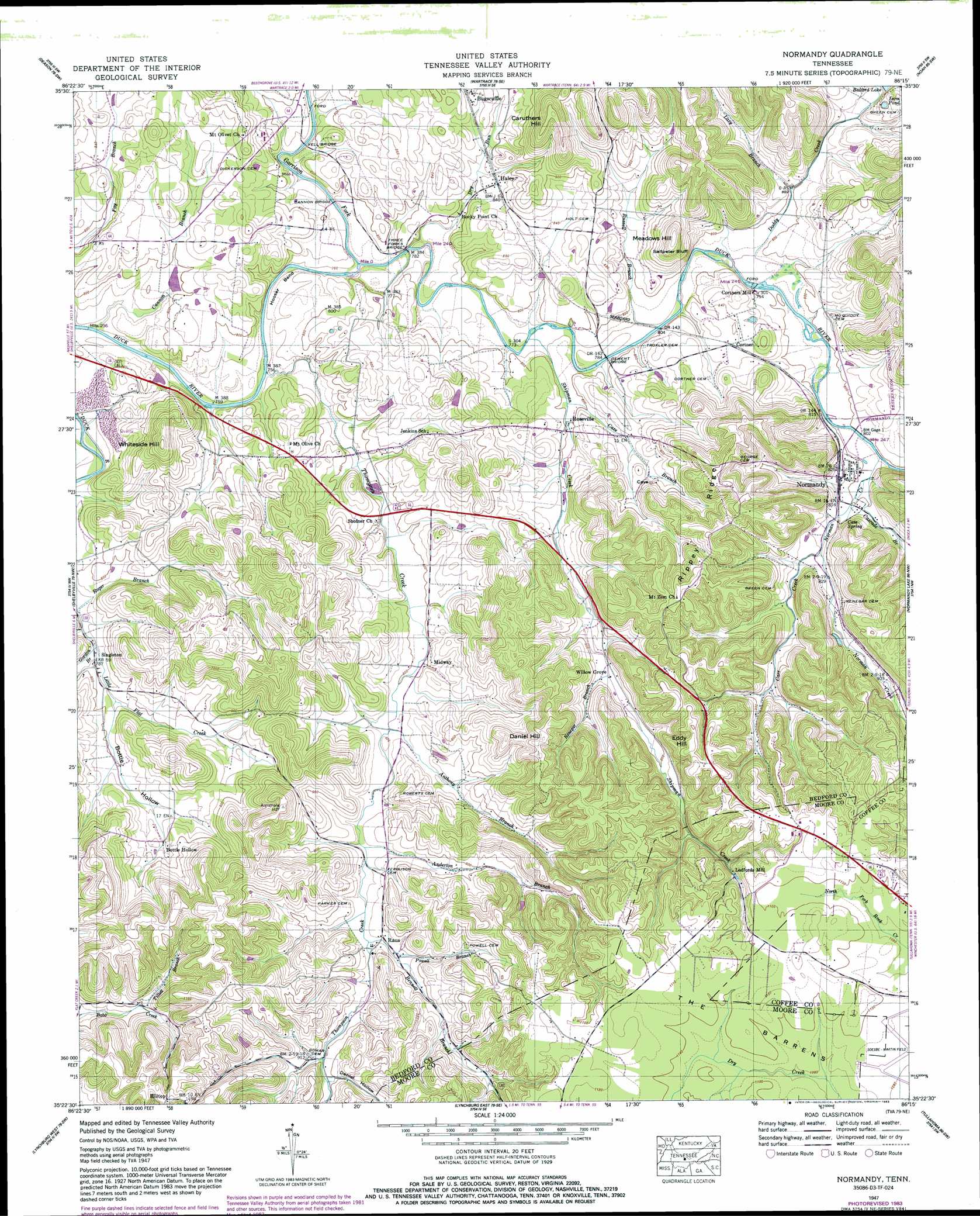
USGS Topo Quad 35086d3 - 1:24,000 scale
| Topo Map Name: | Normandy |
| USGS Topo Quad ID: | 35086d3 |
| Print Size: | ca. 21 1/4" wide x 27" high |
| Southeast Coordinates: | 35.375° N latitude / 86.25° W longitude |
| Map Center Coordinates: | 35.4375° N latitude / 86.3125° W longitude |
| U.S. State: | TN |
| Filename: | o35086d3.jpg |
| Download Map JPG Image: | Normandy topo map 1:24,000 scale |
| Map Type: | Topographic |
| Topo Series: | 7.5´ |
| Map Scale: | 1:24,000 |
| Source of Map Images: | United States Geological Survey (USGS) |
| Alternate Map Versions: |
Normandy TN 1936 Download PDF Buy paper map Normandy TN 1947, updated 1948 Download PDF Buy paper map Normandy TN 1947, updated 1948 Download PDF Buy paper map Normandy TN 1947, updated 1962 Download PDF Buy paper map Normandy TN 1947, updated 1971 Download PDF Buy paper map Normandy TN 1947, updated 1974 Download PDF Buy paper map Normandy TN 1947, updated 1983 Download PDF Buy paper map Normandy TN 1947, updated 1983 Download PDF Buy paper map Normandy TN 2010 Download PDF Buy paper map Normandy TN 2013 Download PDF Buy paper map Normandy TN 2016 Download PDF Buy paper map |
1:24,000 Topo Quads surrounding Normandy
Rover |
Fosterville |
Webbs Jungle |
Beechgrove |
Hollow Springs |
Unionville |
Deason |
Wartrace |
Noah |
Fredonia |
Bedford |
Shelbyville |
Normandy |
Normandy Lake |
Manchester |
Belleville |
Lynchburg West |
Lynchburg East |
Tullahoma |
Capitol Hill |
Fayetteville |
Mulberry |
Lois |
Belvidere |
Winchester |
> Back to 35086a1 at 1:100,000 scale
> Back to 35086a1 at 1:250,000 scale
> Back to U.S. Topo Maps home
Normandy topo map: Gazetteer
Normandy: Airports
Rutledge Field elevation 338m 1108′Normandy: Bends
Hooser Bend elevation 240m 787′Normandy: Bridges
Cannon Bridge elevation 236m 774′Dement Bridge elevation 236m 774′
Shofner Bridge elevation 225m 738′
Three Forks Bridge elevation 231m 757′
Yell Bridge elevation 229m 751′
Normandy: Cliffs
Saltpeter Bluff elevation 252m 826′Normandy: Dams
Bomar Lake Dam elevation 308m 1010′Cortner Lake Dam elevation 249m 816′
Normandy: Lakes
Isom Pond elevation 275m 902′Normandy: Parks
Normandy Historic District elevation 248m 813′Normandy: Populated Places
Bottle Hollow elevation 259m 849′Bugscuffle elevation 263m 862′
Cortner elevation 254m 833′
Cortners Mill elevation 239m 784′
Haley elevation 254m 833′
Ledfords Mill elevation 302m 990′
Midway elevation 243m 797′
Normandy elevation 253m 830′
Raus elevation 262m 859′
Roseville elevation 248m 813′
Singleton elevation 239m 784′
Willow Grove elevation 264m 866′
Normandy: Reservoirs
Bomar Lake elevation 308m 1010′Cortner Lake elevation 249m 816′
Normandy: Ridges
Rippey Ridge elevation 336m 1102′Normandy: Springs
Cave Spring elevation 251m 823′Normandy: Streams
Anderton Branch elevation 254m 833′Anthony Branch elevation 249m 816′
Bennett Branch elevation 258m 846′
Cannon Branch elevation 229m 751′
Carr Creek elevation 250m 820′
Cascade Branch elevation 243m 797′
Cave Branch elevation 241m 790′
Doddy Creek elevation 239m 784′
Dry Run elevation 230m 754′
Garrison Fork elevation 229m 751′
Gordon Branch elevation 231m 757′
Lazy Branch elevation 243m 797′
Norman Creek elevation 241m 790′
Powell Branch elevation 262m 859′
Renegar Branch elevation 265m 869′
Roger Branch elevation 228m 748′
Russell Branch elevation 237m 777′
Shipman Creek elevation 236m 774′
Thompson Creek elevation 230m 754′
Tillett Branch elevation 273m 895′
Normandy: Summits
Caruthers Hill elevation 339m 1112′Daniel Hill elevation 330m 1082′
Eddy Hill elevation 346m 1135′
Meadows Hill elevation 333m 1092′
Whiteside Hill elevation 340m 1115′
Normandy: Valleys
Bottle Hollow elevation 237m 777′Daniel Hollow elevation 273m 895′
Powell Hollow elevation 269m 882′
Normandy digital topo map on disk
Buy this Normandy topo map showing relief, roads, GPS coordinates and other geographical features, as a high-resolution digital map file on DVD: