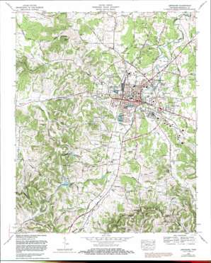
Lewisburg Topo Map Tennessee
To zoom in, hover over the map of Lewisburg
USGS Topo Quad 35086d7 - 1:24,000 scale
| Topo Map Name: | Lewisburg |
| USGS Topo Quad ID: | 35086d7 |
| Print Size: | ca. 21 1/4" wide x 27" high |
| Southeast Coordinates: | 35.375° N latitude / 86.75° W longitude |
| Map Center Coordinates: | 35.4375° N latitude / 86.8125° W longitude |
| U.S. State: | TN |
| Filename: | o35086d7.jpg |
| Download Map JPG Image: | Lewisburg topo map 1:24,000 scale |
| Map Type: | Topographic |
| Topo Series: | 7.5´ |
| Map Scale: | 1:24,000 |
| Source of Map Images: | United States Geological Survey (USGS) |
| Alternate Map Versions: |
Lewisburg TN 1936 Download PDF Buy paper map Lewisburg TN 1951 Download PDF Buy paper map Lewisburg TN 1966, updated 1969 Download PDF Buy paper map Lewisburg TN 1966, updated 1981 Download PDF Buy paper map Lewisburg TN 2010 Download PDF Buy paper map Lewisburg TN 2013 Download PDF Buy paper map Lewisburg TN 2016 Download PDF Buy paper map |
1:24,000 Topo Quads surrounding Lewisburg
> Back to 35086a1 at 1:100,000 scale
> Back to 35086a1 at 1:250,000 scale
> Back to U.S. Topo Maps home
Lewisburg topo map: Gazetteer
Lewisburg: Airports
Lewisburg Airport (historical) elevation 232m 761′Lewisburg: Crossings
Osborne Ford elevation 201m 659′Lewisburg: Dams
Lewisburg Reservoir Dam elevation 264m 866′Lewisburg: Gaps
Daugharty Gap elevation 351m 1151′McCollum Gap elevation 350m 1148′
Lewisburg: Parks
Jones Field elevation 225m 738′Lewisburg: Populated Places
Benton (historical) elevation 233m 764′Cochran elevation 229m 751′
Coleman Heights elevation 229m 751′
Duncanville elevation 242m 793′
Fairview elevation 231m 757′
Forest Hills elevation 249m 816′
Globe elevation 233m 764′
Hickory Heights elevation 238m 780′
Hillcrest elevation 237m 777′
Lewisburg elevation 225m 738′
Lincoln Park elevation 237m 777′
Marshall Heights elevation 250m 820′
Needmore elevation 224m 734′
Rolling Hills elevation 261m 856′
Wallace Acres elevation 220m 721′
White Acres elevation 247m 810′
Whitehead elevation 225m 738′
Wilson Hill elevation 243m 797′
Lewisburg: Post Offices
Lewisburg Post Office elevation 221m 725′Lewisburg: Reservoirs
Hil-A-Wa Lake elevation 257m 843′Lewisburg Reservoir elevation 264m 866′
Paradise Lake elevation 282m 925′
Lewisburg: Ridges
Baxter Ridge elevation 293m 961′Crawley Ridge elevation 332m 1089′
Elk Ridge elevation 309m 1013′
Persimmon Ridge elevation 353m 1158′
Lewisburg: Springs
Anderson Spring elevation 285m 935′Andrews Spring elevation 216m 708′
Barron Spring elevation 282m 925′
Hopkins Spring elevation 279m 915′
Murdock Spring elevation 302m 990′
Old Distillery Spring elevation 212m 695′
Old Marshall Academy Spring elevation 264m 866′
Ross Spring elevation 235m 770′
Vickrey Spring elevation 238m 780′
Lewisburg: Streams
Collins Creek elevation 217m 711′Copps Branch elevation 213m 698′
Doggett Branch elevation 224m 734′
Dry Branch elevation 202m 662′
Loyd Branch elevation 220m 721′
New Lake Branch elevation 231m 757′
Sanders Creek elevation 231m 757′
Snake Creek elevation 204m 669′
Thomas Branch elevation 229m 751′
Lewisburg: Summits
Barron Hill elevation 353m 1158′Davis Knob elevation 348m 1141′
Lewisburg: Valleys
Beck Hollow elevation 247m 810′Collins Hollow elevation 229m 751′
Houston Hollow elevation 232m 761′
Jackson Hollow elevation 238m 780′
McDaniel Hollow elevation 249m 816′
Rambo Hollow elevation 238m 780′
Wilson Hill Hollow elevation 239m 784′
Lewisburg digital topo map on disk
Buy this Lewisburg topo map showing relief, roads, GPS coordinates and other geographical features, as a high-resolution digital map file on DVD:


