Fredonia Topo Map Tennessee
To zoom in, hover over the map of Fredonia
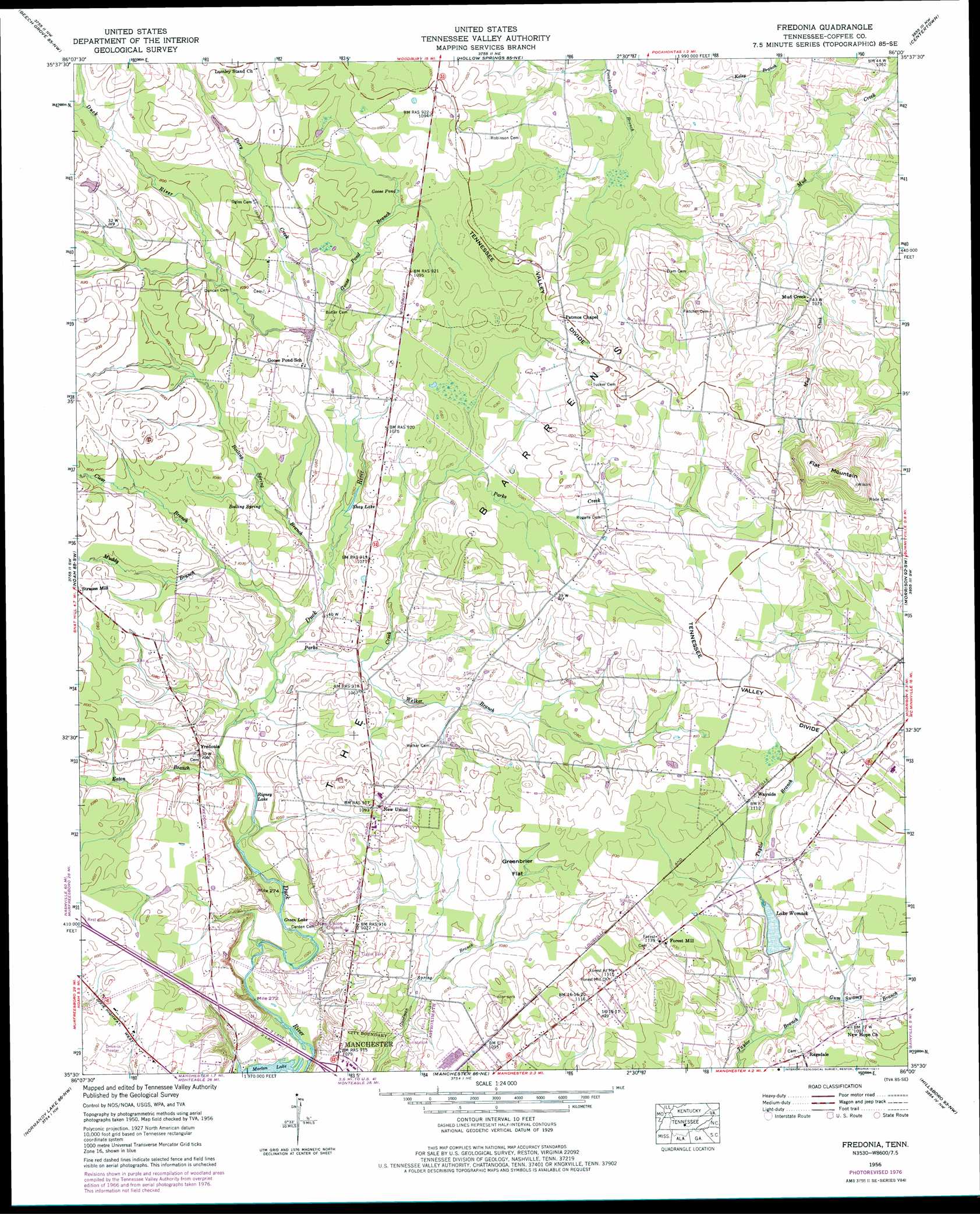
USGS Topo Quad 35086e1 - 1:24,000 scale
| Topo Map Name: | Fredonia |
| USGS Topo Quad ID: | 35086e1 |
| Print Size: | ca. 21 1/4" wide x 27" high |
| Southeast Coordinates: | 35.5° N latitude / 86° W longitude |
| Map Center Coordinates: | 35.5625° N latitude / 86.0625° W longitude |
| U.S. State: | TN |
| Filename: | o35086e1.jpg |
| Download Map JPG Image: | Fredonia topo map 1:24,000 scale |
| Map Type: | Topographic |
| Topo Series: | 7.5´ |
| Map Scale: | 1:24,000 |
| Source of Map Images: | United States Geological Survey (USGS) |
| Alternate Map Versions: |
Fredonia TN 1936 Download PDF Buy paper map Fredonia TN 1956, updated 1958 Download PDF Buy paper map Fredonia TN 1956, updated 1974 Download PDF Buy paper map Fredonia TN 1956, updated 1977 Download PDF Buy paper map Fredonia TN 1956, updated 1977 Download PDF Buy paper map Fredonia TN 2010 Download PDF Buy paper map Fredonia TN 2013 Download PDF Buy paper map Fredonia TN 2016 Download PDF Buy paper map |
1:24,000 Topo Quads surrounding Fredonia
Dillton |
Readyville |
Woodbury |
Short Mountain |
Dibrell |
Webbs Jungle |
Beechgrove |
Hollow Springs |
Centertown |
Mcminnville |
Wartrace |
Noah |
Fredonia |
Morrison |
Viola |
Normandy |
Normandy Lake |
Manchester |
Hillsboro |
Cane Hollow |
Lynchburg East |
Tullahoma |
Capitol Hill |
Alto |
Burrow Cove |
> Back to 35086e1 at 1:100,000 scale
> Back to 35086a1 at 1:250,000 scale
> Back to U.S. Topo Maps home
Fredonia topo map: Gazetteer
Fredonia: Dams
Lake Womac Dam elevation 327m 1072′Fredonia: Flats
Greenbrier Flat elevation 333m 1092′Fredonia: Lakes
Goose Pond elevation 329m 1079′Green Lake elevation 310m 1017′
Rigney Lake elevation 312m 1023′
Shay Lake elevation 320m 1049′
Fredonia: Populated Places
Brooksville (historical) elevation 332m 1089′Circle J Park elevation 329m 1079′
Forest Mill elevation 346m 1135′
Fredonia elevation 321m 1053′
Holly (historical) elevation 331m 1085′
Manchester Mobile Home Park elevation 325m 1066′
Mud Creek elevation 324m 1062′
New Union elevation 332m 1089′
Ragsdale elevation 332m 1089′
Strauss Mill elevation 334m 1095′
Teal (historical) elevation 320m 1049′
Fredonia: Reservoirs
Lake Womack elevation 327m 1072′Fredonia: Springs
Boiling Spring elevation 321m 1053′Fredonia: Streams
Boiling Spring Branch elevation 317m 1040′Clear Branch elevation 322m 1056′
Eaton Branch elevation 313m 1026′
Goose Pond Branch elevation 324m 1062′
Gum Swamp Branch elevation 322m 1056′
Muddy Branch elevation 316m 1036′
Parks Creek elevation 315m 1033′
Perry Creek elevation 325m 1066′
Welker Branch elevation 318m 1043′
Fredonia: Summits
Flat Mountain elevation 385m 1263′Fredonia: Swamps
Harfords Swamp elevation 336m 1102′Fredonia digital topo map on disk
Buy this Fredonia topo map showing relief, roads, GPS coordinates and other geographical features, as a high-resolution digital map file on DVD: