Deason Topo Map Tennessee
To zoom in, hover over the map of Deason
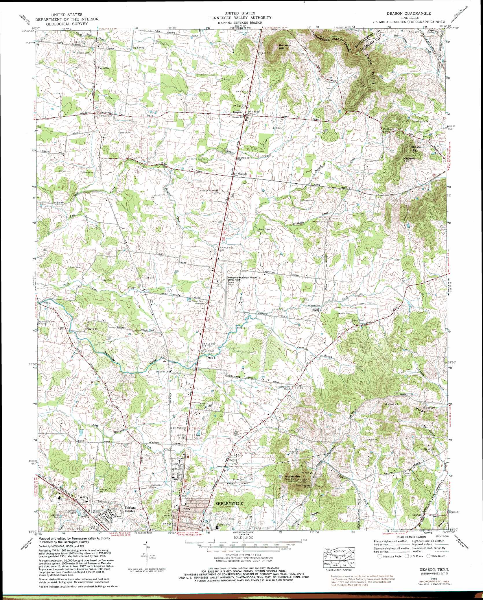
USGS Topo Quad 35086e4 - 1:24,000 scale
| Topo Map Name: | Deason |
| USGS Topo Quad ID: | 35086e4 |
| Print Size: | ca. 21 1/4" wide x 27" high |
| Southeast Coordinates: | 35.5° N latitude / 86.375° W longitude |
| Map Center Coordinates: | 35.5625° N latitude / 86.4375° W longitude |
| U.S. State: | TN |
| Filename: | o35086e4.jpg |
| Download Map JPG Image: | Deason topo map 1:24,000 scale |
| Map Type: | Topographic |
| Topo Series: | 7.5´ |
| Map Scale: | 1:24,000 |
| Source of Map Images: | United States Geological Survey (USGS) |
| Alternate Map Versions: |
Deason TN 1936 Download PDF Buy paper map Deason TN 1951 Download PDF Buy paper map Deason TN 1966, updated 1969 Download PDF Buy paper map Deason TN 1966, updated 1981 Download PDF Buy paper map Deason TN 2010 Download PDF Buy paper map Deason TN 2013 Download PDF Buy paper map Deason TN 2016 Download PDF Buy paper map |
1:24,000 Topo Quads surrounding Deason
College Grove |
Rockvale |
Murfreesboro |
Dillton |
Readyville |
Chapel Hill |
Rover |
Fosterville |
Webbs Jungle |
Beechgrove |
Farmington |
Unionville |
Deason |
Wartrace |
Noah |
Belfast |
Bedford |
Shelbyville |
Normandy |
Normandy Lake |
Petersburg |
Belleville |
Lynchburg West |
Lynchburg East |
Tullahoma |
> Back to 35086e1 at 1:100,000 scale
> Back to 35086a1 at 1:250,000 scale
> Back to U.S. Topo Maps home
Deason topo map: Gazetteer
Deason: Airports
Bomar Field-Shelbyville Municipal Airport elevation 242m 793′Deason: Populated Places
Caldwell elevation 253m 830′Deason elevation 247m 810′
Fairlane Estates elevation 247m 810′
Vannatta elevation 238m 780′
Deason: Reservoirs
Caperton Lake elevation 237m 777′Swings Lake elevation 240m 787′
Deason: Ridges
Pannell Ridge elevation 304m 997′Deason: Springs
Big Spring elevation 229m 751′Carrick Spring elevation 240m 787′
Hictons Big Spring elevation 229m 751′
Jones Spring elevation 278m 912′
Sulphur Spring elevation 225m 738′
Deason: Streams
Benford Creek elevation 227m 744′Coops Branch elevation 235m 770′
Hutton Creek elevation 236m 774′
Minkslide Creek elevation 237m 777′
Deason: Summits
Claxton Hill elevation 328m 1076′Epps Hills elevation 347m 1138′
Horse Mountain elevation 360m 1181′
Mingle Hill elevation 345m 1131′
Ransom Hill elevation 374m 1227′
Deason digital topo map on disk
Buy this Deason topo map showing relief, roads, GPS coordinates and other geographical features, as a high-resolution digital map file on DVD: