Verona Topo Map Tennessee
To zoom in, hover over the map of Verona
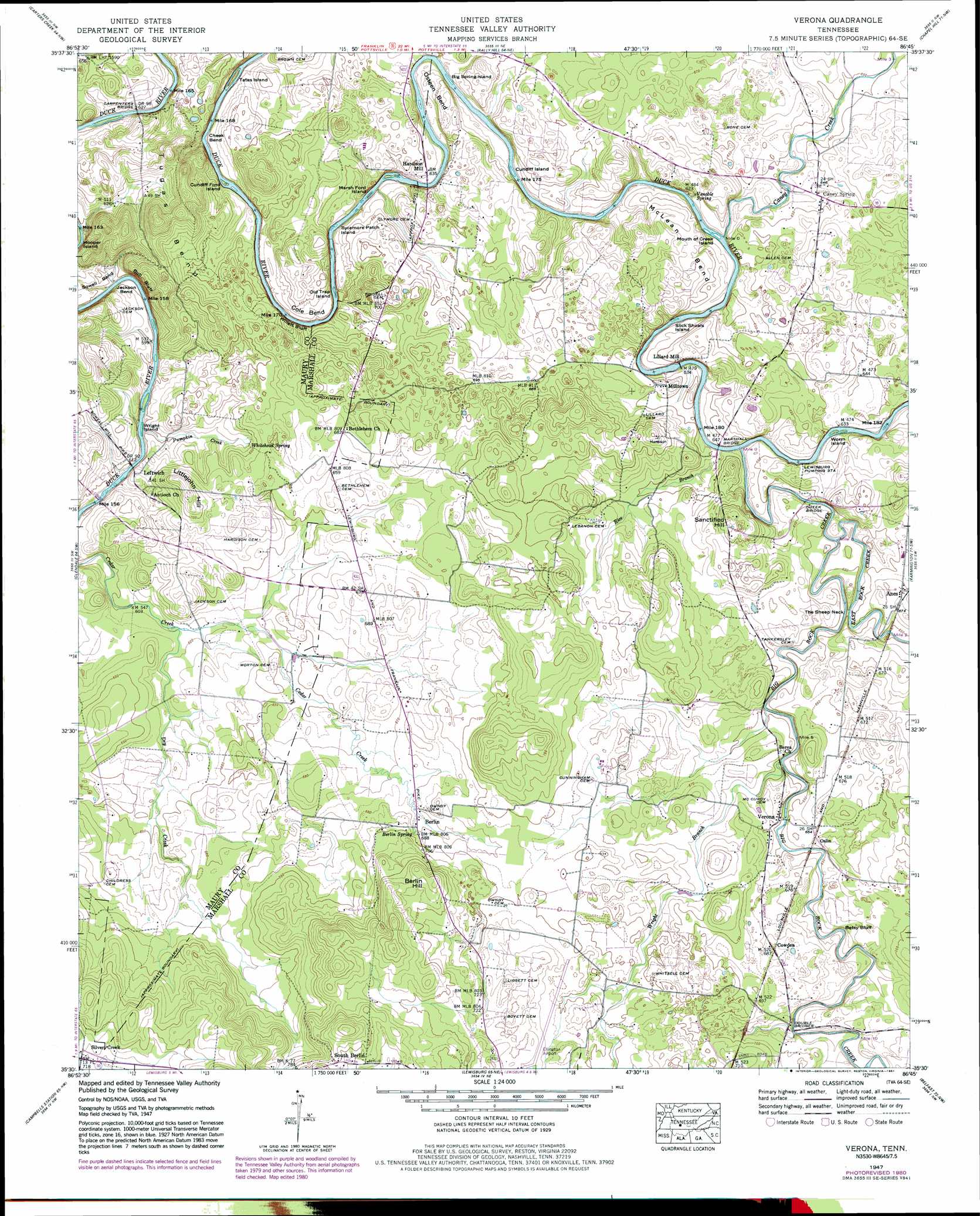
USGS Topo Quad 35086e7 - 1:24,000 scale
| Topo Map Name: | Verona |
| USGS Topo Quad ID: | 35086e7 |
| Print Size: | ca. 21 1/4" wide x 27" high |
| Southeast Coordinates: | 35.5° N latitude / 86.75° W longitude |
| Map Center Coordinates: | 35.5625° N latitude / 86.8125° W longitude |
| U.S. State: | TN |
| Filename: | o35086e7.jpg |
| Download Map JPG Image: | Verona topo map 1:24,000 scale |
| Map Type: | Topographic |
| Topo Series: | 7.5´ |
| Map Scale: | 1:24,000 |
| Source of Map Images: | United States Geological Survey (USGS) |
| Alternate Map Versions: |
Verona TN 1936 Download PDF Buy paper map Verona TN 1947, updated 1948 Download PDF Buy paper map Verona TN 1947, updated 1948 Download PDF Buy paper map Verona TN 1947, updated 1964 Download PDF Buy paper map Verona TN 1947, updated 1971 Download PDF Buy paper map Verona TN 1947, updated 1978 Download PDF Buy paper map Verona TN 1947, updated 1981 Download PDF Buy paper map Verona TN 2010 Download PDF Buy paper map Verona TN 2013 Download PDF Buy paper map Verona TN 2016 Download PDF Buy paper map |
1:24,000 Topo Quads surrounding Verona
Theta |
Spring Hill |
Bethesda |
College Grove |
Rockvale |
Godwin |
Carters Creek |
Rally Hill |
Chapel Hill |
Rover |
Columbia |
Glendale |
Verona |
Farmington |
Unionville |
Lynnville |
Campbells Station |
Lewisburg |
Belfast |
Bedford |
Milky Way |
Brick Church |
Cornersville |
Petersburg |
Belleville |
> Back to 35086e1 at 1:100,000 scale
> Back to 35086a1 at 1:250,000 scale
> Back to U.S. Topo Maps home
Verona topo map: Gazetteer
Verona: Airports
Ellington Airport elevation 215m 705′Verona: Bends
Cheek Bend elevation 181m 593′Cole Bend elevation 207m 679′
Jackson Bend elevation 190m 623′
Jones Bend elevation 236m 774′
McLean Bend elevation 211m 692′
Osteen Bend elevation 201m 659′
Verona: Bridges
Carpenters Bridge elevation 178m 583′Cheek Bridge elevation 186m 610′
Double Bridges elevation 198m 649′
Marshall Bridge elevation 186m 610′
Verona: Capes
The Sheep Neck elevation 200m 656′Verona: Cliffs
Betsy Bluff elevation 198m 649′Bull Bluff elevation 174m 570′
Willie Bluff elevation 196m 643′
Verona: Dams
Milltown Dam elevation 186m 610′Verona: Islands
Baptizing Island elevation 185m 606′Big Spring Island elevation 184m 603′
Cundiff Ford Island elevation 179m 587′
Cundiff Island elevation 190m 623′
Marsh Ford Island elevation 181m 593′
Mouth of Creek Island elevation 186m 610′
Old Trap Island elevation 178m 583′
Slick Shoals Island elevation 186m 610′
Sycamore Patch Island elevation 181m 593′
Tates Island elevation 180m 590′
Worm Island elevation 190m 623′
Wright Island elevation 174m 570′
Verona: Populated Places
Anes elevation 202m 662′Berlin elevation 207m 679′
Caney Spring elevation 196m 643′
Cowden elevation 209m 685′
Hardison Mill elevation 195m 639′
Leftwich elevation 194m 636′
Lillard Mill elevation 186m 610′
Milltown elevation 199m 652′
Oslin elevation 204m 669′
Silver Creek elevation 222m 728′
South Berlin elevation 242m 793′
Venable Spring elevation 190m 623′
Verona elevation 201m 659′
Verona: Springs
Berlin Spring elevation 209m 685′Caney Spring elevation 195m 639′
Whitehead Spring elevation 191m 626′
Verona: Streams
Big Rock Creek elevation 186m 610′Caney Creek elevation 185m 606′
Dry Creek elevation 186m 610′
East Rock Creek elevation 187m 613′
Pumpkin Creek elevation 174m 570′
Rice Branch elevation 189m 620′
Willet Branch elevation 183m 600′
Wright Branch elevation 193m 633′
Verona: Summits
Berlin Hill elevation 241m 790′Littlejohn Hill elevation 223m 731′
Sanctified Hill elevation 222m 728′
Verona digital topo map on disk
Buy this Verona topo map showing relief, roads, GPS coordinates and other geographical features, as a high-resolution digital map file on DVD: