Chapel Hill Topo Map Tennessee
To zoom in, hover over the map of Chapel Hill
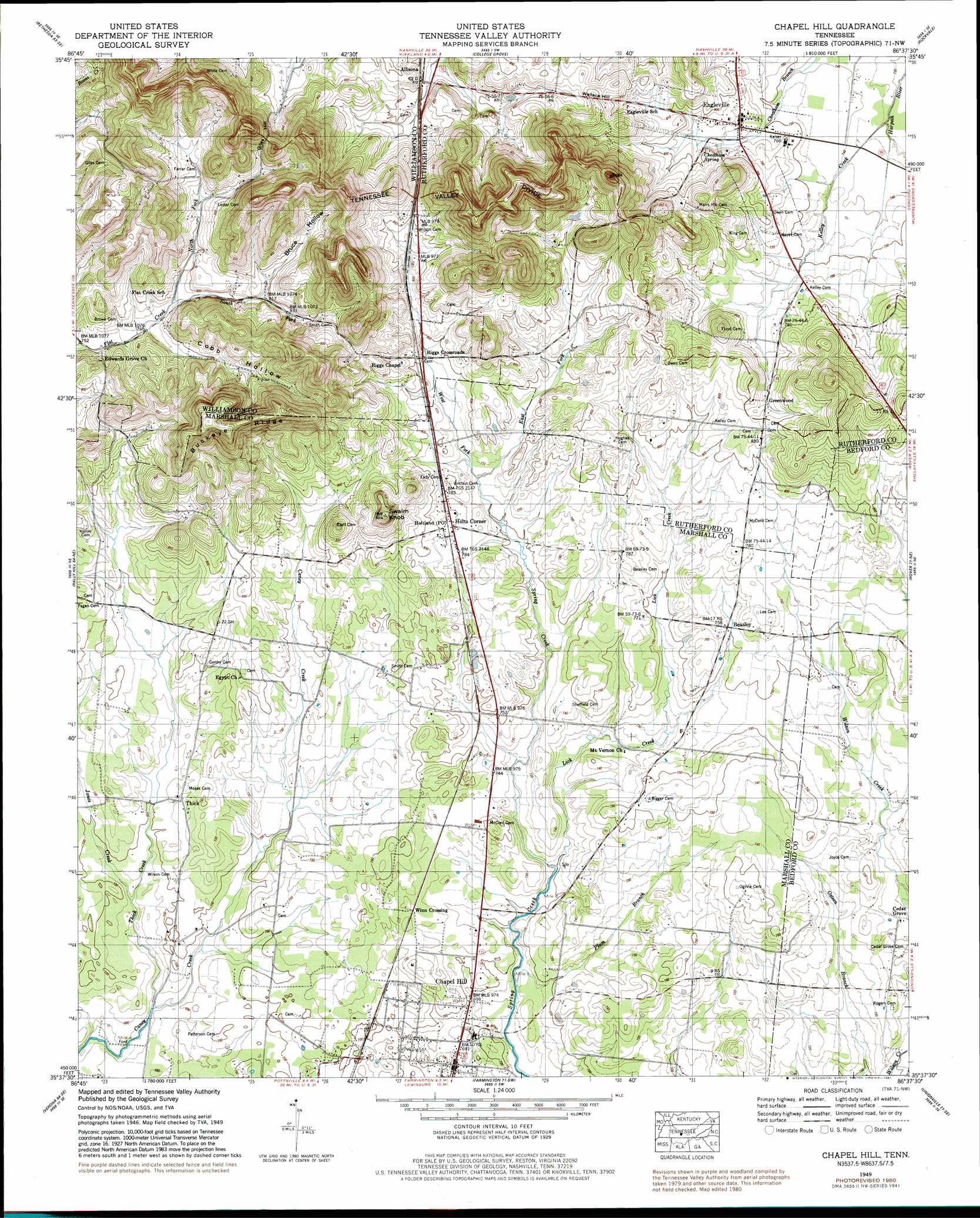
USGS Topo Quad 35086f6 - 1:24,000 scale
| Topo Map Name: | Chapel Hill |
| USGS Topo Quad ID: | 35086f6 |
| Print Size: | ca. 21 1/4" wide x 27" high |
| Southeast Coordinates: | 35.625° N latitude / 86.625° W longitude |
| Map Center Coordinates: | 35.6875° N latitude / 86.6875° W longitude |
| U.S. State: | TN |
| Filename: | o35086f6.jpg |
| Download Map JPG Image: | Chapel Hill topo map 1:24,000 scale |
| Map Type: | Topographic |
| Topo Series: | 7.5´ |
| Map Scale: | 1:24,000 |
| Source of Map Images: | United States Geological Survey (USGS) |
| Alternate Map Versions: |
Chapel Hill TN 1936 Download PDF Buy paper map Chapel Hill TN 1949, updated 1966 Download PDF Buy paper map Chapel Hill TN 1949, updated 1981 Download PDF Buy paper map Chapel Hill TN 1951 Download PDF Buy paper map Chapel Hill TN 2010 Download PDF Buy paper map Chapel Hill TN 2013 Download PDF Buy paper map Chapel Hill TN 2016 Download PDF Buy paper map |
1:24,000 Topo Quads surrounding Chapel Hill
Leipers Fork |
Franklin |
Nolensville |
Smyrna |
Walterhill |
Spring Hill |
Bethesda |
College Grove |
Rockvale |
Murfreesboro |
Carters Creek |
Rally Hill |
Chapel Hill |
Rover |
Fosterville |
Glendale |
Verona |
Farmington |
Unionville |
Deason |
Campbells Station |
Lewisburg |
Belfast |
Bedford |
Shelbyville |
> Back to 35086e1 at 1:100,000 scale
> Back to 35086a1 at 1:250,000 scale
> Back to U.S. Topo Maps home
Chapel Hill topo map: Gazetteer
Chapel Hill: Populated Places
Beasley elevation 230m 754′Cedar Grove elevation 219m 718′
Chapel Hill elevation 211m 692′
Eagleville elevation 235m 770′
Greenwood elevation 247m 810′
Holtland elevation 240m 787′
Holts Corner elevation 238m 780′
Riggs Crossroads elevation 242m 793′
Thick elevation 219m 718′
Chapel Hill: Ridges
Buckeye Ridge elevation 339m 1112′Chapel Hill: Springs
Cheatham Spring elevation 239m 784′Chapel Hill: Streams
East Fork Spring Creek elevation 231m 757′Jones Creek elevation 206m 675′
Kelley Creek elevation 221m 725′
Lick Creek elevation 213m 698′
North Fork Flat Creek elevation 235m 770′
Plum Branch elevation 209m 685′
South Fork Flat Creek elevation 235m 770′
Thick Creek elevation 201m 659′
West Fork Spring Creek elevation 231m 757′
Chapel Hill: Summits
Buckeye Knob elevation 354m 1161′Giles Hill elevation 292m 958′
Swaim Knob elevation 309m 1013′
Wallace Hill elevation 279m 915′
Chapel Hill: Valleys
Bruce Hollow elevation 248m 813′Cobb Hollow elevation 235m 770′
Chapel Hill digital topo map on disk
Buy this Chapel Hill topo map showing relief, roads, GPS coordinates and other geographical features, as a high-resolution digital map file on DVD: