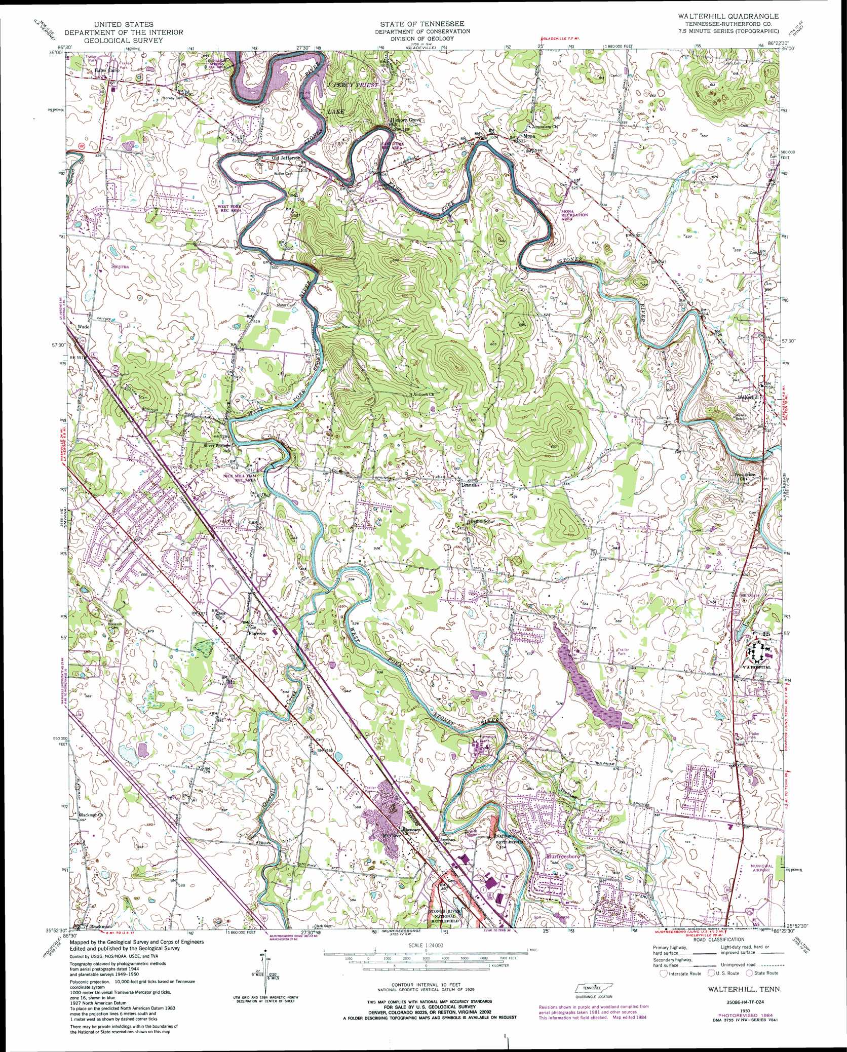
Walterhill Topo Map Tennessee
To zoom in, hover over the map of Walterhill
USGS Topo Quad 35086h4 - 1:24,000 scale
| Topo Map Name: | Walterhill |
| USGS Topo Quad ID: | 35086h4 |
| Print Size: | ca. 21 1/4" wide x 27" high |
| Southeast Coordinates: | 35.875° N latitude / 86.375° W longitude |
| Map Center Coordinates: | 35.9375° N latitude / 86.4375° W longitude |
| U.S. State: | TN |
| Filename: | o35086h4.jpg |
| Download Map JPG Image: | Walterhill topo map 1:24,000 scale |
| Map Type: | Topographic |
| Topo Series: | 7.5´ |
| Map Scale: | 1:24,000 |
| Source of Map Images: | United States Geological Survey (USGS) |
| Alternate Map Versions: |
Walterhill TN 1950 Download PDF Buy paper map Walterhill TN 1950, updated 1966 Download PDF Buy paper map Walterhill TN 1950, updated 1972 Download PDF Buy paper map Walterhill TN 1950, updated 1977 Download PDF Buy paper map Walterhill TN 1950, updated 1984 Download PDF Buy paper map Walterhill TN 1998, updated 1999 Download PDF Buy paper map Walterhill TN 2010 Download PDF Buy paper map Walterhill TN 2013 Download PDF Buy paper map Walterhill TN 2016 Download PDF Buy paper map |
1:24,000 Topo Quads surrounding Walterhill
Nashville East |
Hermitage |
Martha |
Lebanon |
Shop Springs |
Antioch |
La Vergne |
Gladeville |
Vine |
Watertown |
Nolensville |
Smyrna |
Walterhill |
Lascassas |
Milton |
College Grove |
Rockvale |
Murfreesboro |
Dillton |
Readyville |
Chapel Hill |
Rover |
Fosterville |
Webbs Jungle |
Beechgrove |
> Back to 35086e1 at 1:100,000 scale
> Back to 35086a1 at 1:250,000 scale
> Back to U.S. Topo Maps home
Walterhill topo map: Gazetteer
Walterhill: Airports
Murfreesboro Municipal Airport elevation 187m 613′Walterhill: Crossings
McFaddens Ford elevation 160m 524′Walterhill: Parks
East Fork Recreation Area elevation 151m 495′Mono Recreation Area elevation 158m 518′
Nice Mill Dam Recreation Area elevation 155m 508′
Stones River National Battlefield elevation 171m 561′
West Fork Recreation Area elevation 153m 501′
Walterhill: Populated Places
Asbury Prk elevation 174m 570′BAttlefield Meadows elevation 173m 567′
Bethel elevation 168m 551′
Blackman elevation 183m 600′
Blansett Meadows elevation 171m 561′
Cherry Hill Estates elevation 167m 547′
Cherry Lane Acres elevation 170m 557′
Colonial Village elevation 159m 521′
Confederate Glen Estates elevation 175m 574′
Cooks Corner elevation 177m 580′
Creekmont elevation 170m 557′
Fairmont elevation 176m 577′
Florence elevation 167m 547′
Georgetown elevation 174m 570′
Hales Camp elevation 159m 521′
Halewood Hills elevation 164m 538′
Haynes Haven elevation 183m 600′
Henry Lane elevation 177m 580′
Hickory Grove elevation 155m 508′
Hillwood Estates elevation 166m 544′
Hooper Acres elevation 174m 570′
Indian Springs elevation 175m 574′
Jamestown elevation 173m 567′
Joneswood elevation 162m 531′
Joywood elevation 178m 583′
Juniper Acres elevation 165m 541′
Key Estates elevation 177m 580′
Kings Estates elevation 174m 570′
Lake Farm Estates elevation 158m 518′
Lamb elevation 177m 580′
Leanna elevation 168m 551′
Little Ranch Acres elevation 175m 574′
Miller Estates elevation 174m 570′
Mona elevation 162m 531′
Mount Olive elevation 169m 554′
Nestledown Estates elevation 174m 570′
Northpointe Hall elevation 182m 597′
Palmer Heights elevation 184m 603′
Pioneer Estates elevation 171m 561′
Ravenwood elevation 183m 600′
Regency Park elevation 185m 606′
Reynolds elevation 170m 557′
Ridgefield elevation 177m 580′
Riverbend elevation 178m 583′
Riverview elevation 181m 593′
Rowland Estates elevation 175m 574′
Royal Court elevation 179m 587′
Sawyer Subdivision elevation 180m 590′
Sunnyside elevation 172m 564′
Timberlake elevation 170m 557′
Wade elevation 169m 554′
Walter Hill Estates elevation 165m 541′
Walterhill elevation 166m 544′
White Haven elevation 170m 557′
Williamsburg elevation 170m 557′
Yorktown elevation 168m 551′
Young Subdivision elevation 157m 515′
Walterhill: Springs
Sulphur Spring elevation 171m 561′Walterhill: Streams
East Fork Stones River elevation 144m 472′Overall Creek elevation 154m 505′
Sinking Creek elevation 161m 528′
West Fork Stones River elevation 144m 472′
Walterhill digital topo map on disk
Buy this Walterhill topo map showing relief, roads, GPS coordinates and other geographical features, as a high-resolution digital map file on DVD: