Nolensville Topo Map Tennessee
To zoom in, hover over the map of Nolensville
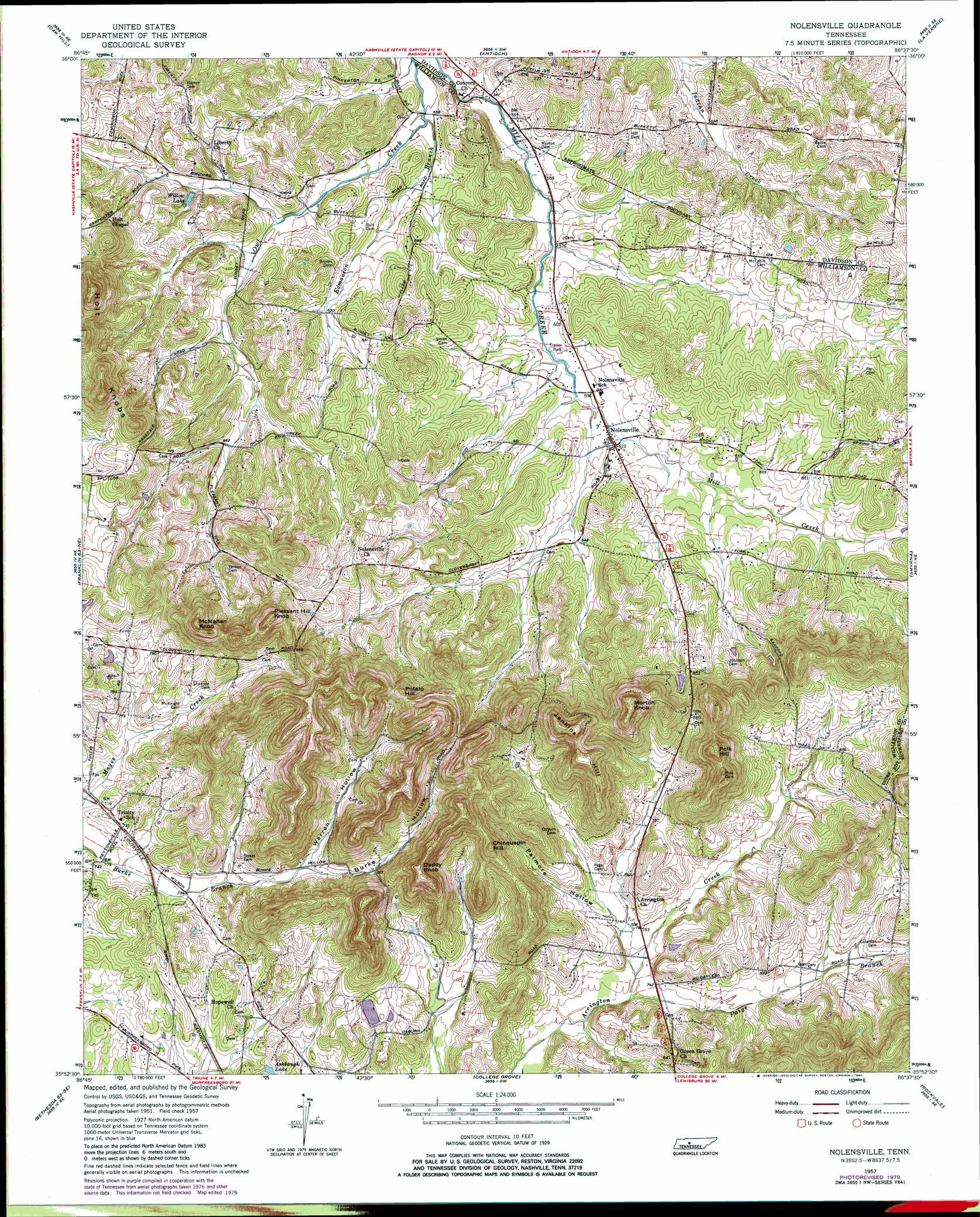
USGS Topo Quad 35086h6 - 1:24,000 scale
| Topo Map Name: | Nolensville |
| USGS Topo Quad ID: | 35086h6 |
| Print Size: | ca. 21 1/4" wide x 27" high |
| Southeast Coordinates: | 35.875° N latitude / 86.625° W longitude |
| Map Center Coordinates: | 35.9375° N latitude / 86.6875° W longitude |
| U.S. State: | TN |
| Filename: | o35086h6.jpg |
| Download Map JPG Image: | Nolensville topo map 1:24,000 scale |
| Map Type: | Topographic |
| Topo Series: | 7.5´ |
| Map Scale: | 1:24,000 |
| Source of Map Images: | United States Geological Survey (USGS) |
| Alternate Map Versions: |
Nolensville TN 1957, updated 1958 Download PDF Buy paper map Nolensville TN 1957, updated 1972 Download PDF Buy paper map Nolensville TN 1957, updated 1980 Download PDF Buy paper map Nolensville TN 1957, updated 1991 Download PDF Buy paper map Nolensville TN 2010 Download PDF Buy paper map Nolensville TN 2013 Download PDF Buy paper map Nolensville TN 2016 Download PDF Buy paper map |
1:24,000 Topo Quads surrounding Nolensville
Scottsboro |
Nashville West |
Nashville East |
Hermitage |
Martha |
Bellevue |
Oak Hill |
Antioch |
La Vergne |
Gladeville |
Leipers Fork |
Franklin |
Nolensville |
Smyrna |
Walterhill |
Spring Hill |
Bethesda |
College Grove |
Rockvale |
Murfreesboro |
Carters Creek |
Rally Hill |
Chapel Hill |
Rover |
Fosterville |
> Back to 35086e1 at 1:100,000 scale
> Back to 35086a1 at 1:250,000 scale
> Back to U.S. Topo Maps home
Nolensville topo map: Gazetteer
Nolensville: Dams
Lake Colonial Estates Dam elevation 238m 780′Nolensville: Lakes
Ashbaugh Lake elevation 233m 764′Nolensville: Mines
Holt Mine elevation 222m 728′Redmon Quarry elevation 200m 656′
Nolensville: Populated Places
Concord Forest elevation 199m 652′Hickory Hills elevation 222m 728′
Hooker Hills elevation 258m 846′
Lake Colonial Estates elevation 240m 787′
Nolensville elevation 190m 623′
Owl Creek elevation 174m 570′
Stonebrook elevation 187m 613′
Sunset Acres elevation 212m 695′
Nolensville: Post Offices
Nolensville Post Office elevation 185m 606′Nolensville: Reservoirs
Lake Colonial Estates elevation 238m 780′Willow Lake elevation 192m 629′
Nolensville: Ridges
Holt Knobs elevation 268m 879′Nolensville: Streams
Edmondson Branch elevation 168m 551′Paige Branch elevation 222m 728′
Nolensville: Summits
Chinquapin Hill elevation 330m 1082′Daddy Knob elevation 353m 1158′
Jenkins Hill elevation 367m 1204′
McMahan Knob elevation 355m 1164′
Morton Knob elevation 365m 1197′
Pleasant Hill Knob elevation 361m 1184′
Polk Hill elevation 366m 1200′
Potato Hill elevation 326m 1069′
Nolensville: Valleys
Burke Hollow elevation 239m 784′Molly Hollow elevation 229m 751′
Palmore Hollow elevation 225m 738′
Warren Hollow elevation 238m 780′
Nolensville digital topo map on disk
Buy this Nolensville topo map showing relief, roads, GPS coordinates and other geographical features, as a high-resolution digital map file on DVD: