Negro Hollow Topo Map Tennessee
To zoom in, hover over the map of Negro Hollow
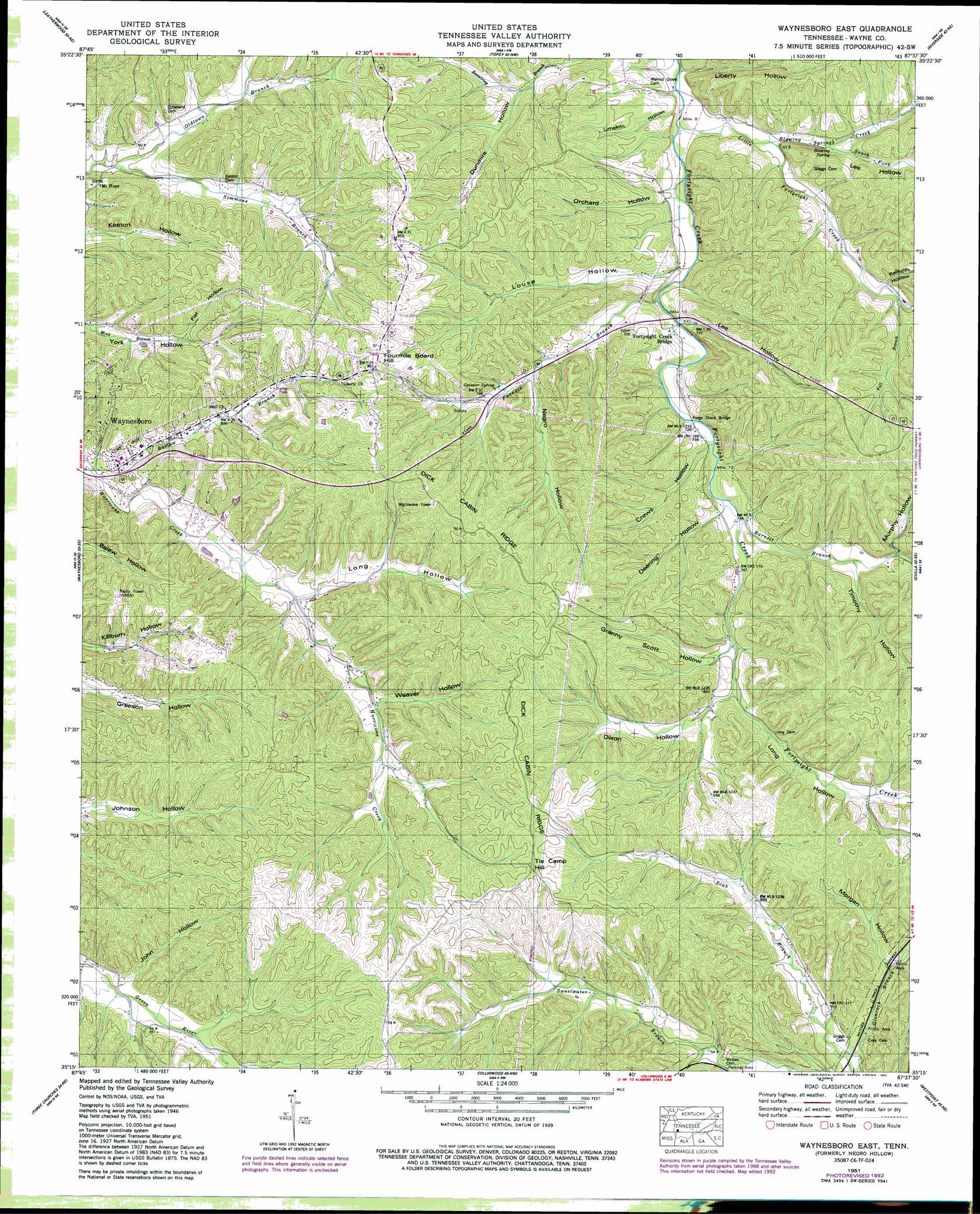
USGS Topo Quad 35087c6 - 1:24,000 scale
| Topo Map Name: | Negro Hollow |
| USGS Topo Quad ID: | 35087c6 |
| Print Size: | ca. 21 1/4" wide x 27" high |
| Southeast Coordinates: | 35.25° N latitude / 87.625° W longitude |
| Map Center Coordinates: | 35.3125° N latitude / 87.6875° W longitude |
| U.S. State: | TN |
| Filename: | o35087c6.jpg |
| Download Map JPG Image: | Negro Hollow topo map 1:24,000 scale |
| Map Type: | Topographic |
| Topo Series: | 7.5´ |
| Map Scale: | 1:24,000 |
| Source of Map Images: | United States Geological Survey (USGS) |
| Alternate Map Versions: |
Negro Hollow TN 1936 Download PDF Buy paper map Negro Hollow TN 1951, updated 1954 Download PDF Buy paper map Negro Hollow TN 1951, updated 1977 Download PDF Buy paper map Waynesboro East TN 1951, updated 1992 Download PDF Buy paper map Waynesboro East TN 2010 Download PDF Buy paper map Waynesboro East TN 2013 Download PDF Buy paper map Waynesboro East TN 2016 Download PDF Buy paper map |
1:24,000 Topo Quads surrounding Negro Hollow
Pope |
Linden |
Graves Spring |
Kimmins |
Gordonsburg |
Clifton |
Leatherwood |
Topsy |
Riverside |
Henryville |
Eagle Creek |
Waynesboro |
Negro Hollow |
Ovilla |
Deerfield |
Martins Mills |
Three Churches |
Collinwood |
Westpoint |
Long Branch |
Ransom Stand |
Cypress Inn |
Whitten |
Saint Joseph |
Loretto |
> Back to 35087a1 at 1:100,000 scale
> Back to 35086a1 at 1:250,000 scale
> Back to U.S. Topo Maps home
Negro Hollow topo map: Gazetteer
Negro Hollow: Bridges
Forge Stack Bridge elevation 220m 721′Negro Hollow: Mines
Broach Mine elevation 262m 859′Buchanan Prospects elevation 293m 961′
Churchwell Prospects elevation 289m 948′
Crews Mine elevation 268m 879′
East Furnace Ridge Mine elevation 269m 882′
Foster Hollow Prospect elevation 268m 879′
Irontop Mine elevation 257m 843′
Keaton Springs Mine elevation 265m 869′
Lee Hollow Mines elevation 294m 964′
Lee Ridge Mines elevation 275m 902′
Murphy Mine elevation 252m 826′
Negro Ridge Mine elevation 268m 879′
Nutt Prospect elevation 260m 853′
Perigo Mine elevation 280m 918′
Robinette Prospect elevation 288m 944′
Sapling Mine elevation 261m 856′
West Furnace Ridge Mine elevation 249m 816′
West Mine elevation 287m 941′
Negro Hollow: Populated Places
Mount Hope elevation 230m 754′Valleyview Subdivision elevation 232m 761′
Negro Hollow: Ridges
Dick Cabin Ridge elevation 300m 984′East Furnace Ridge elevation 279m 915′
Lee Ridge elevation 279m 915′
Negro Ridge elevation 283m 928′
West Furnace Ridge elevation 264m 866′
Negro Hollow: Springs
Blowing Spring elevation 217m 711′Geissler Spring elevation 253m 830′
Negro Hollow: Streams
Barlow Branch elevation 218m 715′Barnett Branch elevation 225m 738′
Blowing Springs Creek elevation 211m 692′
Fall Branch elevation 230m 754′
Furnace Branch elevation 212m 695′
Little Fortyeight Creek elevation 206m 675′
Long Hollow Branch elevation 237m 777′
Louse Hollow Branch elevation 212m 695′
Oldtown Branch elevation 210m 688′
South Fork Blowing Springs Creek elevation 219m 718′
Stoeball Branch elevation 238m 780′
Sweetwater Branch elevation 226m 741′
West Fork Fortyeight Creek elevation 243m 797′
Negro Hollow: Summits
Fourmile Board Hill elevation 300m 984′Tie Camp Hill elevation 312m 1023′
Negro Hollow: Valleys
Crews Hollow elevation 224m 734′Deering Hollow elevation 224m 734′
Dixon Hollow elevation 243m 797′
Dunmire Hollow elevation 219m 718′
Flat Hollow elevation 238m 780′
Foster Hollow elevation 228m 748′
Granny Scott Hollow elevation 241m 790′
John Hollow elevation 251m 823′
Lee Hollow elevation 217m 711′
Lee Hollow elevation 216m 708′
Liberty Hollow elevation 207m 679′
Limekiln Hollow elevation 207m 679′
Long Hollow elevation 238m 780′
Long Hollow elevation 243m 797′
Louse Hollow elevation 213m 698′
Morgan Hollow elevation 249m 816′
Murphy Hollow elevation 237m 777′
Negro Hollow elevation 235m 770′
Orchard Hollow elevation 213m 698′
Raburn Hollow elevation 237m 777′
Timothy Hollow elevation 235m 770′
Weaver Hollow elevation 244m 800′
Negro Hollow digital topo map on disk
Buy this Negro Hollow topo map showing relief, roads, GPS coordinates and other geographical features, as a high-resolution digital map file on DVD: