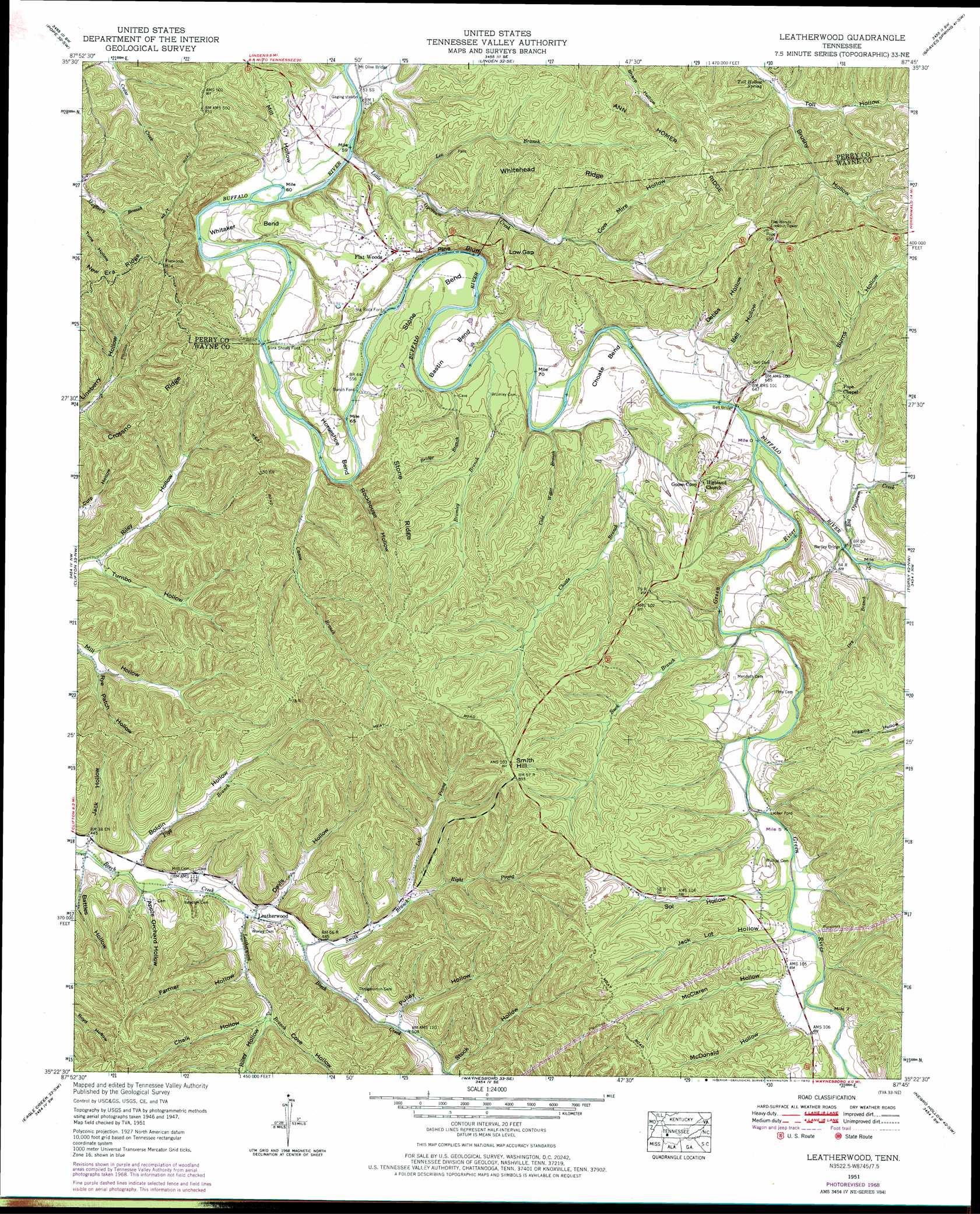
Leatherwood Topo Map Tennessee
To zoom in, hover over the map of Leatherwood
USGS Topo Quad 35087d7 - 1:24,000 scale
| Topo Map Name: | Leatherwood |
| USGS Topo Quad ID: | 35087d7 |
| Print Size: | ca. 21 1/4" wide x 27" high |
| Southeast Coordinates: | 35.375° N latitude / 87.75° W longitude |
| Map Center Coordinates: | 35.4375° N latitude / 87.8125° W longitude |
| U.S. State: | TN |
| Filename: | o35087d7.jpg |
| Download Map JPG Image: | Leatherwood topo map 1:24,000 scale |
| Map Type: | Topographic |
| Topo Series: | 7.5´ |
| Map Scale: | 1:24,000 |
| Source of Map Images: | United States Geological Survey (USGS) |
| Alternate Map Versions: |
Leatherwood TN 1936 Download PDF Buy paper map Leatherwood TN 1951, updated 1954 Download PDF Buy paper map Leatherwood TN 1951, updated 1970 Download PDF Buy paper map Leatherwood TN 1951, updated 1977 Download PDF Buy paper map Leatherwood TN 2010 Download PDF Buy paper map Leatherwood TN 2013 Download PDF Buy paper map Leatherwood TN 2016 Download PDF Buy paper map |
1:24,000 Topo Quads surrounding Leatherwood
Jeanette |
Pine View |
Chestnut Grove |
Pleasantville |
Beaverdam Springs |
Perryville |
Pope |
Linden |
Graves Spring |
Kimmins |
Bath Springs |
Clifton |
Leatherwood |
Topsy |
Riverside |
Olivehill |
Eagle Creek |
Waynesboro |
Negro Hollow |
Ovilla |
Wolf Pit Ridge |
Martins Mills |
Three Churches |
Collinwood |
Westpoint |
> Back to 35087a1 at 1:100,000 scale
> Back to 35086a1 at 1:250,000 scale
> Back to U.S. Topo Maps home
Leatherwood topo map: Gazetteer
Leatherwood: Bends
Bastin Bend elevation 180m 590′Choate Bend elevation 180m 590′
Horseshoe Bend elevation 178m 583′
Stone Bend elevation 182m 597′
Whitaker Bend elevation 179m 587′
Leatherwood: Bridges
Bartley Bridge elevation 173m 567′Bell Bridge elevation 173m 567′
Leatherwood: Cliffs
Pine Bluff elevation 192m 629′Leatherwood: Crossings
Bells Ford elevation 173m 567′Big Rock Ford elevation 162m 531′
Bromley Ford elevation 166m 544′
Bunch Ford elevation 161m 528′
Lacher Ford elevation 188m 616′
Opossum Creek Ford elevation 158m 518′
Slink Shoals Ford elevation 162m 531′
Leatherwood: Gaps
Low Gap elevation 211m 692′Leatherwood: Populated Places
Flat Woods elevation 206m 675′Leatherwood elevation 141m 462′
Lovie (historical) elevation 181m 593′
Leatherwood: Post Offices
Flatwoods Post Office elevation 206m 675′Leatherwood: Ridges
Ann Homer elevation 233m 764′Crossno Ridge elevation 230m 754′
Stone Ridge elevation 251m 823′
Whitehead Ridge elevation 253m 830′
Leatherwood: Springs
Toll Hollow Spring elevation 185m 606′Leatherwood: Streams
Big Opossum Creek elevation 177m 580′Bridge Branch elevation 167m 547′
Bromley Branch elevation 166m 544′
Buck Branch elevation 182m 597′
Canoe Branch elevation 161m 528′
Choate Branch elevation 168m 551′
Cold Water Branch elevation 175m 574′
Dry Branch elevation 179m 587′
Green River elevation 173m 567′
Leatherwood Branch elevation 137m 449′
Lee Branch elevation 167m 547′
Left Prong Smith Branch elevation 156m 511′
Little Opossum Creek elevation 158m 518′
Pigg Branch elevation 134m 439′
Pope Branch elevation 175m 574′
Right Prong Smith Branch elevation 156m 511′
Smith Branch elevation 142m 465′
Leatherwood: Summits
Smith Hill elevation 271m 889′Leatherwood: Valleys
Apple Orchard Hollow elevation 140m 459′Battles Hollow elevation 140m 459′
Bell Hollow elevation 189m 620′
Boldin Hollow elevation 138m 452′
Brushy Hollow elevation 193m 633′
Burns Hollow elevation 179m 587′
Chalk Hollow elevation 154m 505′
Cove Hollow elevation 154m 505′
Cow Mire Hollow elevation 199m 652′
Dabbs Hollow elevation 193m 633′
Davis Hollow elevation 145m 475′
Davis Hollow elevation 200m 656′
Farmer Hollow elevation 146m 479′
Jack Hollow elevation 136m 446′
Jack Lot Hollow elevation 194m 636′
McClaren Hollow elevation 201m 659′
McDonald Hollow elevation 199m 652′
Mill Hollow elevation 163m 534′
Pulley Hollow elevation 156m 511′
Riley Hollow elevation 154m 505′
Rochouse Hollow elevation 163m 534′
Rye Patch Hollow elevation 148m 485′
Sol Hollow elevation 192m 629′
Stock Hollow elevation 160m 524′
Turnbo Hollow elevation 140m 459′
Leatherwood digital topo map on disk
Buy this Leatherwood topo map showing relief, roads, GPS coordinates and other geographical features, as a high-resolution digital map file on DVD: