Columbia Topo Map Tennessee
To zoom in, hover over the map of Columbia
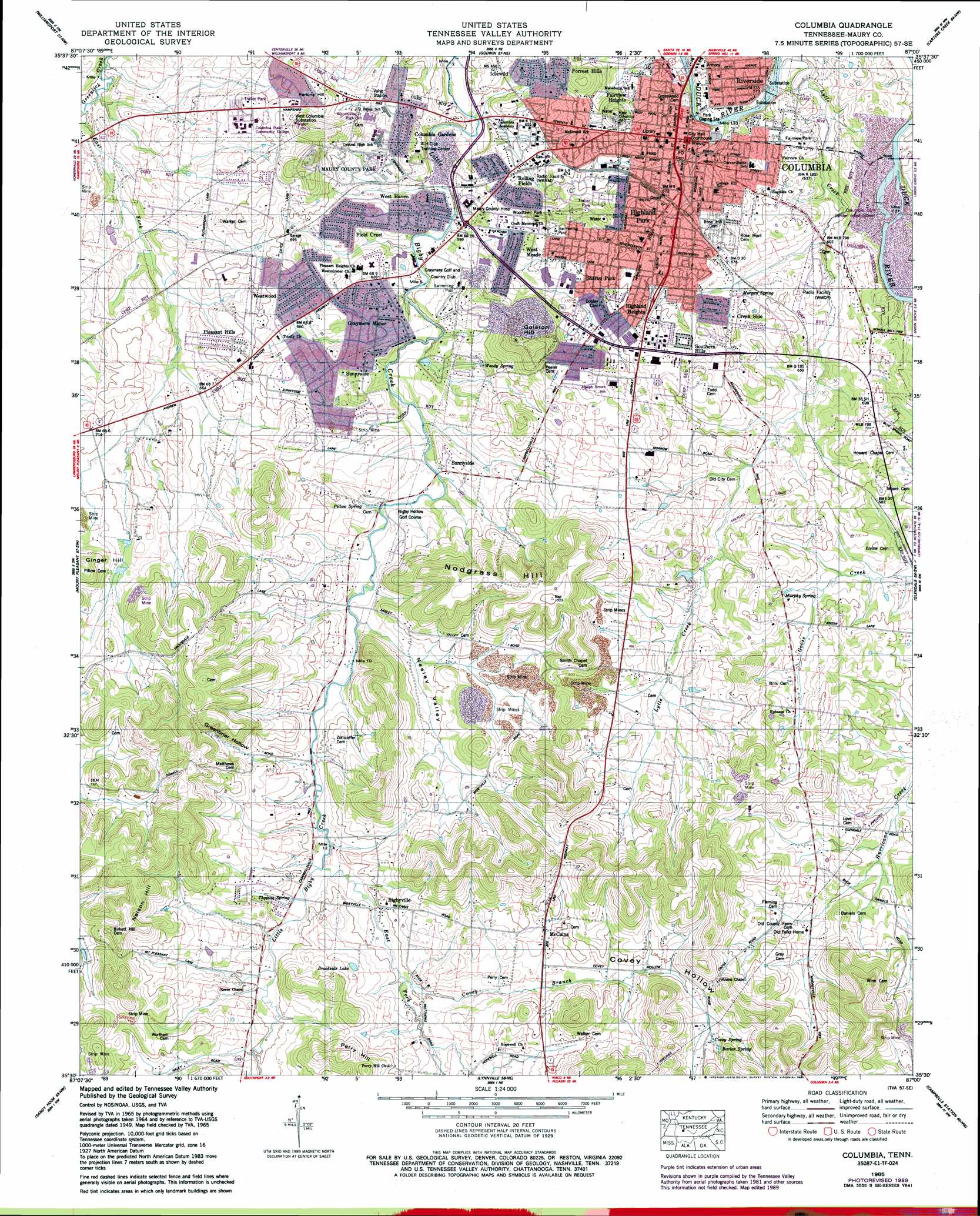
USGS Topo Quad 35087e1 - 1:24,000 scale
| Topo Map Name: | Columbia |
| USGS Topo Quad ID: | 35087e1 |
| Print Size: | ca. 21 1/4" wide x 27" high |
| Southeast Coordinates: | 35.5° N latitude / 87° W longitude |
| Map Center Coordinates: | 35.5625° N latitude / 87.0625° W longitude |
| U.S. State: | TN |
| Filename: | o35087e1.jpg |
| Download Map JPG Image: | Columbia topo map 1:24,000 scale |
| Map Type: | Topographic |
| Topo Series: | 7.5´ |
| Map Scale: | 1:24,000 |
| Source of Map Images: | United States Geological Survey (USGS) |
| Alternate Map Versions: |
Columbia TN 1936 Download PDF Buy paper map Columbia TN 1949 Download PDF Buy paper map Columbia TN 1965, updated 1967 Download PDF Buy paper map Columbia TN 1965, updated 1977 Download PDF Buy paper map Columbia TN 1965, updated 1990 Download PDF Buy paper map Columbia TN 1965, updated 1990 Download PDF Buy paper map Columbia TN 2010 Download PDF Buy paper map Columbia TN 2013 Download PDF Buy paper map Columbia TN 2016 Download PDF Buy paper map |
1:24,000 Topo Quads surrounding Columbia
Littlelot |
Primm Springs |
Theta |
Spring Hill |
Bethesda |
Greenfield Bend |
Williamsport |
Godwin |
Carters Creek |
Rally Hill |
Mount Joy |
Mount Pleasant |
Columbia |
Glendale |
Verona |
Summertown |
Sandy Hook |
Lynnville |
Campbells Station |
Lewisburg |
Ethridge |
Campbellsville |
Milky Way |
Brick Church |
Cornersville |
> Back to 35087e1 at 1:100,000 scale
> Back to 35086a1 at 1:250,000 scale
> Back to U.S. Topo Maps home
Columbia topo map: Gazetteer
Columbia: Dams
Riverside Dam elevation 166m 544′Columbia: Lakes
Brookside Lake elevation 229m 751′Columbia: Parks
Eva Gilbert Park elevation 232m 761′Fairview Park elevation 200m 656′
Maury County Park elevation 207m 679′
Pillow Park elevation 172m 564′
Pop Geers Park elevation 238m 780′
Woodland Park elevation 213m 698′
Woodlawn Park elevation 218m 715′
Columbia: Populated Places
Bigbyville elevation 215m 705′Columbia elevation 196m 643′
Columbia Gardens elevation 196m 643′
Creek Side elevation 207m 679′
Dooley (historical) elevation 217m 711′
Dukes Store (historical) elevation 217m 711′
Fairview Heights elevation 195m 639′
Field Crest elevation 200m 656′
Forrest Hills elevation 224m 734′
Graymere Manor elevation 199m 652′
Highland Heights elevation 218m 715′
Highland Park elevation 225m 738′
Hopewell elevation 227m 744′
Idlewild elevation 202m 662′
Lebanon Heights elevation 197m 646′
McCains elevation 235m 770′
Pleasant Hills elevation 212m 695′
Rankin elevation 211m 692′
Riverside elevation 191m 626′
Rolling Fields elevation 221m 725′
Sharon Park elevation 218m 715′
Southern Hills elevation 233m 764′
Sunnyside elevation 199m 652′
West Haven elevation 202m 662′
West Meade elevation 197m 646′
Westwood elevation 209m 685′
Columbia: Post Offices
Columbia Post Office elevation 193m 633′Columbia: Reservoirs
Morrow Lake elevation 204m 669′Stauffer Pond Number Twenty elevation 197m 646′
Columbia: Springs
Balar Spring elevation 266m 872′Covey Spring elevation 253m 830′
Morgan Spring elevation 198m 649′
Murphy Spring elevation 213m 698′
Pillow Spring elevation 194m 636′
Thomas Spring elevation 207m 679′
Woody Spring elevation 193m 633′
Columbia: Streams
Covey Branch elevation 210m 688′East Fork Greenlick Creek elevation 181m 593′
East Fork Little Bigby Creek elevation 201m 659′
Hopewell Branch elevation 214m 702′
Lytle Creek elevation 170m 557′
Columbia: Summits
Golston Hill elevation 288m 944′Nelson Hill elevation 297m 974′
Nodgrass Hill elevation 307m 1007′
Perkins Hill elevation 235m 770′
Perry Hill elevation 286m 938′
Rainey Hill elevation 247m 810′
Second Knob elevation 247m 810′
The Knob elevation 259m 849′
Columbia: Valleys
Covey Hollow elevation 233m 764′Greenbriar Hollow elevation 201m 659′
Neeley Valley elevation 196m 643′
Columbia digital topo map on disk
Buy this Columbia topo map showing relief, roads, GPS coordinates and other geographical features, as a high-resolution digital map file on DVD: