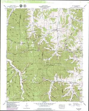
Mount Joy Topo Map Tennessee
To zoom in, hover over the map of Mount Joy
USGS Topo Quad 35087e3 - 1:24,000 scale
| Topo Map Name: | Mount Joy |
| USGS Topo Quad ID: | 35087e3 |
| Print Size: | ca. 21 1/4" wide x 27" high |
| Southeast Coordinates: | 35.5° N latitude / 87.25° W longitude |
| Map Center Coordinates: | 35.5625° N latitude / 87.3125° W longitude |
| U.S. State: | TN |
| Filename: | o35087e3.jpg |
| Download Map JPG Image: | Mount Joy topo map 1:24,000 scale |
| Map Type: | Topographic |
| Topo Series: | 7.5´ |
| Map Scale: | 1:24,000 |
| Source of Map Images: | United States Geological Survey (USGS) |
| Alternate Map Versions: |
Mt Joy TN 1936 Download PDF Buy paper map Mt. Joy TN 1951, updated 1957 Download PDF Buy paper map Mt. Joy TN 1951, updated 1979 Download PDF Buy paper map Mount Joy TN 2010 Download PDF Buy paper map Mount Joy TN 2013 Download PDF Buy paper map Mount Joy TN 2016 Download PDF Buy paper map |
1:24,000 Topo Quads surrounding Mount Joy
> Back to 35087e1 at 1:100,000 scale
> Back to 35086a1 at 1:250,000 scale
> Back to U.S. Topo Maps home
Mount Joy topo map: Gazetteer
Mount Joy: Cliffs
Pickard Bluff elevation 219m 718′Rock Hole Bluff elevation 236m 774′
Mount Joy: Falls
Eagle Falls elevation 239m 784′Mount Joy: Gaps
Cox Low Gap elevation 265m 869′Pig Pen elevation 279m 915′
Mount Joy: Populated Places
Aethra elevation 294m 964′Bachelder elevation 291m 954′
Hampshire elevation 184m 603′
Lucerne (historical) elevation 213m 698′
Mount Joy elevation 208m 682′
Seth elevation 272m 892′
Mount Joy: Post Offices
Hampshire Post Office elevation 185m 606′Mount Joy: Reservoirs
Fox Lake elevation 241m 790′Hamilton Lakes elevation 241m 790′
Mount Joy: Ridges
Aunt Lude Ridge elevation 281m 921′East Prong Ridge elevation 286m 938′
Five Acre Ridge elevation 289m 948′
Hampshire Ridge elevation 284m 931′
Hickman Ridge elevation 276m 905′
Negro Ridge elevation 266m 872′
Pisgah Ridge elevation 261m 856′
Salt Lick Ridge elevation 287m 941′
Whiteside Ridge elevation 258m 846′
Mount Joy: Springs
Dickson Spring elevation 201m 659′Gum Spring elevation 258m 846′
Mount Joy: Streams
Baptist Branch elevation 182m 597′Barr Hollow Branch elevation 203m 666′
Bates Creek elevation 204m 669′
Beckum Hollow Branch elevation 204m 669′
Bell Branch elevation 212m 695′
Bell Branch elevation 177m 580′
Cox Branch elevation 227m 744′
Dog Branch elevation 199m 652′
East Fork Curry Branch elevation 182m 597′
East Prong Catheys Creek elevation 207m 679′
Estes Branch elevation 211m 692′
Flat Branch elevation 203m 666′
Goat Hollow Branch elevation 210m 688′
Henry Branch elevation 214m 702′
Hill Branch elevation 210m 688′
Hunt Branch elevation 211m 692′
Jacks Branch elevation 215m 705′
Kelly Branch elevation 219m 718′
McClain Branch elevation 214m 702′
McClanahan Branch elevation 182m 597′
Pogue Branch elevation 217m 711′
Pogue Hollow Branch elevation 213m 698′
Raines Hollow Branch elevation 201m 659′
Star Branch elevation 224m 734′
Trotters Branch elevation 209m 685′
Webster Branch elevation 201m 659′
Whiteside Branch elevation 200m 656′
Worley Hollow Branch elevation 193m 633′
Wright Branch elevation 220m 721′
Mount Joy: Summits
Bingham Hill elevation 236m 774′Church House Hill elevation 283m 928′
Cothran Hill elevation 271m 889′
Hughes Hill elevation 281m 921′
McClanahan Hill elevation 283m 928′
Mount Joy: Valleys
Akin Hollow elevation 199m 652′Aleck Pogue Hollow elevation 187m 613′
Barker Hollow elevation 210m 688′
Barr Hollow elevation 200m 656′
Beckum Hollow elevation 210m 688′
Betts Hollow elevation 205m 672′
Caney Hollow elevation 224m 734′
Cooper Hollow elevation 226m 741′
Cox Hollow elevation 207m 679′
George Pogue Hollow elevation 214m 702′
Holloway Hollow elevation 211m 692′
King Hollow elevation 208m 682′
Kittrell Hollow elevation 212m 695′
Knowles Hollow elevation 206m 675′
Kyle Hollow elevation 217m 711′
Ledbetter Hollow elevation 230m 754′
Mill Hollow elevation 226m 741′
Mill Hollow elevation 238m 780′
Mitchell Hollow elevation 206m 675′
Poor Farm Hollow elevation 180m 590′
Rails Hollow elevation 224m 734′
Rails Hollow elevation 203m 666′
Raines Hollow elevation 203m 666′
Reed Hollow elevation 182m 597′
Sandy Mitchell Hollow elevation 240m 787′
Scribner Hollow elevation 199m 652′
Seton Hollow elevation 214m 702′
Sweet Gum Hollow elevation 225m 738′
Thompson Hollow elevation 194m 636′
Tom Wright Hollow elevation 224m 734′
Watson Hollow elevation 213m 698′
Webster Hollow elevation 206m 675′
Wheeler Hollow elevation 225m 738′
Whiteside Hollow elevation 204m 669′
Woodside Hollow elevation 203m 666′
Worley Hollow elevation 204m 669′
Mount Joy digital topo map on disk
Buy this Mount Joy topo map showing relief, roads, GPS coordinates and other geographical features, as a high-resolution digital map file on DVD:


